
考古学的伟大谜团:从天空中揭示的古代亚马逊世界
Great mysteries of archaeology: an ancient Amazonian wo…
Archaeologists thought ancient Amazonia was only home to wandering people, but new technology has uncovered complex societies living in forest cities.
考古学家曾认为古代亚马逊地区只居住着游牧民族,但新技术已经发现了森林城市中复杂的社会。
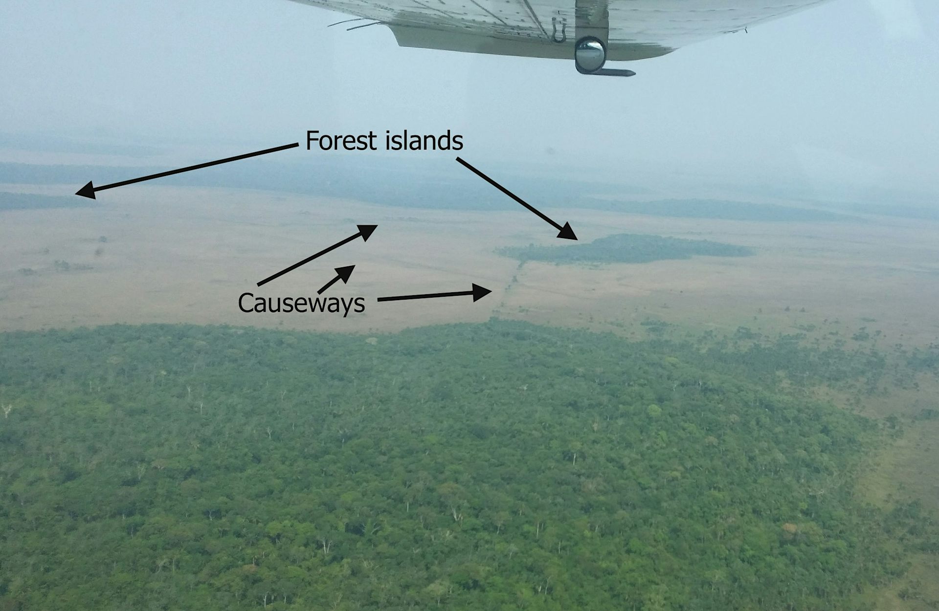
From the air, you see it only through the constant jolt, tilt and shudder of the low-flying Cessna aircraft. The landscape of the Llanos de Moxos, northern Bolivia, appears as a disconnected patchwork of open grassland savannahs, forest islands and lakes.
从空中看,你只能通过低飞的塞斯纳飞机持续不断的颠簸、倾斜和摇晃来发现它。玻利维亚北部莫克索斯平原(Llanos de Moxos)的景观呈现出不连贯的拼贴画:开阔的草原稀树草原、森林岛屿和湖泊交错分布。
It feels random, almost unreadable. Only gradually does the pattern resolve itself: raised causeways or paths fanning out to link the forest islands, and a dense, scattered web of canals threading the terrain. Slowly you realise it’s a structured network of intersecting lines, enclosures and roads – the imprint of past human design.
感觉是随机的,几乎无法解读。只有逐渐地,其模式才会显现出来:抬高的堤道或小径像扇子一样延伸,连接着这些森林岛屿;以及一张密集的、零散的运河网络穿梭于地形之中。你慢慢意识到,这是一张由交错线条、围场和道路构成的结构化网络——这是过去人类设计的印记。
If you stand on the open savannah, there is almost nothing to see of this ancient network. The horizon feels open, with fires in the distance from local people burning pastures and clearing forest as dry season begins. The old geometry is still faintly perceptible, but you have to know how to look.
如果你站在开阔的稀树草原上,几乎看不到这古老网络的任何痕迹。地平线显得开阔,远处有当地人燃烧牧场和清理森林留下的火光,随着旱季的开始。古老的几何结构仍然隐约可辨,但你必须知道如何去看。
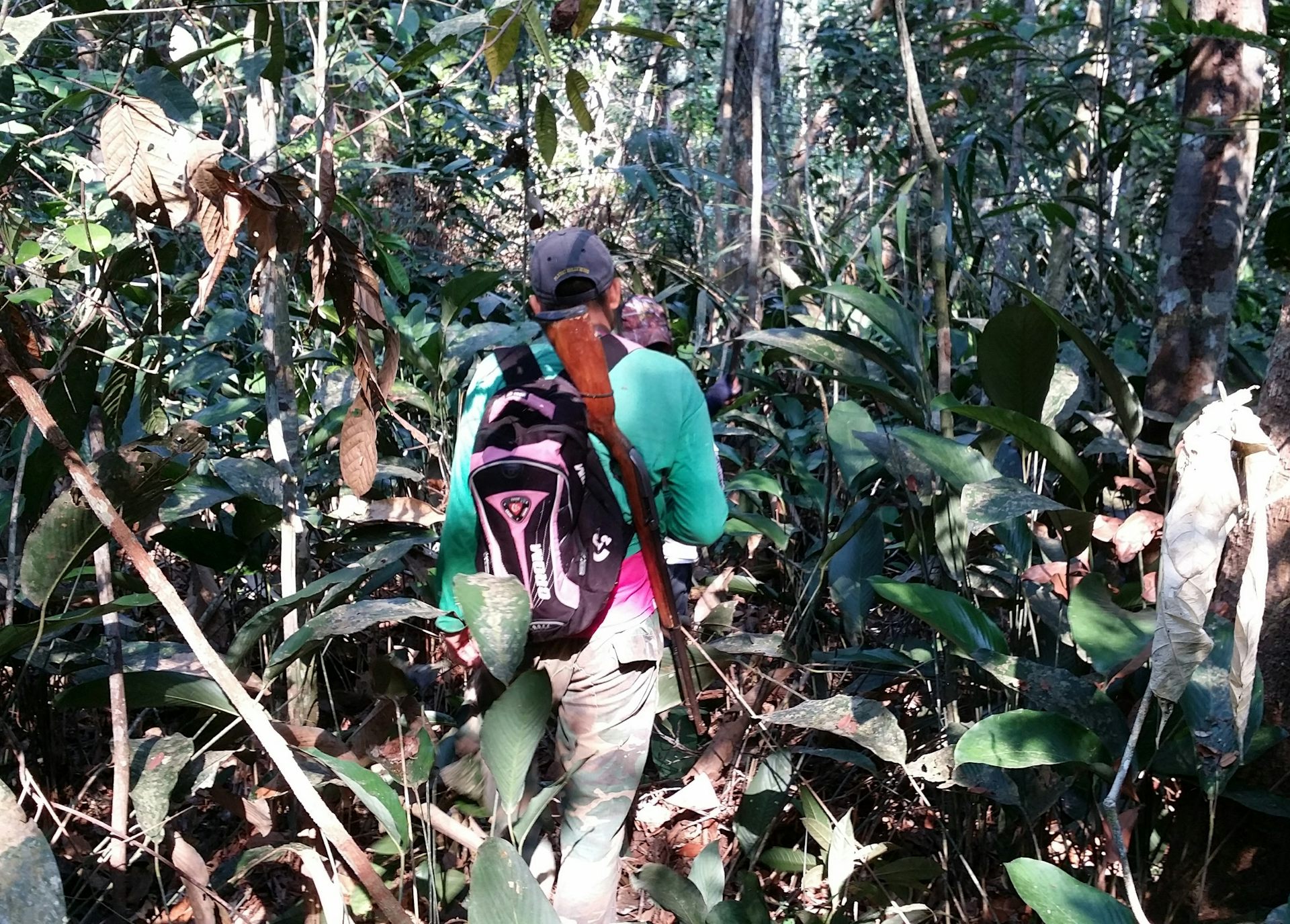
Step into the patches of forest and the canopy closes in. The earth softens underfoot and mosquitoes descend in relentless swarms. The sweat on your neck thickens into a humid film, carrying the familiar scent of suncream and the sharper, chemical note of DEET.
走进一片片森林,树冠便密闭下来。脚下的大地变得柔软,蚊子成群结队地降临。脖子上的汗水凝结成一层潮湿的薄膜,带着防晒霜熟悉的香味和DEET更尖锐、化学的气味。
In the uneven light between the trees, the landscape dissolves into subtle rises and depressions. Against the rhythmic swish of machetes as our guides cut through the vegetation, your mind tries to piece together the fragments of structures into something coherent. Flying overhead doesn’t reveal anything about this forest area in the way that it does with the savannah. But fortunately recent advances in technology have transformed what we are able to see.
在树木间不均匀的光线下,景观溶解为微妙的高低起伏。伴随着向导们砍伐植被时,马切塔有节奏的挥动声,你的思绪试图将这些结构碎片拼凑成一个连贯的整体。从上方飞过无法像在稀树草原上那样揭示这片森林区域的任何信息。但幸运的是,技术上的最新进步改变了我们所能看到的范围。
Archaeological explorations in this part of the world have been completely changed by lidar in the past couple of decades. Lidar maps an area from a plane or drone by bouncing rapid laser pulses off the Earth’s surface. Some of these pulses penetrate the forest canopy, reach the ground and reflect back to the sensor.
在过去几十年里,该地区考古探索已经彻底改变了,得益于激光雷达(lidar)技术。激光雷达通过从飞机或无人机向地球表面反射快速的激光脉冲来绘制区域地图。其中一些脉冲能够穿透森林冠层,到达地面并反射回传感器。
By measuring the return time, the system can generate highly precise three-dimensional models of the terrain. This allows you to strip away the camouflage of vegetation, making it possible to see what lies below the Amazonian forest for the first time.
通过测量返回时间,系统可以生成高度精确的三维地形模型。这使得我们能够剥去植被的伪装,首次看到亚马逊雨林之下隐藏的内容。
It reveals the ancient Llanos de Moxos as not simply a collection of settlements, but an entire urbanised landscape. A large part in the south-east of this region belonged to the Casarabe culture, which dominated between around AD500 and 1400. It extends across 20,000km², which is roughly the size of New Jersey in the US.
它揭示了古老的莫克索斯平原不仅仅是一组定居点,而是一个完整的城市化景观。该地区东南方很大一部分属于卡萨拉贝文化(Casarabe culture),其鼎盛时期大约在公元500年至1400年之间。它横跨20,000平方公里,大致相当于美国新泽西州的面积。
The Casarabe organised into a hierarchy of four different sizes of settlements (those forest islands mentioned above) . The biggest ones – the primary settlements – were as large as 3km² or 300 hectares. That’s enough space for over 400 football pitches, suggesting that they could have accommodated substantial numbers of people.
卡萨拉贝人组织成了一个包含四种不同规模的定居点等级制度(即上述提到的森林岛屿)。最大的——主要定居点——有高达3平方公里或300公顷的面积。这足够容纳超过400个足球场,表明它们能够安置大量人口。
Welcome to our series on the great mysteries of archaeology. Viking explorers, Amazonian cities, artefacts from before civilisation. Archaeology may be all about the past, but it’s constantly shifting with every scientific discovery. This series will dig into some of the most fascinating debates in the field today.
欢迎来到我们关于考古学伟大奥秘系列节目。维京探险家、亚马逊城市、文明前的文物。考古学可能关乎过去的一切,但它随着每一次科学发现都在不断变化。本系列将深入探讨该领域目前一些最引人入胜的争论话题。
These settlements connect along the raised causeways to smaller secondary and tertiary sites a number of kilometres away, all of which were permanently inhabited as opposed to empty ceremonial hubs. A fourth tier consists of groups of isolated mounds located out in the pampas, which likely correspond to dwelling areas occupied by farmers who would have worked the fields.
这些定居点沿着抬高的堤道连接到数公里外更小的次级和三级遗址,所有这些地方都是永久居住区,而非空置的仪式中心。第四个层级则由散布在潘帕斯草原上的孤立土丘群组成,这些土丘可能对应着农民居住的区域,他们会在那里耕作田地。
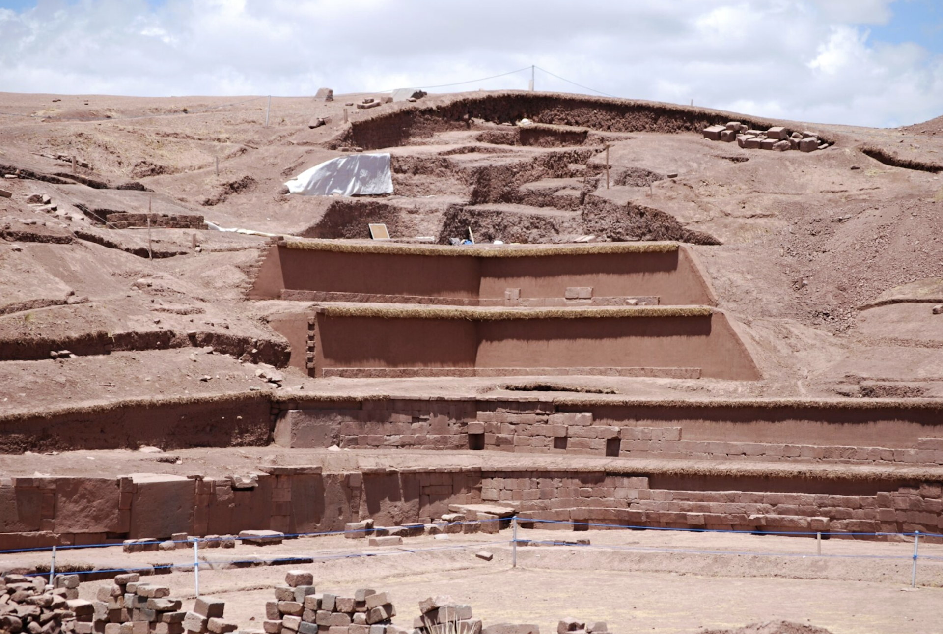
It’s not possible to show a lidar image of these four different types of sites interconnecting because they are too far apart for the resolution available, but the image below of a primary settlement known as Loma Cotoca shows the kinds of things we are now documenting.
由于这四种不同类型的遗址之间距离太远,目前的分辨率无法展示它们相互连接的激光雷达图像,但下面这张名为洛马科托卡(Loma Cotoca)的主要定居点的激光雷达照片,展示了我们目前正在记录的类型的东西。
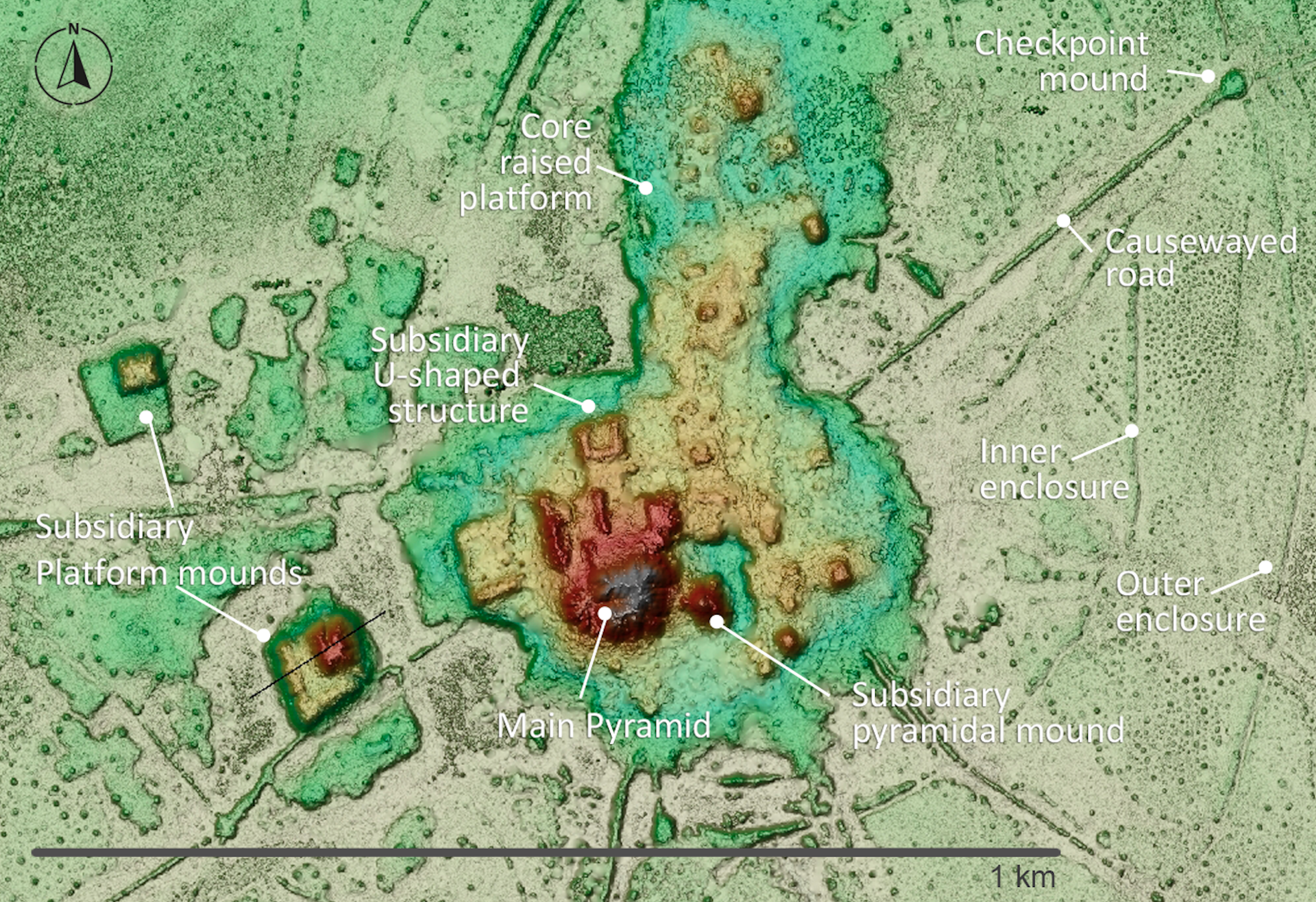
It features some very impressive civic-ceremonial architecture: conical pyramids over 20 metres tall and U-shaped structures that may have acted as areas for public gatherings for speeches or ceremonies. These were built on top of man-made platforms rising as much as five metres off the ground and extending over 20 hectares. To be clear, this is all still hiding under the forest, but the lidar data reveals the shape, height and layout of what lies below.
建造这些建筑所移动的泥土体积,可与安第斯山脉另一侧西南方向几百英里处的阿卡帕纳(Akapana)等著名的安第斯纪念碑相媲美——在某些情况下甚至超过了它们。
The volume of earth moved to create this architecture would have rivalled – and in some cases exceeded – that of well known Andean monuments such as Akapana a few hundred miles to the south-west on the other side of the Andes. Akapana was the epicentre of the Tiwanaku empire that dominated the southern Andes between about AD600 and 1000.
阿卡帕纳是蒂瓦纳库帝国(Tiwanaku empire)的中心地带,该帝国在公元600年至1000年间主导着南安第斯地区。
Yet where monuments like Akapana were surrounded by classic, compact bounded cities with thousands of inhabitants, the Casarabe equivalent was completely different. This was dispersed, low-density living amid extensive green space – a form of tropical urbanism that challenges longstanding assumptions about this area as sparsely populated and only lightly modified. It invites comparison with other low-density tropical urban landscapes such as the Maya in central America and the Angkor in latter day Cambodia.
然而,像阿卡帕纳这样的纪念碑周围是拥有数千名居民的经典、紧凑的边界城市,而卡萨拉贝(Casarabe)的对应模式则完全不同。这是一种分散的、低密度的生活方式,置于广阔的绿地之中——这是一种挑战了长期以来关于该地区人口稀少和改造程度轻微假设的热带城市主义形式。它让人联想到中美洲的玛雅文明以及后期的柬埔寨吴哥文化等其他低密度热带城市景观。
Equally important is the coherence of the Casarabe system. The settlements are rarely isolated, part of a tightly connected network with shared water-management systems. It was clearly all planned and coordinated, designed not only as living spaces but for integrating the population across the region.
同样重要的是卡萨拉贝系统的连贯性。这些定居点很少是孤立的,它们是一个与共享水利系统紧密连接的网络的一部分。这显然都是经过规划和协调的,其设计目的不仅是作为居住空间,更是为了整合整个地区的居民人口。
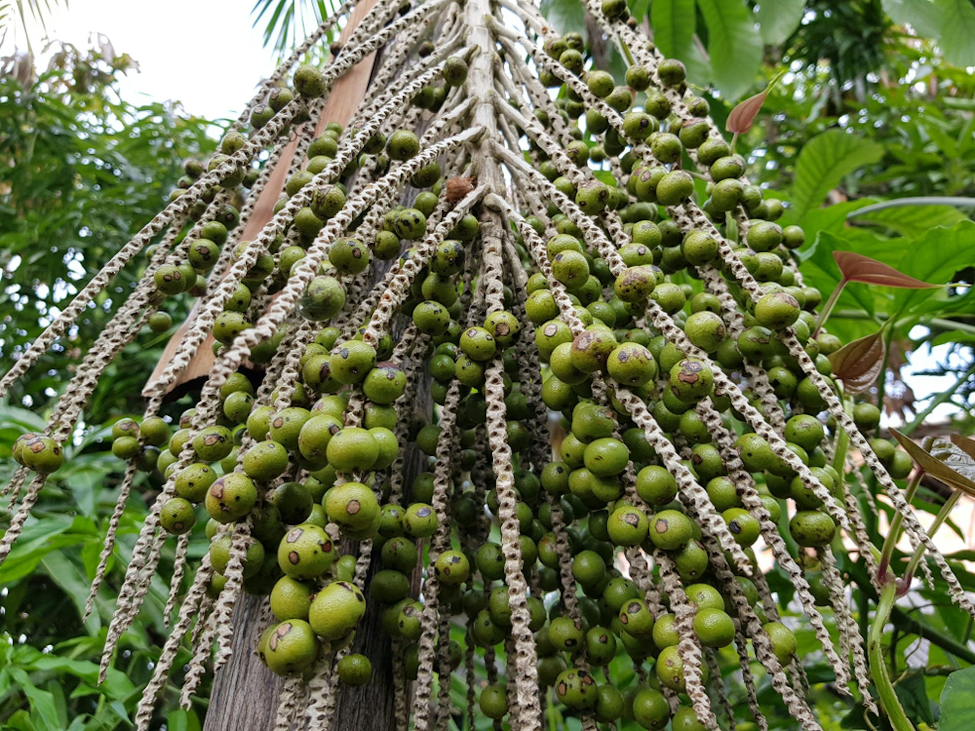
We can see that the Casarabe were sustained by drained-field agriculture: the canals were dug to make the land viable for planting during the wet season. The most prominent crop was maize, but there was a remarkable diversity of other produce. This was all embedded within a landscape that was engineered through reservoirs and farm ponds, which helped the Casarabe sustain cultivation and maintain access to water through the dry season in this extremely seasonal environment.
我们可以看到,卡萨拉贝人依靠排水农田农业生存:运河被挖掘出来,使土地在雨季种植成为可能。最主要的作物是玉米,但其他作物的多样性也十分显著。所有这些都嵌入在一个通过水库和农田池塘进行工程改造的景观中,这帮助卡萨拉贝人在这个极具季节性的环境中维持了耕种并保证了旱季的水源供应。
Also very noticeable is the fact that all the major architectural features and burial sites are oriented north-north-west. This suggests these people may have been led by cosmology, with important celestial bodies or regions of the night sky serving as symbolic reference points – hinting at a world where infrastructure, settlement and belief were inseparable.
另一个非常引人注目的是,所有的主要建筑特征和墓地都朝向北西北。这表明这些人的生活可能受到宇宙论的指引,重要的天体或夜空区域充当着象征性的参照点——暗示了一个基础设施、定居点和信仰密不可分的世界。
Rethinking the Amazon
重新审视亚马逊
The Casarabe culture covered much less than 1% of Amazonia, which is the whole tropical interior of South America, spanning close to half of the entire continent. For much of the 20th century, this vast area was viewed by archaeologists as an environment that was limiting for human existence.
卡萨拉贝文化所覆盖的区域不到整个亚马逊地区(即南美洲的整个热带内陆)的1%,而该地区横跨了几乎半个大陆。在20世纪的大部分时间里,考古学家们认为这片广阔的区域对人类生存而言是一个限制性的环境。
Poor soils, scarce game, extreme El Niño floods and droughts, and the challenges of tropical disease were all thought to constrain human populations to small, wandering groups living off the land as best they could. Large, settled societies – let alone towns or cities – were considered unlikely, if not impossible.
贫瘠的土壤、稀缺的猎物、极端的厄尔尼诺洪水和干旱,以及热带疾病带来的挑战,都被认为是将人类人口局限在小型、游荡的群体中,这些群体只能依靠当地资源勉强维持生计。大型定居社会——更不用说城镇或城市——被认为是不可能实现的,甚至是不可能的。
This view began to shift in the late 20th century for several reasons. Archaeologists realised that Amazonian people had been domesticating a diversity of plants since the end of the Ice Age. They manufactured some of the earliest ceramics in the Americas, and also devised soils known as Amazonian Dark Earths, which combined charcoal, bone and waste materials with the existing poor-quality soil to make it fertile enough for widespread farming.
由于几个原因,这种观点开始在20世纪后期发生转变。考古学家们意识到,亚马逊地区的居民自冰河时代末期以来就一直在驯化各种各样的植物。他们制造了美洲最早的陶瓷之一,还开发出被称为“亚马逊黑土”的土壤,该土壤将木炭、骨骼和废弃物与现有的贫瘠土壤混合,使其肥沃到足以进行广泛的耕种。
It also became apparent that just like the Casarabe people, many other cultures across Amazonia had reclaimed vast expanses of seasonally flooded savannahs over several thousand years to create raised and drained field systems.
此外,人们还发现,许多其他跨越亚马逊地区的文化,就像卡萨拉贝人一样,在数千年间重新开发了广阔的季节性泛滥稀树草原,从而创造出抬高和排水的耕地系统。
These discoveries were evidence of long-term settlement and landscape management far beyond what was previously thought possible. It meant Amazonia was not simply a backdrop to human activity; much of the landscape was shaped over the last 13 millennia by the people who lived there.
这些发现证明了长期定居和景观管理的能力,其程度远超此前人的想象。这意味着亚马逊地区不仅仅是人类活动的背景;大部分景观是在过去一万三千年中被居住在这里的人们塑造出来的。
Enter lidar
进入激光雷达
Like lasers in the sky, lidar technology has accelerated this transformation in our understanding. The digital process feels near-magical, a “vegetation removal algorithm” that reveals the secrets below.
就像天空中的激光一样,激光雷达技术加速了我们理解上的这场变革。这个数字化过程近乎神奇,它是一个“植被移除算法”,揭示了地下的秘密。
In practice, however, working with lidar in Amazonia is anything but straightforward. Running such a project here, as I have done, can feel like one of the greatest emotional rollercoasters in field archaeology. It’s all anticipation, frustration and sudden revelation – only comparable, perhaps, with shipwreck exploration.
然而,在实践中,使用激光雷达勘探亚马逊地区绝非易事。像我所做的那样开展这样的项目,感觉就像是野外考古学中最巨大的情感过山车。这充满了期待、挫折和突然的顿悟——或许只能与船只残骸探索相媲美。
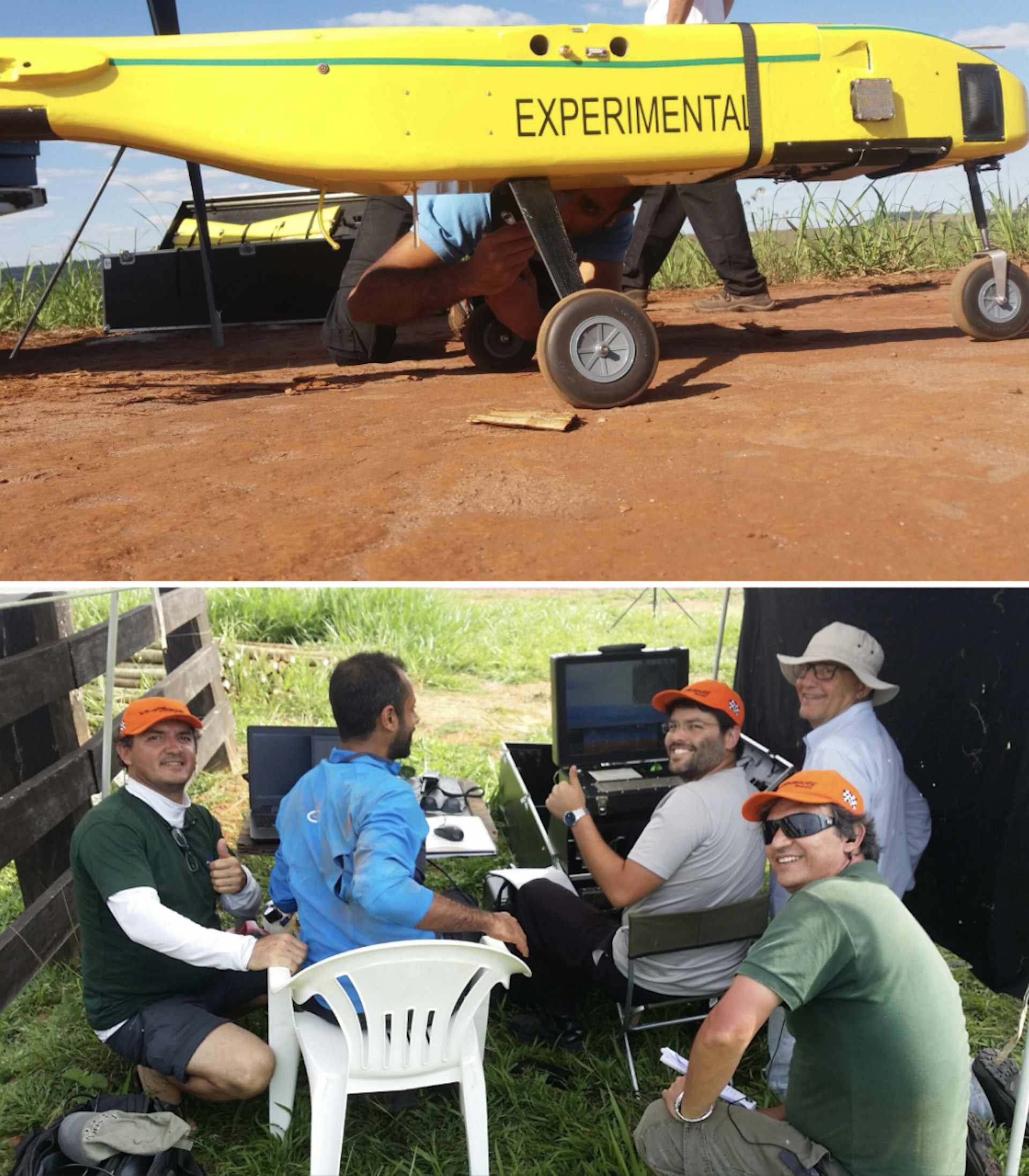
Depending on what technology is available and most suitable for exploring a particular area, I’ve worked with lidar attached to drones, aeroplanes and helicopters. I’ve learned through trial and error that the technology is only as effective as the logistics and personalities behind it – above all on one occasion when we were trying to integrate a Hungarian lidar sensor with a Brazilian drone.
根据可用的技术以及最适合勘探特定区域的技术,我曾使用安装在无人机、飞机和直升机上的激光雷达。我通过反复试验了解到,这项技术的有效性仅取决于其背后的后勤保障和人员素质——尤其是在有一次我们试图将匈牙利的激光雷达传感器与巴西的无人机集成时。
Lidar can perform beautifully one day and fail the next, depending on the equipment, weather, terrain, batteries, communications and the sheer difficulty of operating in remote Amazonian conditions.
激光雷达的能力可能一天表现完美,而第二天就可能会失败,这取决于设备、天气、地形、电池、通信以及在偏远亚马逊地区操作的难度本身。
Flights must be carefully planned in remote areas with limited infrastructure, where convective clouds, smoke from fires, wind and even vultures riding thermals can disrupt data acquisition. You have to arrange fuel in advance and improvise landings wherever a safe clearing can be found. Here’s our team refuelling a lidar helicopter in the football field of a small village in Acre state, western Brazil:
在基础设施有限的偏远地区进行飞行时必须精心规划,因为对流云、火灾烟雾、风甚至乘热气流飞行的兀鹫都可能干扰数据采集。你必须提前安排燃料,并在任何能找到安全空地的位置即兴降落。这是我们的团队在巴西西部阿克州的一个小村庄的足球场为激光雷达直升机加油:
You also have to do constant troubleshooting with the technology, such as making sure it’s calibrated correctly and that the data from different flight paths all aligns. What appears in the final images as a seamless “removal” of the forest is, in reality, the product of improvisation, negotiation and persistence.
你还必须对技术进行持续的故障排除,例如确保其校准正确,并确保来自不同飞行路径的数据都能对齐。最终图像中看似无缝的“森林移除”,实际上是即兴发挥、谈判和坚持的结果。
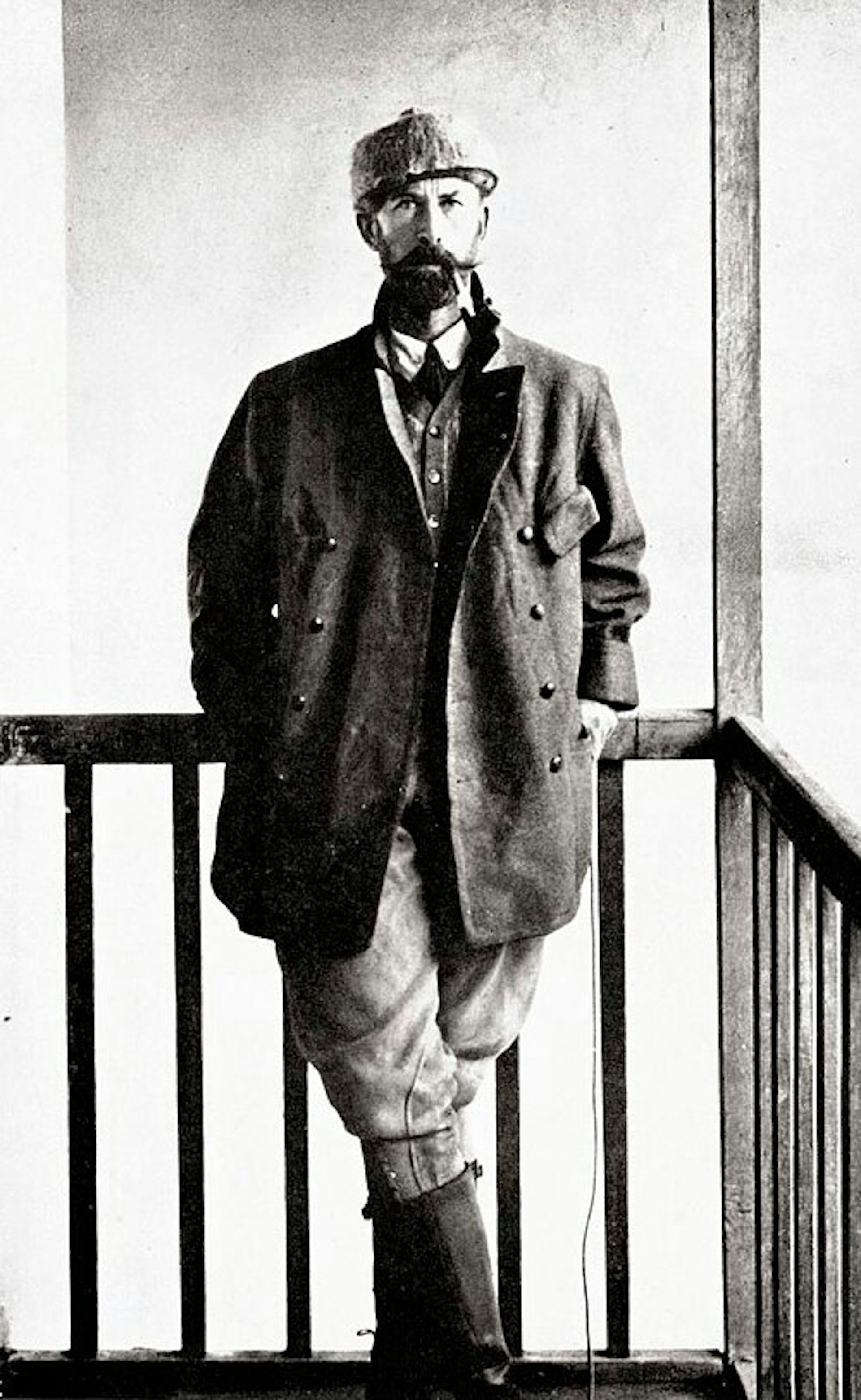
But given all these challenges, it makes the first successful images all the more powerful when they finally appear. The reward is that we’re finally finding the “lost civilisation” that explorers like Percy Fawcett were searching for a century ago, but by cajoling a drone rather than battering through jungle.
但考虑到所有这些挑战,当第一张成功的图像出现时,它们显得更加震撼人心。回报是,我们终于找到了像珀西·福塞特这样的探险家一个世纪前一直在寻找的“失落文明”,只不过这次不是通过硬闯丛林,而是通过安抚无人机。
Incidentally, this technology also has important uses beyond archaeology. It can help people to locate and harvest crops like rubber or açaí palm fruits without having to clear so much rainforest. It is also used by pioneering projects such as Amazonia Revelada, which helps Indigenous and traditional people of the Amazon to prove their historic presence within an area to ward off modern commercial interests like loggers or farmers, while also protecting the living history and nature embedded in these landscapes.
顺便说一句,这项技术在考古学领域之外也有重要的用途。它可以帮助人们定位和采摘橡胶或阿萨伊棕榈果等作物,而无需清理大量的热带雨林。它还被像“亚马逊揭秘”(Amazonia Revelada)这样的先驱项目使用,该项目帮助亚马逊的原住民和传统人民证明他们在某一地区的历史存在,以抵御伐木工或农民等现代商业利益,同时保护这些景观中蕴含的活态历史和自然环境。
Other lidar discoveries
其他激光雷达发现
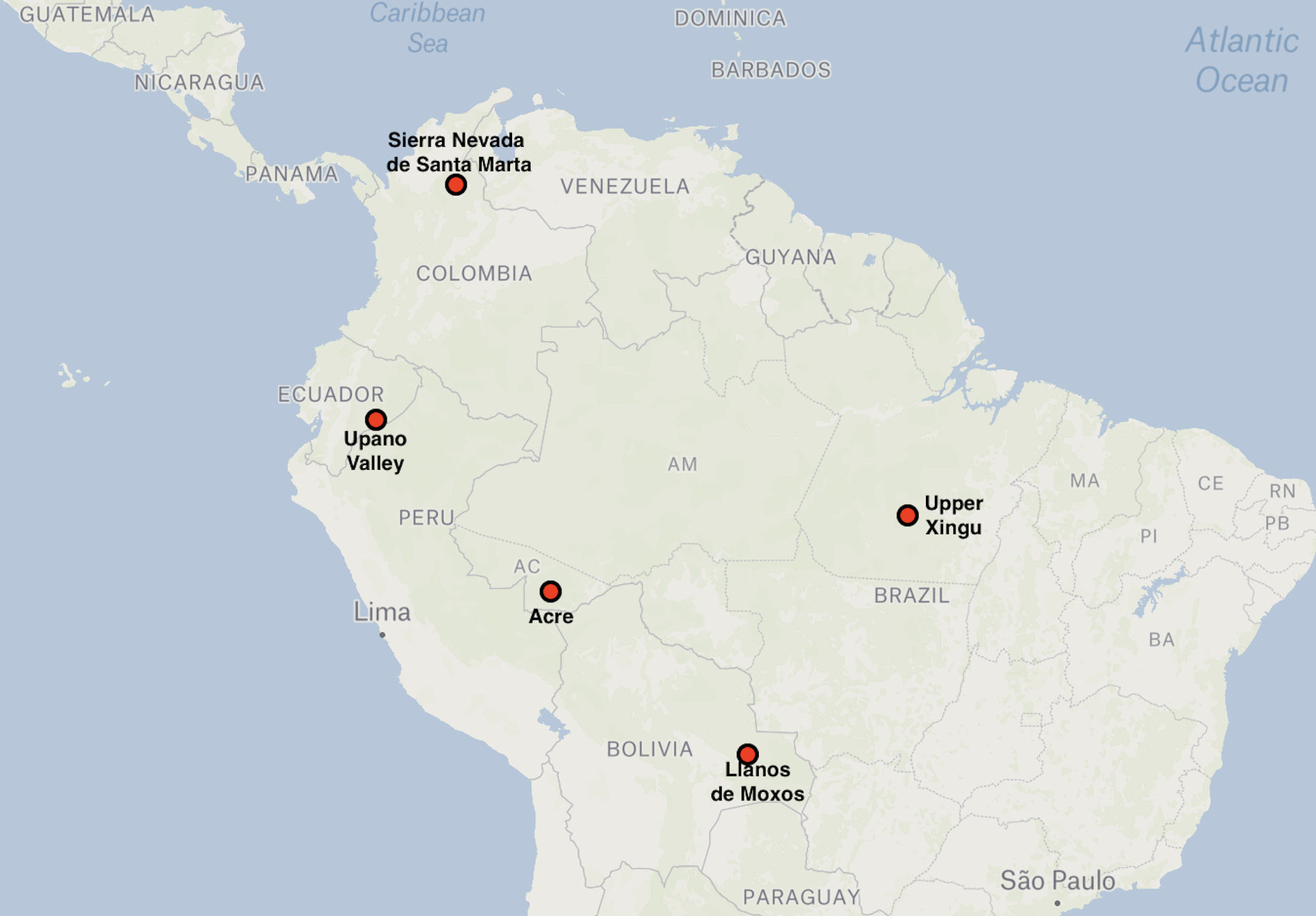
Lidar surveys by French and Ecuadorian archaeologists have revealed that the Llanos de Moxos was certainly not the only example of large-scale, highly integrated society in Amazonia. The Upano Valley, which covers some 300-600km² on the mountainous forest of the Ecuadorian eastern flanks of the Andes, offers another striking example – this time from between about 500BC and AD600–700.
法国和厄瓜多尔的考古学家通过激光雷达调查发现,莫克索斯平原绝非亚马逊地区大规模、高度整合社会的唯一例证。上帕诺谷地位于安第斯山脉厄瓜多尔东部山区森林,占地约300-600平方公里,提供了另一个引人注目的例子——这次的年代跨度约为公元前500年至公元后600-700年之间。
Lidar discovery areas
激光雷达发现区域
In Upano, archaeologists have been able to map a vast network of settlements connected by extensive road systems, with large platforms and clusters of buildings arranged in organised layouts across a broad area.
在乌帕诺(Upano),考古学家已经能够绘制出一个由广泛道路系统连接的广阔定居点网络,该区域内大型平台和建筑群按照有组织的布局排列。
What stands out is not just the scale – thousands of structures – but the rigour of the planning. The settlements didn’t just grow randomly, but as part of a deliberate design: we see straight lines of flat-topped platforms laid out in repeating rows and connected by straight paths that cut cleanly across the landscape, as you can see below.
最引人注目之处,不仅仅是规模——数以千计的结构——更是规划的严谨性。这些定居点并非随机增长,而是作为一项有意识的设计的一部分:我们看到的是一排排平顶平台构成的直线,它们排列成重复的行,并通过笔直的小路连接,这些小路干净利落地横切着整个景观,如您在下方所见。
Again, this is not urbanism in the conventional sense of dense, continuous occupation. There would have been none of the vertical stacking of buildings that you’d get in European settlements, and there were also green spaces between platform complexes – much more like a forest city.
再次强调,这并非传统意义上密集、连续的城市化。它不会有欧洲定居点那种垂直堆叠的建筑结构,平台群之间也有绿地——更像一座森林城市。
Like the Casarabe region, this is a distributed settlement pattern that is both open and highly structured, but the arrangement is much more compact. This reflects the limited flat space available on the upper terraces of the Upano River, which rise up to 100 metres above the surrounding landscape.
与卡萨拉贝地区类似,这是一种分散的聚落模式,它既开放又高度结构化,但其布局更加紧凑。这反映了乌帕诺河上层台地上有限的平坦空间,该河流域比周围地貌高出多达100米。
Elsewhere in Amazonia, we see more variations. In the Upper Xingu of central Brazil, interconnected settlements were arranged around a shared ceremonial and road network, again suggesting a regionally coordinated social world.
在亚马逊的其他地方,我们看到了更多的变异。在巴西中部上辛古地区,相互连接的定居点围绕着一个共同的仪式和道路网络排列,这再次表明了一个区域协调的社会世界。
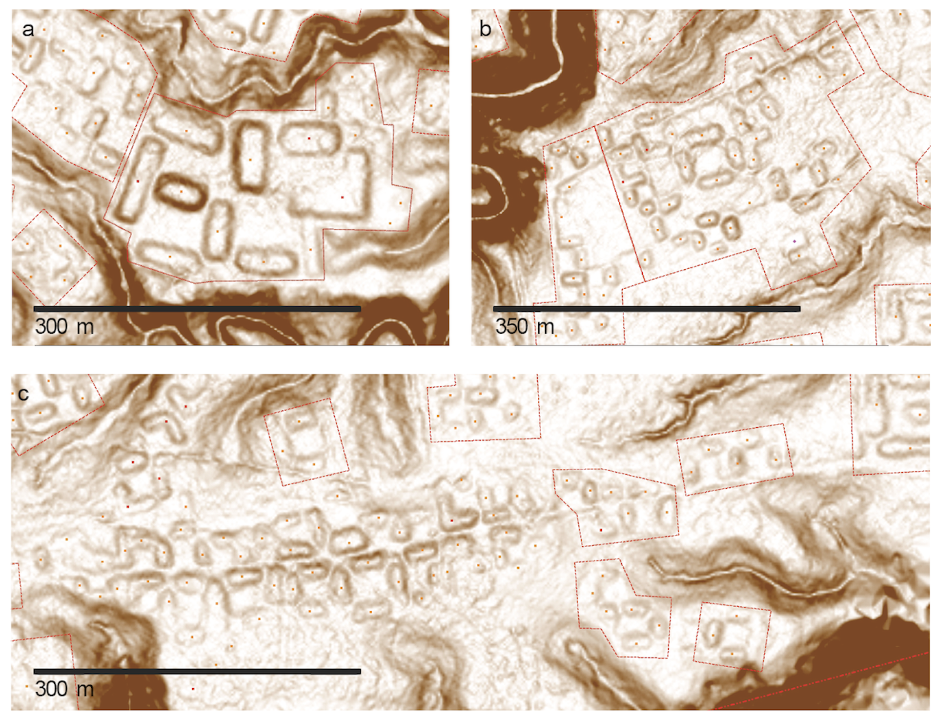
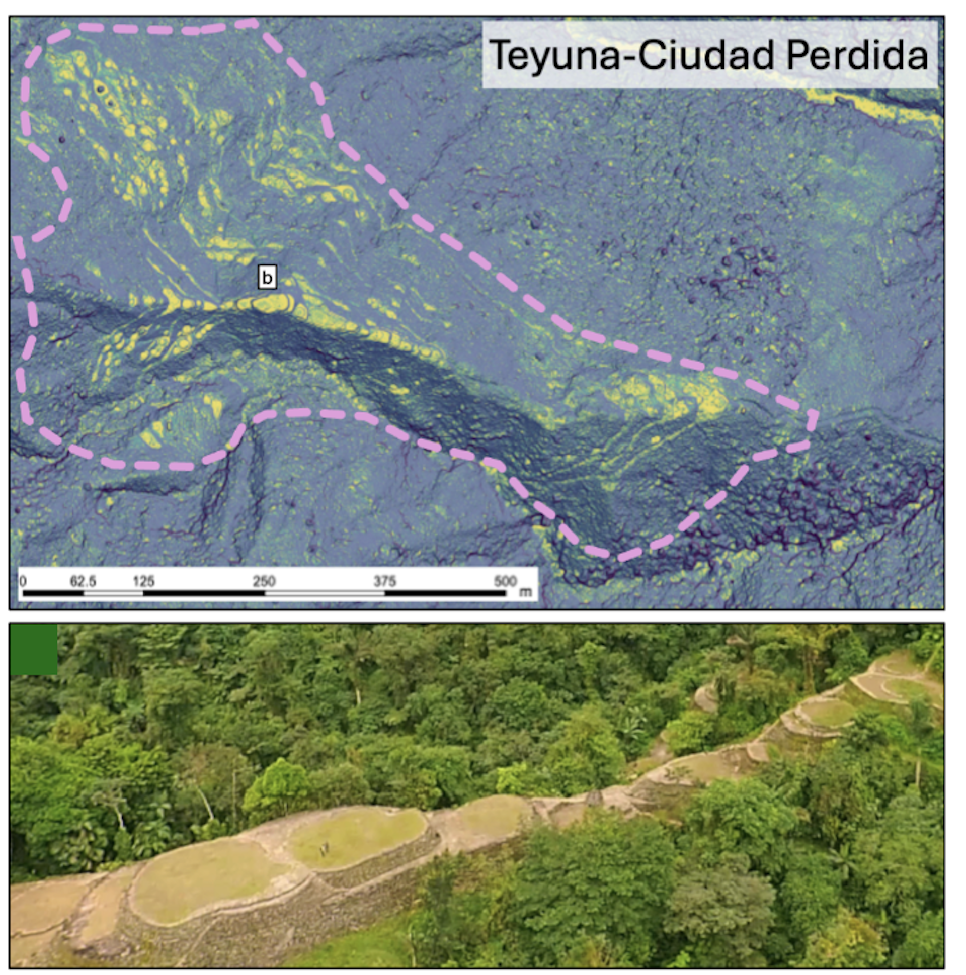
Further north, the Tairona people of the Sierra Nevada de Santa Marta in present-day Colombia built terraced stone towns in the mountains, linked by paved paths. This was a form of urbanism shaped entirely by the demands of steep, high-altitude terrain. Below is a lidar image of one area in this region, with the platforms that would have housed the settlements marked in yellow. Below that, you can see what the platforms look like.
在更北的地方,当今哥伦比亚的圣玛尔塔内华达山脉地区的泰罗纳人,在山地建造了梯田石城,并用铺砌的小路连接起来。这是一种完全由陡峭、高海拔地形需求所塑造的城市主义形式。下方是该地区一个区域的激光雷达图像,居住定居点的平台用黄色标记。再往下,您可以看到这些平台的具体样子。
In western Amazonia, Acre adds another important variation. From around AD1–1000, people built large ditched enclosures, or geoglyphs, mainly in the south-eastern part of this region along the upper Purus River. These were square, circular, hexagonal or octagonal mounds, often 1-3 hectares in size, with ditches up to four metres deep. These were probably used as ceremonial gathering places rather than permanent settlements.
在西部亚马逊地区,阿克州又增加了一种重要的变体。从公元元年到公元1000年左右,人们在该地区(主要位于上普鲁斯河的东南部)建造了大型壕沟围场,或称地画。这些是方形、圆形、六角形或八角形的土丘,面积通常为1至3公顷,壕沟深度可达四米。这些地方可能用作举行仪式的集会场所,而非永久定居点。
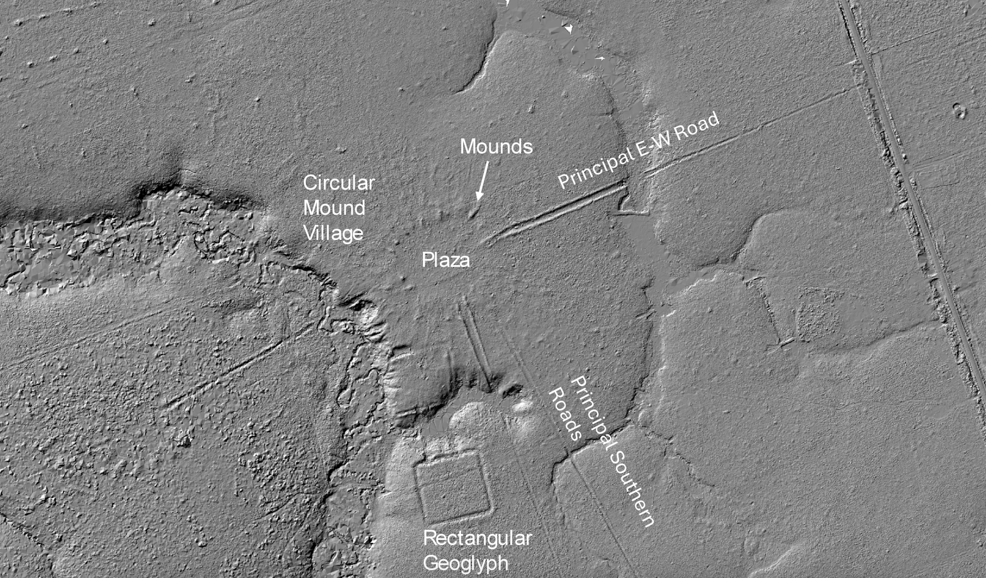
After about AD1000, these were followed by what we call circular mound villages, occupied until around AD 1650–1700. They featured rings of mounds around central plazas and straight roads radiating out like the rays of the Sun, often built to align with the four main compass points. These “Sun villages” were true settlements, and formed interconnected networks across the southern rim of Amazonia. You can see an example in the lidar image below.
大约公元1000年之后,接替的是我们所称的圆形土丘村落,这些村落有人居住直到大约公元1650年至1700年。它们以中央广场周围的土丘环和像太阳光芒一样辐射出去的直路为特色,通常建造时会与四个主要指南针方向对齐。这些“太阳村落”是真正的定居点,并在亚马逊南部边缘形成了相互连接的网络。您可以在下方的激光雷达(lidar)图像中看到一个例子。
Taken together, these discoveries fundamentally reshape our understanding of Amazonia. We now see a mosaic of managed landscapes, engineered environments and, in some cases, city-scale societies. What unites them is not a shared blueprint but a shared impulse: the organisation of people, space and movement across large landscapes in ways that were deliberate, durable and distinctly their own.
总的来说,这些发现从根本上重塑了我们对亚马逊地区的理解。我们现在看到的是一片由人工管理的景观、工程化的环境,在某些情况下甚至包括城市规模的社会。将它们联系起来的并非一个共同的设计蓝图,而是一种共同的冲动:即以一种经过深思熟虑、持久且具有自身特色的方式,组织人员、空间和流动于广阔的地域之中。
To stress, Amazonia was not uniformly dense or urban. It supported a diversity of types of settlements, from dispersed networks like Moxos to tighter grids like Upano, each of them adapted to local ecological conditions. They shared a low-density urbanism, in the sense of large, interconnected populations without the density of classic cities.
必须强调的是,亚马逊地区并非均匀密集或高度城市化的。它支持了各种类型的定居点,从像莫克索斯(Moxos)这样分散的网络到像乌帕诺(Upano)这样更紧密的网格,每种都适应了当地的生态条件。它们共享着一种低密度的“城市性”,指的是拥有大量相互关联的人口,但缺乏传统大都市的密集程度。
What we still don’t know
我们仍不知道的是
How were these societies organised politically and socially? How did they interact with variations in the climate and environment, ranging from the heavy rainfalls and droughts caused by El Niño to rivers forging new routes that could move them away from a settlement within a few generations?
这些社会在政治和社会上是如何组织的?它们如何与气候和环境的变化互动,从厄尔尼诺现象引起的暴雨和干旱,到河流在几代人内开辟新路线使他们远离定居点?
What, if any, connections existed with mountain societies in the Andes? And perhaps most importantly, since both the Casarabe and Upano ceased to build monuments after 1492, what led to their transformation or decline before the arrival of Europeans?
它们是否与安第斯山脉的社会存在任何联系?而也许最重要的是,由于卡萨拉贝(Casarabe)和乌帕诺(Upano)都于1492年之后停止建造纪念性建筑,是什么导致了他们在欧洲人到来之前发生了转变或衰落?
There is active debate between archaeologists over whether these societies transformed because of environmental stress, internal political change, or shifts in things like trade routes or migration.
考古学家们正在积极辩论这些社会是由于环境压力、内部政治变化,还是贸易路线或迁徙等因素的变动而发生转变的。
In the Llanos de Moxos, one possibility is that a prolonged period of climate change affected the Casarabe water-management systems that were so critical to feeding this thriving society. In the Upano Valley, volcanic eruptions and earthquakes may have disrupted settlements and agriculture, although it’s unclear whether that could have led to the area being abandoned.
在莫索斯平原(Llanos de Moxos),一种可能性是,一段长时间的气候变化影响了卡萨拉贝的水资源管理系统,而该系统对于养活这个繁荣的社会至关重要。在乌帕诺谷地,火山爆发和地震可能扰乱了定居点和农业,尽管尚不清楚这是否导致了该地区的废弃。
It seems likely that as we uncover new things, it will reveal more and more integration between different societies. What we are seeing now in Amazonia is much like looking at a satellite image of a country at night: bright, isolated clusters of light – cities that appear disconnected. But as we continue to expand our coverage and fill in the gaps, I think this will change.
似乎很可能的是,当我们发现更多东西时,它将揭示出不同社会之间越来越多的融合。我们现在在亚马逊地区看到的情况,就像看一张夜间国家的卫星图像:明亮的、孤立的光团——看似脱节的城市。但随着我们持续扩大覆盖范围并填补空白,我认为这种情况将会改变。
What now appear as isolated clusters may also resolve into extensive networks. For example a study across the southern rim of Amazonia has predicted that the kinds of settlement mounds that have been identified so far are likely to occur across about 400,000km², supporting an estimated regional population of roughly 500,000 to 1 million people in the era before the Europeans arrived.
目前看起来是孤立的集群,也可能演变成广阔的网络。例如,一项针对亚马逊南部边缘的研究预测,迄今发现的这类定居点土丘很可能分布在约40万平方公里的范围内,支持了欧洲人到来之前估计大约50万到100万人的区域人口。
Entire regions may emerge as previously unrecognised centres of population and landscape management. This could be particularly so for the Llanos de Moxos. The whole area covers as much as 200,000km², depending on where you draw the boundaries, stretching into Brazil and even Peru. It is often divided into several apparently distinct cultural regions — the Casarabe (aka the monumental mound region) , and then two others called the platform ridge and zanjas (ditches) regions.
整个地区可能会成为以前未被认识到的人口和景观管理中心。这对于莫索斯平原尤其如此。根据划定边界的位置不同,该整个区域面积高达20万平方公里,延伸至巴西甚至秘鲁。它通常被划分为几个看似独立的文化区域——卡萨拉贝(即纪念性土丘地区),以及另外两个被称为平台山脊和沟渠(zanjas)的地区。
As lidar coverage expands and more archaeological work is conducted, we may begin to understand how these societies were economically specialised. We know, for example, that the fortified villages of the zanjas region had fish weirs spanning hundreds of miles that were capable of capturing vast quantities of migratory fish. The platform ridge region consisted of large drained fields, which could potentially produce surpluses of maize. It is conceivable that these belonged to a broader network that supported the more complex Casarabe centres.
随着激光雷达(lidar)覆盖范围的扩大和更多考古工作的进行,我们可能会开始了解这些社会是如何实现经济专业化的。例如,我们知道沟渠地区的防御性村落拥有横跨数百英里的鱼堰,能够捕获大量的洄游鱼类。平台山脊地区则由大型排水田组成,理论上可以产生玉米盈余。可以想象的是,这些属于一个支持更复杂的卡萨拉贝中心的更广泛的网络。
Or perhaps – who knows – the relationships were more fluid and reciprocal. For now, the question remains open. But it is precisely this possibility of deep regional integration that lidar is beginning to bring into view. In time, we may even begin to identify Casarabe outposts scattered across the Llanos de Moxos.
或者——谁知道呢——这种关系更加流动和互惠。目前,这个问题仍然悬而未决。但正是这种深层次的区域融合的可能性,正在通过激光雷达技术逐渐显现出来。随着时间的推移,我们甚至可能会开始识别出散布在莫索斯平原各处的卡萨拉贝前哨站。
What happens next
将以下文本片段翻译成中文(简体- 中国大陆):
There’s still a huge amount to be done with lidar. Vast areas, particularly in the Ecuadorian and Peruvian Amazon – remain unexplored. One recent study suggested that there could be more than 10,000 more urban structures of the kind I’ve been describing still hidden throughout Amazonia, all of them dating from pre-European times.
目前,使用激光雷达(lidar)还有大量工作要做。亚马逊地区的大片区域,特别是在厄瓜多尔和秘鲁的亚马逊雨林,仍然是未被探索的。最近的一项研究表明,在整个亚马逊地区可能还隐藏着超过10,000个我所描述的类型的古代建筑结构,这些都可追溯到欧洲前时期。
Looking ahead 20 years, it is likely that our map of Amazonia will look very different. One promising technology is satellite-based lidar systems, which could provide broader, though less detailed, datasets across large areas. Advances in machine learning are also beginning to help us identify archaeological features within massive datasets, speeding up a labour-intensive process.
展望未来20年,我们对亚马逊地区的地图可能会发生巨大的变化。一种有前景的技术是基于卫星的激光雷达系统,它可以提供更广阔、尽管细节程度较低的大面积数据集。机器学习的进步也开始帮助我们在海量数据集中识别考古特征,从而加快了这项劳动密集型过程。
Against this, there are time pressures in some places. Llanos de Moxos, for instance, is unfortunately in rapid transition. The very ground that holds the traces of ancient networks is being transformed by mechanised agriculture and large-scale terraforming for rice cultivation and pastures.
然而,在某些地方存在时间压力。例如,莫克索斯平原(Llanos de Moxos)不幸正处于快速转型期。承载古代网络痕迹的土地本身,正在被机械化农业和大规模的稻米种植及牧场改造所改变。
We also need to keep reminding ourselves that lidar is only the first step. What really matters is how it’s brought together with other lines of evidence. Most sites discovered by lidar have yet to be excavated, so we’ll have to do much of that, looking for everything from bones and plants to ceramics and weapons.
我们还需要不断提醒自己,激光雷达只是第一步。真正重要的是如何将其与其他证据线索结合起来。迄今为止,通过激光雷达发现的大多数遗址尚未进行发掘,因此我们必须完成大部分的发掘工作,寻找从骨骼、植物到陶瓷和武器的一切物品。
So far, most excavation has been in the Casarabe area of the Llanos de Moxos. The reason, for instance, that we know the culture lived primarily on maize was through the discovery of over 60 human skeletons, which underwent carbon isotope analysis. The same research paper also analysed excavated duck bones to show that the Casarabe were feeding them maize too, suggesting animal domestication in a continent that was not generally known for it.
到目前为止,大多数的考古发掘都在莫克索斯平原的卡萨拉贝(Casarabe)地区。例如,我们知道该文化主要以玉米为生,是通过对超过60具人类骨骼进行的碳同位素分析得出的结论。同一篇研究论文还分析了出土的鸭骨,表明卡萨拉贝人也喂养它们玉米,这暗示着在一个通常不以驯化动物闻名的大陆上发生了动物驯化。
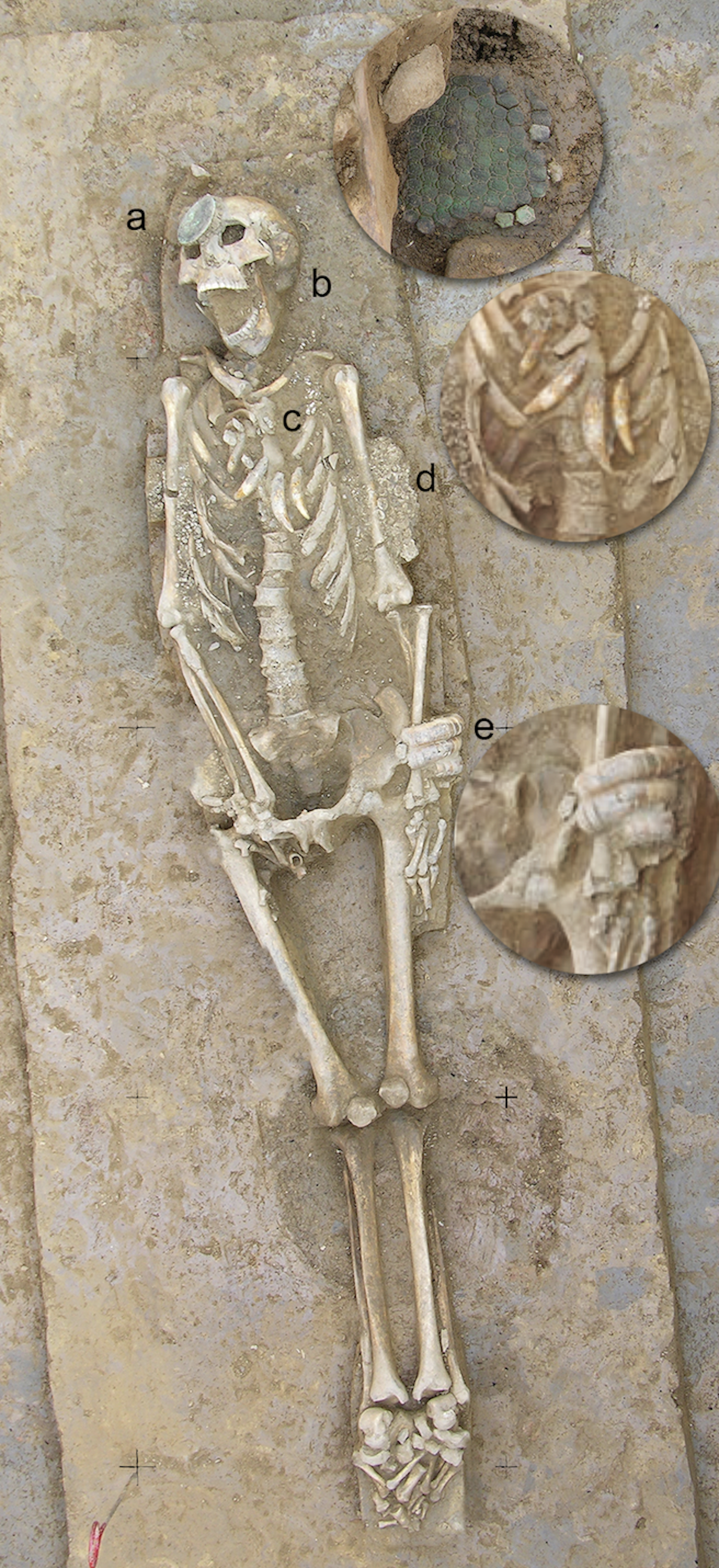
Another fascinating Casarabe find is a single buried skeleton who may have been a leader, because he had a collar of jaguar teeth around his neck. He was also wearing ear pieces made of armadillo shell, studded with mottled blue stones called sodalite – it’s not clear what these were for.
另一个引人入胜的卡萨拉贝发现是一具可能属于领袖的埋葬骨骼,因为他的脖子上戴着一个由美洲豹牙组成的项圈。他还佩戴着由岩壳制成的耳饰,上面镶嵌着一种被称为蓝晶石(sodalite)的斑驳蓝色石头——这些物品的作用尚不清楚。
We’ll also need to obtain more precise dates for key events using techniques like radiocarbon dating, and more pinpoint accurate environmental data to help support theories about ancient changes to the climate – as opposed to the wider regional information we’ve tended to rely on until now. Lake sediments are great environmental archives, preserving evidence of things like vegetation change and landscape disturbance.
我们还需要利用放射性碳定年等技术,为关键事件获取更精确的日期,并获得更准确的环境数据来支持关于古代气候变化的理论——而不是像以前那样依赖于更广泛的区域信息。湖泊沉积物是极好的环境档案,可以保存植被变化和景观干扰等证据。
Also important is comparing genetic data from excavated bones with people who live in these areas today – in dialogue and collaboration with local communities whose histories, memories and knowledge are essential to understanding these landscapes.
同样重要的是将发掘骨骼的基因数据与今天生活在这些地区的居民进行比较——这需要与当地社区进行对话和合作,因为他们的历史、记忆和知识对于理解这些景观至关重要。
It’s all a question of how lidar is brought together with all this other evidence. The most convincing reconstructions will come from the convergence of all of these. One further major challenge ahead, however, will be to bridge the gap between scientific reconstructions and how past peoples understood and inhabited their world. Archaeology is increasingly rich in data, but we have to relate it to lived experience.
这一切都取决于如何将激光雷达与其他所有证据结合起来。最令人信服的重建结果将来自于所有这些元素的汇合。然而,未来另一个主要的挑战是弥合科学重建与古代人民如何理解和居住其世界之间的鸿沟。考古学数据日益丰富,但我们必须将其与生活经验联系起来。
That is no easy feat, but it is essential if we are to move from mapping past worlds to understanding them. Crucially, Amazonia – with its rich, still-vibrant Indigenous societies and ethnographic record – offers an exceptional opportunity to do this, providing rare continuities through which to anchor and critically engage our interpretations of the past.
这不是一件容易的事,但如果我们要从绘制过去的图景走向理解过去,这一点至关重要。关键在于,亚马逊地区——凭借其丰富、仍然充满活力的原住民社会和民族志记录——提供了一个绝佳的机会来做到这一点,提供了罕见的连续性,使我们能够锚定并批判性地参与对过去的解读。
Lessons for today
今天的经验教训
My own sense is that we will move towards a view of Amazonia not as an exception, in line with the old view that the people lived within an untouched paradise, but as part of a broader pattern of human-environment interaction. The rainforest will be understood not only as a biological system, but as a historical one – shaped, in part, by the people who lived within it.
我个人认为,我们将逐渐转变对亚马逊地区的看法,不再将其视为一个例外——不能沿用“人类生活在未受破坏的伊甸园”这种旧观念,而是将其视为人与环境互动更宏大模式的一部分。热带雨林将被理解为一个不仅是生物系统,也是历史系统——部分地由居住其中的人民塑造而成。
This does not mean the Amazonian people who simply lived “in harmony” with nature; the evidence points to something more interesting. Although Amazonian societies developed complex, and at times intensive, forms of land use, the evidence consistently shows that they often did so while maintaining continuous forest cover. Far from the large-scale deforestation that we might assume was necessary for such elaborate forms of human life, their practices created mosaics of managed forest, gardens, orchards, wetlands and settlement areas.
这并不意味着亚马逊原住民只是简单地与自然“和谐相处”;证据指向了更引人入胜的东西。尽管亚马逊社会发展出复杂、有时甚至是密集的土地利用形式,但证据一致表明,他们往往在维持连续森林覆盖的同时进行这些活动。他们的实践创造了经过管理的森林、花园、果园、湿地和定居点等马赛克景观,这与我们可能假设为了如此精巧的人类生活方式所必需的大规模砍伐森林的做法相去甚远。
We know partly from lake sediment data that people enriched the forests with species that provided food, building materials, medicines and other resources, from açaí and cacao to palms, cinchona and copaiba. The fact that some of these species endure today suggests that past land use left lasting ecological legacies.
我们部分地从湖泊沉积物数据得知,人们用提供食物、建筑材料、药物和其他资源的物种丰富了森林,这些资源包括巴西莓和可可,以及棕榈树、金鸡纳树和科帕伊巴木等。一些物种至今仍然存在的事实表明,过去的土地利用留下了持久的生态遗产。
In the context of today’s climate crisis, the long-term balance that these people achieved offers a powerful lesson: it is possible to sustain complex societies without destroying the forest, if land use is guided by principles that integrate ecological knowledge, cultural values and a commitment to the continuity of the living landscape.
在当今气候危机的背景下,这些人民所实现的长期平衡提供了一个强有力的教训:如果土地利用遵循整合了生态知识、文化价值观和对活态景观连续性承诺的原则进行指导,那么就有可能在不破坏森林的情况下维持复杂的社会。
What lies beneath the Amazon is not just a hidden past. It is a reminder that even the most seemingly untouched landscapes can carry deep histories, waiting – sometimes just beneath our feet – to be revealed.
亚马逊之下不仅仅是一个隐藏的过去。它提醒我们,即使是最看似未受触动的景观,也可能承载着深厚的历史,等待着——有时就在我们的脚下——被揭示出来。
This article features references to books that have been included for editorial reasons, and may contain links to bookshop.org. If you click on one of the links and go on to buy something from bookshop.org The Conversation UK may earn a commission.
本文包含了一些出于编辑原因引用的书籍,其中可能包含指向bookshop.org的链接。如果您点击了其中任何一个链接并在bookshop.org购买了商品,The Conversation UK可能会获得佣金。
For you: more from our Insights series:
为您推荐:更多来自我们的《洞察》系列文章:
Underground data fortresses: the nuclear bunkers, mines and mountains being transformed to protect our ‘new gold’ from attack
地下数据堡垒:为保护我们的“新黄金”,核掩体、矿井和山脉正在经历的改造
‘People think you come out … and live happily ever after. If only.’ The reality of life after wrongful conviction
“人们以为你出来……就会幸福地生活下去。要是能这样就好了。”错判刑后生活的真实写照
The grief myth: it doesn’t come in stages or follow a checklist – like love, it endures
悲伤神话:它不是分阶段发生的,也不是遵循清单——就像爱一样,它会持续存在
Inside Porton Down: what I learned during three years at the UK’s most secretive chemical weapons laboratory
深入波顿下基地:我在英国最秘密化学武器实验室度过的三年中学到了什么
To hear about new Insights articles, join the hundreds of thousands of people who value The Conversation’s evidence-based news. Subscribe to our newsletter.
如需了解新的《洞察》文章,请加入成千上万珍视The Conversation循证新闻的人群。订阅我们的电子报。
José Iriarte receives funding from the European Research Council, the Arts and Humanities Research Council, the British Academy, National Geographic and the Wenner-Gren Foundation for Anthropological Research.
José Iriarte获得了欧洲研究理事会、艺术与人文研究委员会、英国学院、国家地理学会和温纳-格伦人类学研究基金会的资助。

