
أسرار عظيمة في علم الآثار: عالم أمازون القديم يُكشف عنه من السماء
Great mysteries of archaeology: an ancient Amazonian world revealed from the sky
Archaeologists thought ancient Amazonia was only home to wandering people, but new technology has uncovered complex societies living in forest cities.
ظن علماء الآثار أن أمازونيا القديمة كانت موطناً للرحالة فقط، لكن التقنيات الحديثة كشفت عن مجتمعات معقدة تعيش في مدن داخل الغابات.
From the air, you see it only through the constant jolt, tilt and shudder of the low-flying Cessna aircraft. The landscape of the Llanos de Moxos, northern Bolivia, appears as a disconnected patchwork of open grassland savannahs, forest islands and lakes.
من الجو، لا تراه إلا من خلال الاهتزاز والميل والرجفة المستمرة لطائرة سيسنا التي تحلق على ارتفاع منخفض. يظهر مشهد لـ “لانيوس دي موكسوس” في شمال بوليفيا كفسيفساء غير متصلة من السافانا العشبية المفتوحة، وجزر الغابات، والبحيرات.
It feels random, almost unreadable. Only gradually does the pattern resolve itself: raised causeways or paths fanning out to link the forest islands, and a dense, scattered web of canals threading the terrain. Slowly you realise it’s a structured network of intersecting lines, enclosures and roads – the imprint of past human design.
يبدو الأمر عشوائياً، ويكاد يكون غير قابل للقراءة. ولا يتضح النمط إلا تدريجياً: جسور أو مسارات مرتفعة تتفرع لربط جزر الغابات، وشبكة كثيفة ومبعثرة من القنوات تعبر التضاريس. ببطء تدرك أنها شبكة منظمة من الخطوط المتقاطعة والمساكن والطرق – بصمة التصميم البشري الماضي.
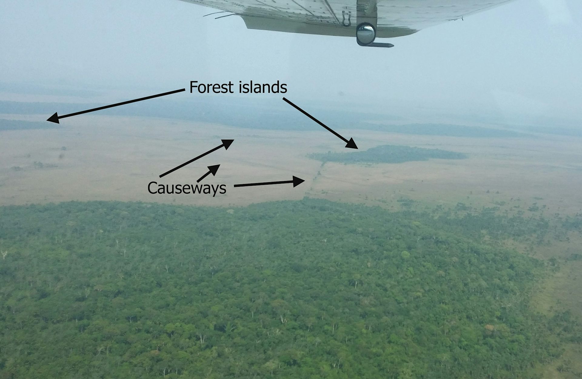
If you stand on the open savannah, there is almost nothing to see of this ancient network. The horizon feels open, with fires in the distance from local people burning pastures and clearing forest as dry season begins. The old geometry is still faintly perceptible, but you have to know how to look.
إذا وقفت في السافانا المفتوحة، فبالكاد تجد شيئاً من هذه الشبكة القديمة. يبدو الأفق مفتوحاً، مع وجود نيران في المسافة من السكان المحليين الذين يحرقون المراعي ويقومون بتطهير الغابات مع بدء موسم الجفاف. لا تزال الهندسة القديمة محسوسة بشكل خافت، ولكن عليك أن تعرف كيف تنظر.
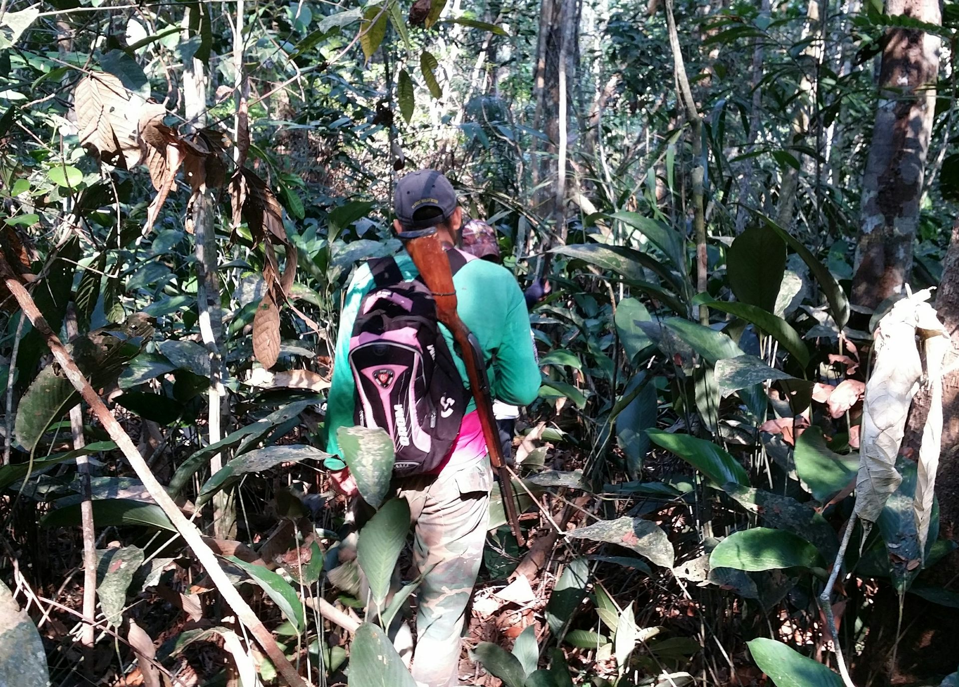
Step into the patches of forest and the canopy closes in. The earth softens underfoot and mosquitoes descend in relentless swarms. The sweat on your neck thickens into a humid film, carrying the familiar scent of suncream and the sharper, chemical note of DEET.
ادخل إلى بقع الغابة وينغلق الظل فوقك. تصبح الأرض ناعمة تحت قدميك وتنزّل البعوض في أسراب لا هوادة فيها. يتكاثف العرق على رقبتك ليصبح غشاءً رطباً، يحمل الرائحة المألوفة لكريم الشمس والملاحظة الكيميائية الأكثر حدة لمادة DEET.
In the uneven light between the trees, the landscape dissolves into subtle rises and depressions. Against the rhythmic swish of machetes as our guides cut through the vegetation, your mind tries to piece together the fragments of structures into something coherent. Flying overhead doesn’t reveal anything about this forest area in the way that it does with the savannah. But fortunately recent advances in technology have transformed what we are able to see.
في الضوء غير المتساوي بين الأشجار، يذوب المشهد في ارتفاعات وانخفاضات خفية. مقابل حفيف المنجل الإيقاعي بينما يقوم مرشدونا بالقطع عبر الغطاء النباتي، يحاول عقلك تجميع شظايا الهياكل لتكوين شيء متماسك. الطيران من الأعلى لا يكشف شيئاً عن منطقة الغابات هذه بالطريقة التي يفعلها مع السافانا. ولكن لحسن الحظ، أدت التطورات الحديثة في التكنولوجيا إلى تغيير ما يمكننا رؤيته.
Archaeological explorations in this part of the world have been completely changed by lidar in the past couple of decades. Lidar maps an area from a plane or drone by bouncing rapid laser pulses off the Earth’s surface. Some of these pulses penetrate the forest canopy, reach the ground and reflect back to the sensor.
لقد تغيرت الاستكشافات الأثرية في هذا الجزء من العالم بالكامل بفضل تقنية الليدار (Lidar) خلال العقدين الماضيين. يقوم الليدار برسم خرائط لمنطقة ما من طائرة أو طائرة بدون طيار عن طريق ارتداد نبضات ليزر سريعة عن سطح الأرض. تخترق بعض هذه النبضات غطاء الغابة، وتصل إلى الأرض وتنعكس مرة أخرى على المستشعر.
By measuring the return time, the system can generate highly precise three-dimensional models of the terrain. This allows you to strip away the camouflage of vegetation, making it possible to see what lies below the Amazonian forest for the first time.
من خلال قياس وقت العودة، يمكن للنظام إنشاء نماذج ثلاثية الأبعاد عالية الدقة للتضاريس. وهذا يسمح لك بإزالة تمويه الغطاء النباتي، مما يجعل من الممكن رؤية ما يكمن تحت غابات الأمازون للمرة الأولى.
It reveals the ancient Llanos de Moxos as not simply a collection of settlements, but an entire urbanised landscape. A large part in the south-east of this region belonged to the Casarabe culture, which dominated between around AD500 and 1400. It extends across 20,000km², which is roughly the size of New Jersey in the US.
يكشف عن “لانيوس دي موكسوس” القديمة ليس مجرد مجموعة مستوطنات، بل مشهداً حضرياً كاملاً. كانت منطقة كبيرة في جنوب شرق هذه المنطقة تابعة لثقافة الكاسارابي (Casarabe) ، التي هيمنت بين حوالي عام 500 و 1400 ميلادية. وتمتد على مساحة 20,000 كيلومتر مربع، وهي تقريباً بحجم نيوجيرسي في الولايات المتحدة.
The Casarabe organised into a hierarchy of four different sizes of settlements (those forest islands mentioned above) . The biggest ones – the primary settlements – were as large as 3km² or 300 hectares. That’s enough space for over 400 football pitches, suggesting that they could have accommodated substantial numbers of people.
نظّم الكاسارابيون أنفسهم ضمن تسلسل هرمي لأربع أحجام مختلفة من المستوطنات (تلك الجزر الغابية المذكورة أعلاه) . كانت الأكبر – المستوطنات الأساسية – تصل مساحتها إلى 3 كيلومترات مربعة أو 300 هكتار. وهي مساحة كافية لأكثر من 400 ملعب كرة قدم، مما يشير إلى أنها كانت قادرة على استيعاب أعداد كبيرة من السكان.
Welcome to our series on the great mysteries of archaeology. Viking explorers, Amazonian cities, artefacts from before civilisation. Archaeology may be all about the past, but it’s constantly shifting with every scientific discovery. This series will dig into some of the most fascinating debates in the field today.
مرحباً بكم في سلسلتنا عن الأسرار العظيمة لعلم الآثار. المستكشفون الفايكنج، مدن الأمازون، والتحف التي تعود إلى ما قبل الحضارة. قد يكون علم الآثار كله يتعلق بالماضي، ولكنه يتغير باستمرار مع كل اكتشاف علمي. ستتعمق هذه السلسلة في بعض النقاشات الأكثر إثارة للاهتمام في هذا المجال اليوم.
These settlements connect along the raised causeways to smaller secondary and tertiary sites a number of kilometres away, all of which were permanently inhabited as opposed to empty ceremonial hubs. A fourth tier consists of groups of isolated mounds located out in the pampas, which likely correspond to dwelling areas occupied by farmers who would have worked the fields.
ترتبط هذه المستوطنات عبر الجسور المرتفعة بمواقع ثانوية وثالثية أصغر تبعد عدة كيلومترات، وكلها كانت مأهولة بشكل دائم على عكس المراكز الاحتفالية الفارغة. وتتكون الفئة الرابعة من مجموعات التلال المعزولة الواقعة في السافانا، والتي يُحتمل أنها تتوافق مع مناطق سكنية شغلها المزارعون الذين كانوا يعملون في الحقول.
It’s not possible to show a lidar image of these four different types of sites interconnecting because they are too far apart for the resolution available, but the image below of a primary settlement known as Loma Cotoca shows the kinds of things we are now documenting.
ليس من الممكن عرض صورة ليدار لهذه الأنواع الأربعة المختلفة من المواقع وهي متصلة لأنها بعيدة جداً عن بعضها البعض بالنسبة للدقة المتوفرة، ولكن الصورة أدناه لمستوطنة أساسية تُعرف باسم “لوما كوتوكا” تظهر أنواع الأشياء التي نوثقها الآن.
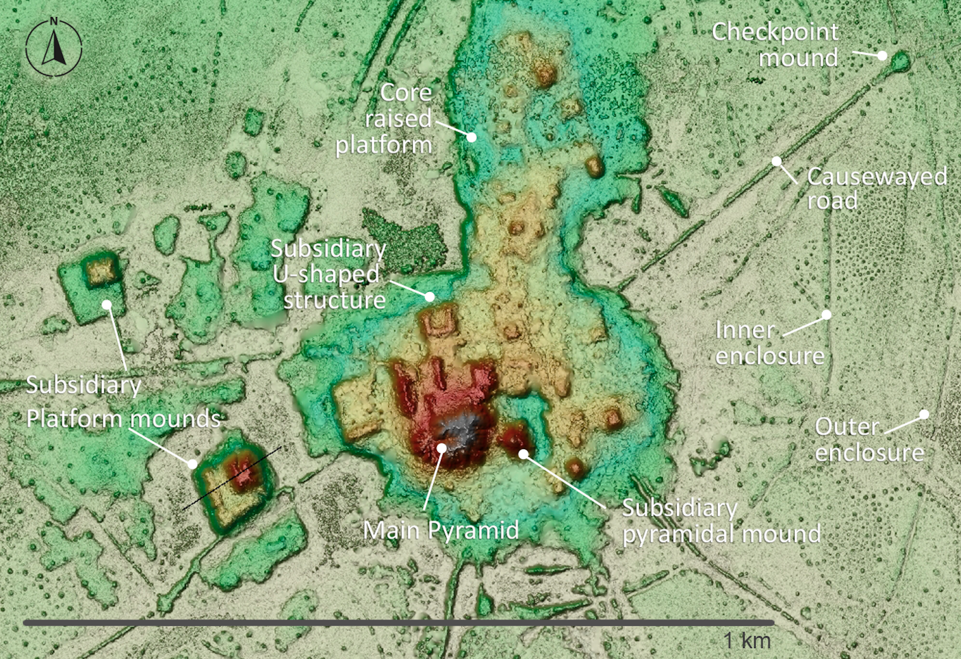
It features some very impressive civic-ceremonial architecture: conical pyramids over 20 metres tall and U-shaped structures that may have acted as areas for public gatherings for speeches or ceremonies. These were built on top of man-made platforms rising as much as five metres off the ground and extending over 20 hectares. To be clear, this is all still hiding under the forest, but the lidar data reveals the shape, height and layout of what lies below.
يتميز بمجموعة من العمارة المدنية الاحتفالية المذهلة: أهرامات مخروطية يزيد ارتفاعها عن 20 متراً وهياكل على شكل حرف U ربما كانت تعمل كمناطق للتجمعات العامة للخطابات أو الاحتفالات. وقد بُنيت هذه الهياكل فوق منصات اصطناعية ترتفع بما يصل إلى خمسة أمتار عن الأرض وتمتد على مساحة تتجاوز العشرين هكتاراً. وللتوضيح، كل هذا لا يزال مخبأً تحت الغابة، لكن بيانات الليدار تكشف عن شكل وارتفاع وتخطيط ما يكمن في الأسفل.
The volume of earth moved to create this architecture would have rivalled – and in some cases exceeded – that of well known Andean monuments such as Akapana a few hundred miles to the south-west on the other side of the Andes. Akapana was the epicentre of the Tiwanaku empire that dominated the southern Andes between about AD600 and 1000.
إن حجم التربة التي نُقلت لإنشاء هذا الصرح المعماري كان ليضاهي- وفي بعض الحالات يتجاوز- حجم الآثار الأنديزية المعروفة مثل أكابانا، الواقعة على بعد بضع مئات من الأميال إلى الجنوب الغربي في الجانب الآخر من جبال الأنديز. كانت أكابانا هي المركز الرئيسي لإمبراطورية تيواناكو التي سيطرت على الأنديز الجنوبية في الفترة ما بين حوالي عام 600 و 1000 ميلادية.
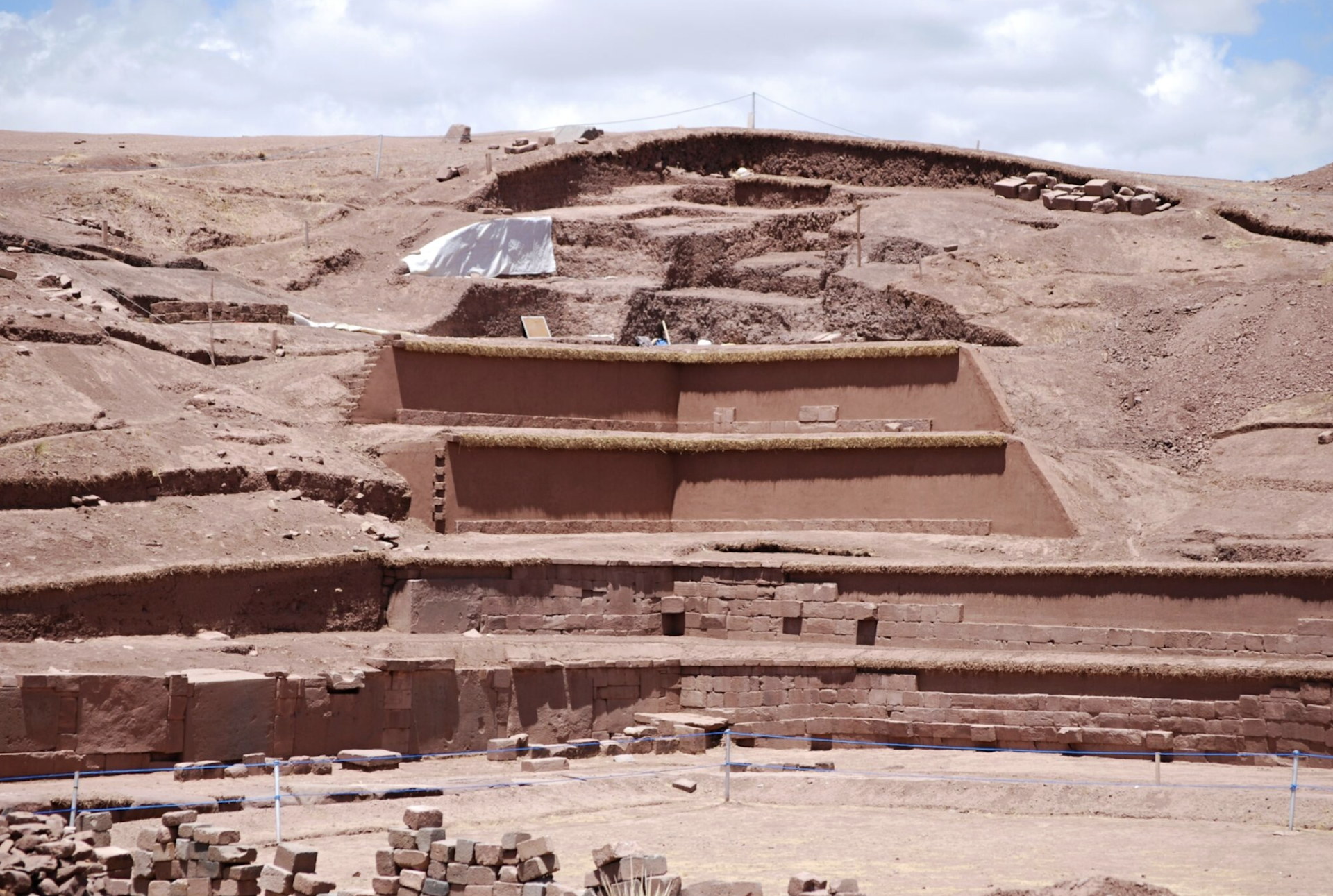
Yet where monuments like Akapana were surrounded by classic, compact bounded cities with thousands of inhabitants, the Casarabe equivalent was completely different. This was dispersed, low-density living amid extensive green space – a form of tropical urbanism that challenges longstanding assumptions about this area as sparsely populated and only lightly modified. It invites comparison with other low-density tropical urban landscapes such as the Maya in central America and the Angkor in latter day Cambodia.
ومع ذلك، فبينما كانت المعالم الأثرية مثل أكابانا محاطة بمدن مكتظة ومحددة الكلاسيكية التي تضم آلاف السكان، كان ما يعادلها في كازارابي مختلفًا تمامًا. لقد كان هذا نمط حياة مبعثر ومنخفض الكثافة وسط مساحات خضراء واسعة – وهو شكل من أشكال التخطيط الحضري الاستوائي يتحدى الافتراضات القديمة حول هذه المنطقة بأنها قليلة السكان ومعدّلة بشكل طفيف فقط. ويدعو ذلك إلى المقارنة مع المناظر الحضرية الاستوائية الأخرى ذات الكثافة المنخفضة، مثل حضارة المايا في أمريكا الوسطى وأنغكور في كمبوديا الحديثة.
Equally important is the coherence of the Casarabe system. The settlements are rarely isolated, part of a tightly connected network with shared water-management systems. It was clearly all planned and coordinated, designed not only as living spaces but for integrating the population across the region.
ويعد تماسك نظام القصارابة ذا أهمية متساوية. نادرًا ما كانت المستوطنات معزولة، بل كانت جزءًا من شبكة مترابطة بإحكام ذات أنظمة إدارة مياه مشتركة. ومن الواضح أنه كان مخططًا ومنسقًا بالكامل، ولم يُصمَّم فقط كمساحات سكنية، بل لدمج السكان في جميع أنحاء المنطقة.
We can see that the Casarabe were sustained by drained-field agriculture: the canals were dug to make the land viable for planting during the wet season. The most prominent crop was maize, but there was a remarkable diversity of other produce. This was all embedded within a landscape that was engineered through reservoirs and farm ponds, which helped the Casarabe sustain cultivation and maintain access to water through the dry season in this extremely seasonal environment.
يتضح أن الكاسارابي اعتمدوا على الزراعة في الحقول المستصلحة؛ حيث حُفرت القنوات لجعل الأرض صالحة للزراعة خلال الموسم الرطب. وكان المحصول الأبرز هو الذرة، ولكن كان هناك تنوع ملحوظ من المنتجات الأخرى. وكل هذا كان مدمجاً ضمن مشهد طبيعي تم هندسته عبر الخزانات والبرك الزراعية، مما ساعد الكاسارابي على استدامة الزراعة والحفاظ على الوصول إلى المياه خلال الموسم الجاف في هذه البيئة الموسمية للغاية.
Also very noticeable is the fact that all the major architectural features and burial sites are oriented north-north-west. This suggests these people may have been led by cosmology, with important celestial bodies or regions of the night sky serving as symbolic reference points – hinting at a world where infrastructure, settlement and belief were inseparable.
ويُلاحظ أيضاً أن جميع المعالم المعمارية الرئيسية ومواقع الدفن موجهة نحو الشمال الغربي الشمالي. وهذا يشير إلى أن هؤلاء الناس ربما كانوا يسترشدون بعلم الكونيات، حيث عملت الأجرام السماوية المهمة أو مناطق سماء الليل كنقاط مرجعية رمزية – مما يلمح إلى عالم كانت فيه البنية التحتية والاستيطان والمعتقدات غير قابلة للفصل.
Rethinking the Amazon
إعادة التفكير في الأمازون
The Casarabe culture covered much less than 1% of Amazonia, which is the whole tropical interior of South America, spanning close to half of the entire continent. For much of the 20th century, this vast area was viewed by archaeologists as an environment that was limiting for human existence.
غطت ثقافة الكاسارابي جزءاً أقل بكثير من 1% من منطقة أمازونيا، وهي الباطن الاستوائي بأكمله لأمريكا الجنوبية، ويمتد لتغطي ما يقرب من نصف القارة بأكملها. وخلال معظم القرن العشرين، نظر علماء الآثار إلى هذه المنطقة الشاسعة على أنها بيئة مقيدة للوجود البشري.
Poor soils, scarce game, extreme El Niño floods and droughts, and the challenges of tropical disease were all thought to constrain human populations to small, wandering groups living off the land as best they could. Large, settled societies – let alone towns or cities – were considered unlikely, if not impossible.
كان يُعتقد أن التربة الفقيرة، والحيوانات النادرة، وفيضانات وجفاف ظاهرة النينيو الاستوائية القاسية، وتحديات الأمراض المدارية، كلها عوامل تقيد التجمعات البشرية إلى مجموعات صغيرة متنقلة تعيش على الأرض قدر استطاعتها. واعتُبرت المجتمعات الكبيرة المستقرة – ناهيك عن المدن أو البلدات – أمرًا مستبعدًا، إن لم يكن مستحيلاً.
This view began to shift in the late 20th century for several reasons. Archaeologists realised that Amazonian people had been domesticating a diversity of plants since the end of the Ice Age. They manufactured some of the earliest ceramics in the Americas, and also devised soils known as Amazonian Dark Earths, which combined charcoal, bone and waste materials with the existing poor-quality soil to make it fertile enough for widespread farming.
بدأ هذا المنظور يتغير في أواخر القرن العشرين لعدة أسباب. وأدرك علماء الآثار أن سكان الأمازون كانوا يقومون بتدجين مجموعة متنوعة من النباتات منذ نهاية العصر الجليدي. وقد قاموا بصناعة بعض من أوائل السيراميك في الأمريكتين، كما ابتكروا تربة تُعرف باسم “التربة الداكنة الأمازونية”، والتي جمعت الفحم والعظام والمخلفات مع التربة الفقيرة الموجودة لجعلها خصبة بما يكفي للزراعة الواسعة النطاق.
It also became apparent that just like the Casarabe people, many other cultures across Amazonia had reclaimed vast expanses of seasonally flooded savannahs over several thousand years to create raised and drained field systems.
كما أصبح من الواضح أنه، تماماً مثل شعب الكاسارابي، كانت العديد من الثقافات الأخرى في جميع أنحاء أمازونيا قد استعادت مساحات شاسعة من السافانا المغمورة موسمياً على مدى آلاف السنين لإنشاء أنظمة حقول مرتفعة ومصرفة.
These discoveries were evidence of long-term settlement and landscape management far beyond what was previously thought possible. It meant Amazonia was not simply a backdrop to human activity; much of the landscape was shaped over the last 13 millennia by the people who lived there.
كانت هذه الاكتشافات دليلاً على الاستيطان طويل الأمد وإدارة المناظر الطبيعية بما يتجاوز بكثير ما كان يُعتقد أنه ممكن سابقاً. وهذا يعني أن أمازونيا لم تكن مجرد خلفية للنشاط البشري؛ بل إن جزءاً كبيراً من المشهد قد تشكّل على مدى الـ 13 ألف عام الماضية بواسطة الأشخاص الذين عاشوا هناك.
Enter lidar
ادخل ليدار
Like lasers in the sky, lidar technology has accelerated this transformation in our understanding. The digital process feels near-magical, a “vegetation removal algorithm” that reveals the secrets below.
مثل الليزرات في السماء، سرّع نظام الليدار هذا التحول في فهمنا. تبدو العملية الرقمية شبه سحرية، وهي “خوارزمية إزالة الغطاء النباتي” التي تكشف الأسرار الكامنة بالأسفل.
In practice, however, working with lidar in Amazonia is anything but straightforward. Running such a project here, as I have done, can feel like one of the greatest emotional rollercoasters in field archaeology. It’s all anticipation, frustration and sudden revelation – only comparable, perhaps, with shipwreck exploration.
لكن عملياً، فإن العمل باستخدام الليدار في منطقة أمازونيا ليس بالأمر السهل على الإطلاق. إن تنفيذ مثل هذا المشروع هنا، كما فعلت أنا، يمكن أن يشبه أحد أضخم الأفعوانيات العاطفية في علم الآثار الميداني. إنه مزيج من الترقب والإحباط والكشف المفاجئ – لا يقل ربما عن استكشاف حطام السفن.
Depending on what technology is available and most suitable for exploring a particular area, I’ve worked with lidar attached to drones, aeroplanes and helicopters. I’ve learned through trial and error that the technology is only as effective as the logistics and personalities behind it – above all on one occasion when we were trying to integrate a Hungarian lidar sensor with a Brazilian drone.
اعتماداً على التقنية المتوفرة والأكثر ملاءمة لاستكشاف منطقة معينة، عملت باستخدام الليدار المثبت على الطائرات بدون طيار (الدرونز) ، والطائرات النفاثة، والمروحيات. تعلمت من التجربة والخطأ أن هذه التكنولوجيا لا تكون فعالة إلا بقدر ما توفره الخدمات اللوجستية والشخصيات الكامنة وراءها – خاصة في مناسبة واحدة كنا نحاول فيها دمج مستشعر ليدار هنجاري مع طائرة بدون طيار برازيلية.
Lidar can perform beautifully one day and fail the next, depending on the equipment, weather, terrain, batteries, communications and the sheer difficulty of operating in remote Amazonian conditions.
يمكن أن يعمل الليدار بشكل ممتاز يوماً ويفشل في اليوم التالي، اعتماداً على المعدات والطقس والتضاريس والبطاريات والاتصالات والصعوبة المطلقة للعمل في الظروف النائية لأمازونيا.
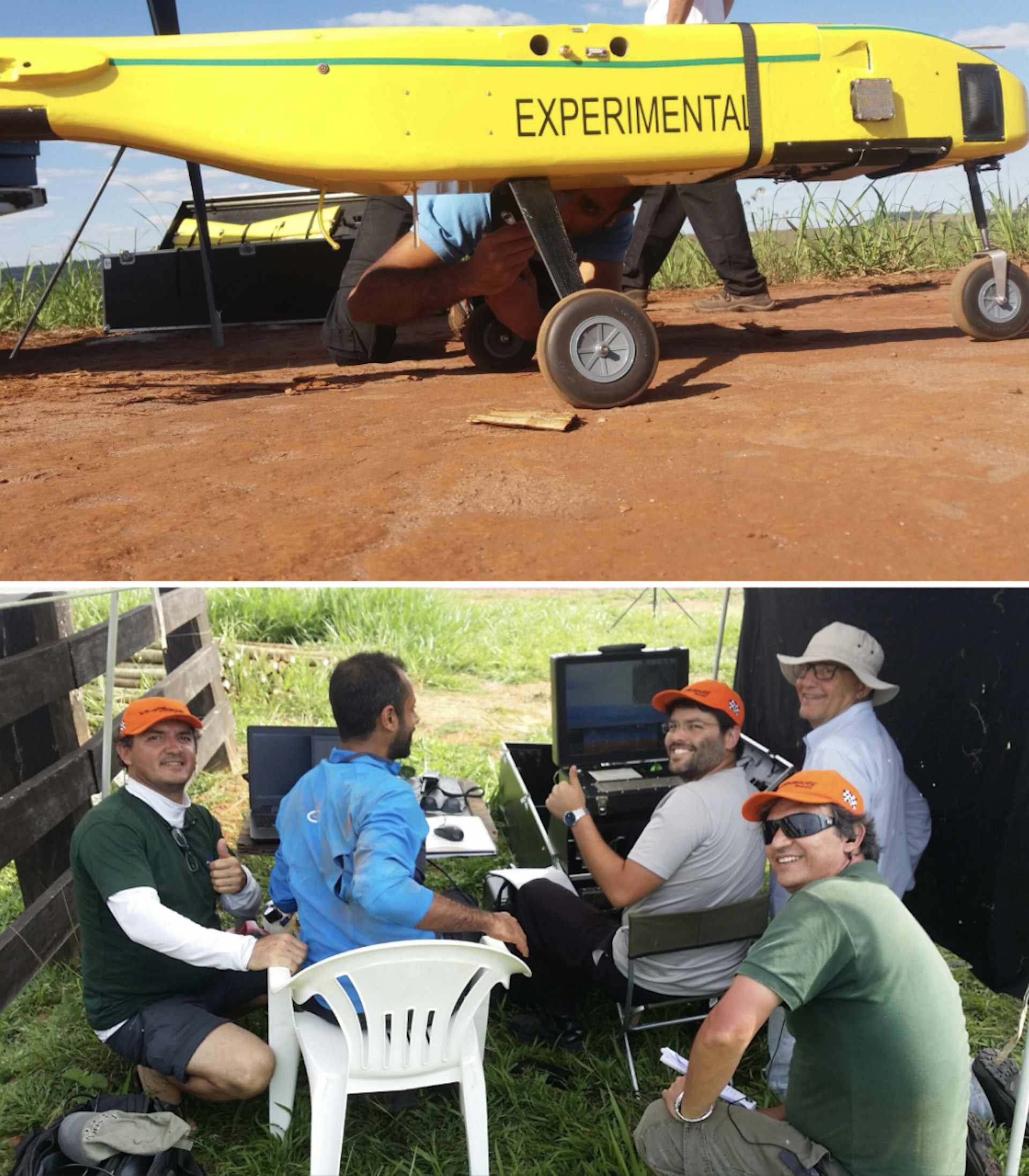
Flights must be carefully planned in remote areas with limited infrastructure, where convective clouds, smoke from fires, wind and even vultures riding thermals can disrupt data acquisition. You have to arrange fuel in advance and improvise landings wherever a safe clearing can be found. Here’s our team refuelling a lidar helicopter in the football field of a small village in Acre state, western Brazil:
يجب التخطيط للطيران بعناية في المناطق النائية ذات البنية التحتية المحدودة، حيث يمكن أن تعرقل السحب الحملية والدخان الناتج عن الحرائق والرياح وحتى النسور التي تحلق بالتيارات الهوائية عملية الحصول على البيانات. يجب ترتيب الوقود مسبقاً وتدبير أماكن الهبوط في أي مساحة خالية آمنة يمكن العثور عليها. إليكم فريقنا وهو يعيد تزويد مروحية ليدار بالوقود في ملعب كرة قدم لقرية صغيرة في ولاية أكري، غرب البرازيل:
You also have to do constant troubleshooting with the technology, such as making sure it’s calibrated correctly and that the data from different flight paths all aligns. What appears in the final images as a seamless “removal” of the forest is, in reality, the product of improvisation, negotiation and persistence.
عليك أيضاً إجراء استكشاف مستمر للمشاكل التقنية، مثل التأكد من معايرته بشكل صحيح وأن البيانات الواردة من مسارات طيران مختلفة تتطابق جميعها. ما يظهر في الصور النهائية على أنه “إزالة” سلسة للغابة هو، في الواقع، نتاج الارتجال والتفاوض والمثابرة.
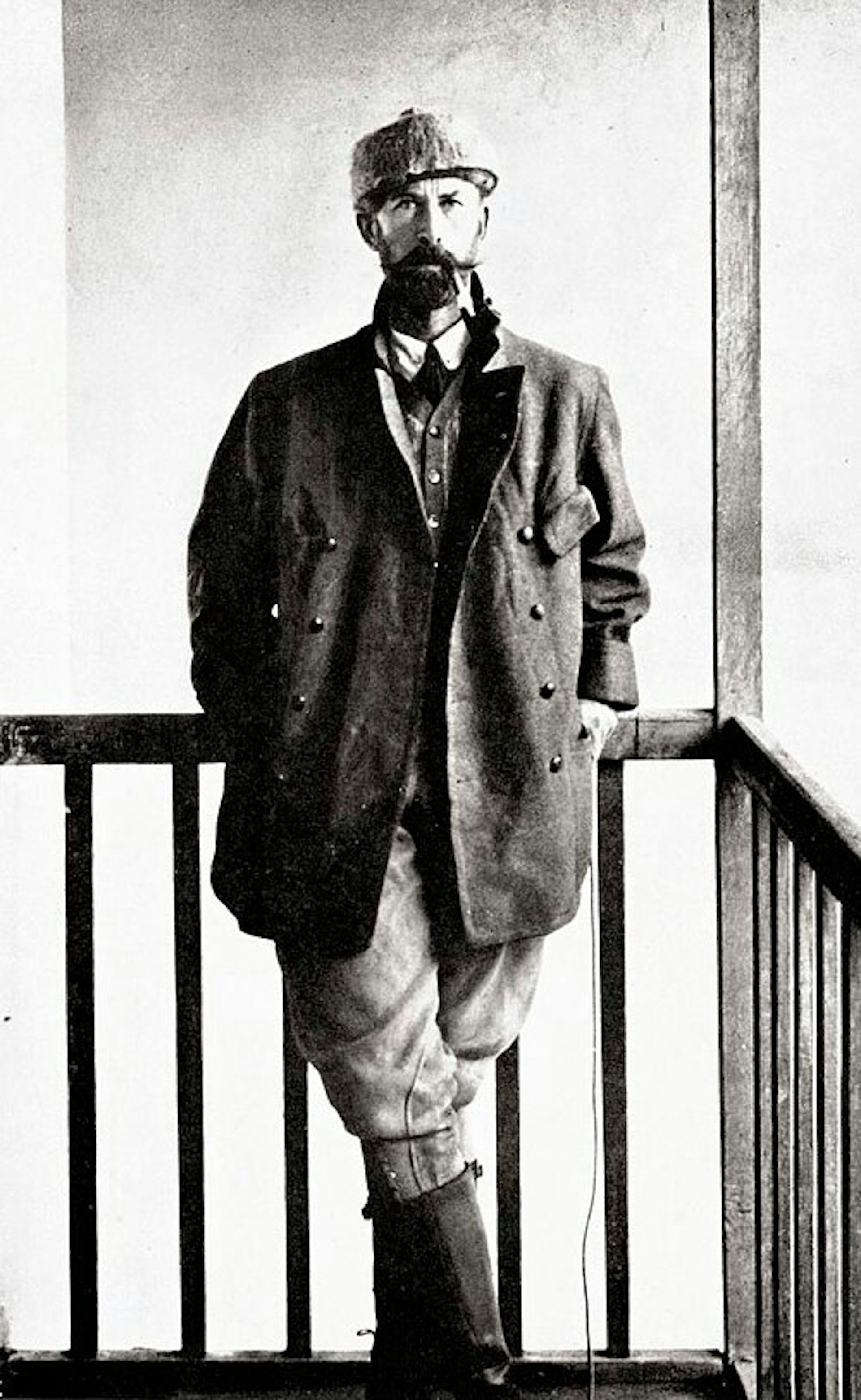
But given all these challenges, it makes the first successful images all the more powerful when they finally appear. The reward is that we’re finally finding the “lost civilisation” that explorers like Percy Fawcett were searching for a century ago, but by cajoling a drone rather than battering through jungle.
ولكن بالنظر إلى كل هذه التحديات، فإن ظهور الصور الناجحة الأولى يجعلها أكثر قوة عندما تظهر أخيراً. المكافأة هي أننا نجد أخيراً “الحضارة المفقودة” التي كان يبحث عنها المستكشفون مثل بيرسي فوسيت قبل قرن من الزمان، ولكن عن طريق إغراء طائرة بدون طيار بدلاً من اقتحام الغابة بعنف.
Incidentally, this technology also has important uses beyond archaeology. It can help people to locate and harvest crops like rubber or açaí palm fruits without having to clear so much rainforest. It is also used by pioneering projects such as Amazonia Revelada, which helps Indigenous and traditional people of the Amazon to prove their historic presence within an area to ward off modern commercial interests like loggers or farmers, while also protecting the living history and nature embedded in these landscapes.
على فكرة، لهذه التكنولوجيا استخدامات مهمة تتجاوز علم الآثار. يمكن أن تساعد الناس في تحديد وحصاد محاصيل مثل المطاط أو ثمار شجرة الأساي دون الحاجة إلى إزالة غابات مطيرة بهذا الحجم. كما أنها تستخدمها المشاريع الرائدة مثل “أمازونيا ريفيلادا” (Amazonia Revelada) ، التي تساعد السكان الأصليين والسكان التقليديين في أمازون على إثبات وجودهم التاريخي داخل منطقة ما لدرء المصالح التجارية الحديثة مثل عمال قطع الأشجار أو المزارعين، مع حماية التاريخ الحي والطبيعة المتأصلة في هذه المناظر الطبيعية.
Other lidar discoveries
اكتشافات ليدار أخرى
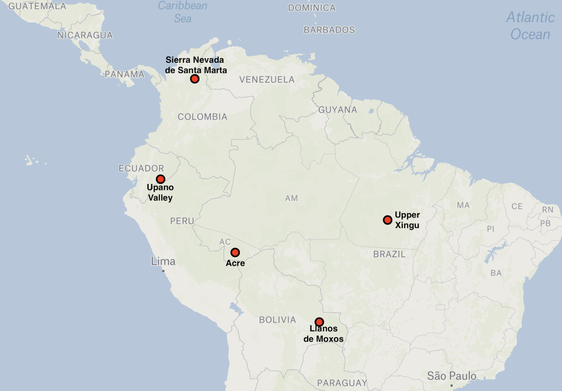
Lidar surveys by French and Ecuadorian archaeologists have revealed that the Llanos de Moxos was certainly not the only example of large-scale, highly integrated society in Amazonia. The Upano Valley, which covers some 300-600km² on the mountainous forest of the Ecuadorian eastern flanks of the Andes, offers another striking example – this time from between about 500BC and AD600–700.
كشفت مسوحات الليدار التي أجراها علماء الآثار الفرنسيون والإكوادوريون أن لانيوس دي موكسوس لم يكن بالتأكيد المثال الوحيد للمجتمع الكبير النطاق والمترابط للغاية في أمازونيا. ويقدم وادي أوبانو، الذي يغطي ما بين 300 و 600 كم² من الغابات الجبلية على المنحدرات الشرقية الإكوادورية لجبال الأنديز، مثالاً لافتاً آخر – هذه المرة يعود إلى الفترة الواقعة بين حوالي 500 قبل الميلاد و 600-700 ميلادية.
Lidar discovery areas
مناطق اكتشاف الليدار
In Upano, archaeologists have been able to map a vast network of settlements connected by extensive road systems, with large platforms and clusters of buildings arranged in organised layouts across a broad area.
في أوبانو، تمكن علماء الآثار من رسم خريطة لشبكة واسعة من المستوطنات المتصلة بأنظمة طرق شاسعة، مع منصات كبيرة وتجمعات مبانٍ مُرتبة في تخطيطات منظمة عبر منطقة واسعة.
What stands out is not just the scale – thousands of structures – but the rigour of the planning. The settlements didn’t just grow randomly, but as part of a deliberate design: we see straight lines of flat-topped platforms laid out in repeating rows and connected by straight paths that cut cleanly across the landscape, as you can see below.
ما يبرز ليس فقط الحجم – آلاف الهياكل – بل دقة التخطيط. لم تنمُ المستوطنات عشوائياً، بل كجزء من تصميم مقصود: نرى خطوطاً مستقيمة من المنصات المسطحة مرتبة في صفوف متكررة ومتصلة بممرات مستقيمة تقطع المشهد الطبيعي بشكل واضح، كما ترون أدناه.
Again, this is not urbanism in the conventional sense of dense, continuous occupation. There would have been none of the vertical stacking of buildings that you’d get in European settlements, and there were also green spaces between platform complexes – much more like a forest city.
مجدداً، هذا ليس تخطيطاً حضرياً بالمعنى التقليدي للإشغال الكثيف والمستمر. لم يكن هناك أي تكديس عمودي للمباني الذي تجده في المستوطنات الأوروبية، وكانت هناك أيضاً مساحات خضراء بين مجمعات المنصات – أشبه بكثير بمدينة الغابة.
Like the Casarabe region, this is a distributed settlement pattern that is both open and highly structured, but the arrangement is much more compact. This reflects the limited flat space available on the upper terraces of the Upano River, which rise up to 100 metres above the surrounding landscape.
مثل منطقة كاسارابي، يمثل هذا النمط الاستيطاني المُوزَّع نمطاً مفتوحاً ومنظماً للغاية، لكن ترتيبه أكثر تكتلاً بكثير. ويعكس ذلك المساحة المسطحة المحدودة المتوفرة على المصاطب العليا لنهر أوبانو، الذي يرتفع حتى 100 متر فوق المشهد الطبيعي المحيط.
Elsewhere in Amazonia, we see more variations. In the Upper Xingu of central Brazil, interconnected settlements were arranged around a shared ceremonial and road network, again suggesting a regionally coordinated social world.
في أماكن أخرى في الأمازونيا، نرى المزيد من التنوعات. ففي منطقة إكسينغو العليا بوسط البرازيل، كانت المستوطنات المترابطة مرتبة حول شبكة احتفالية وطرق مشتركة، مما يشير مجدداً إلى عالم اجتماعي منسق على المستوى الإقليمي.
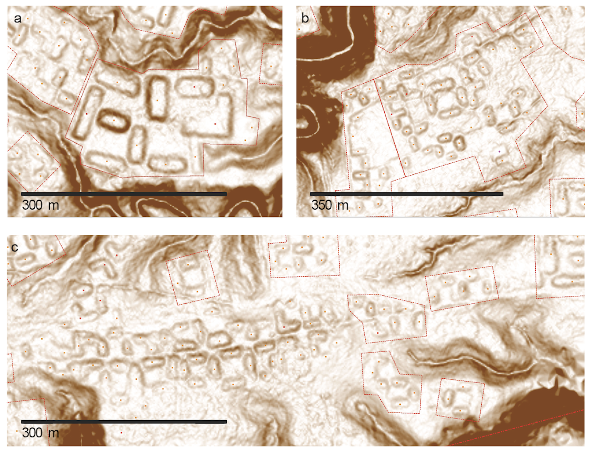
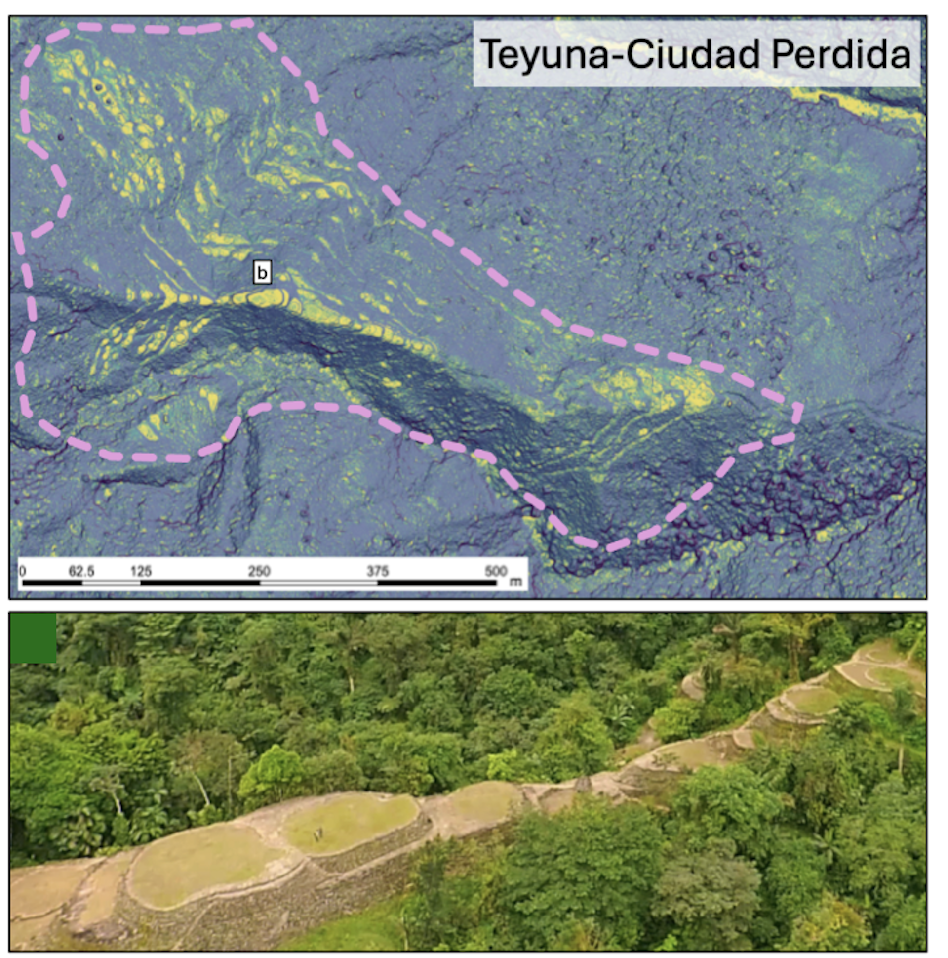
Further north, the Tairona people of the Sierra Nevada de Santa Marta in present-day Colombia built terraced stone towns in the mountains, linked by paved paths. This was a form of urbanism shaped entirely by the demands of steep, high-altitude terrain. Below is a lidar image of one area in this region, with the platforms that would have housed the settlements marked in yellow. Below that, you can see what the platforms look like.
شمالاً، بنى شعب التايرونا في سييرا نيفادا دي سانتا مارتا في كولومبيا الحالية مدنًا حجرية متدرجة في الجبال، مرتبطة بممرات مرصوفة. كان هذا شكلاً من أشكال التخطيط الحضري تشكّل بالكامل بفعل متطلبات التضاريس الوعرة والمرتفعة. أدناه توجد صورة ليدار لمنطقة واحدة في هذه المنطقة، مع تحديد المنصات التي كانت ستضم المستوطنات باللون الأصفر. وأسفل ذلك، يمكنك رؤية كيف تبدو هذه المنصات.
In western Amazonia, Acre adds another important variation. From around AD1–1000, people built large ditched enclosures, or geoglyphs, mainly in the south-eastern part of this region along the upper Purus River. These were square, circular, hexagonal or octagonal mounds, often 1-3 hectares in size, with ditches up to four metres deep. These were probably used as ceremonial gathering places rather than permanent settlements.
في غرب أمازونيا، تضيف منطقة أكري تنوعاً مهماً آخر. فمن حوالي عام 1 إلى 1000 ميلادية، بنى الناس تحصينات كبيرة محفورة أو رسومات أرضية (جيوجليف) ، تتركز بشكل رئيسي في الجزء الجنوبي الشرقي من هذه المنطقة على طول نهر بوروس العلوي. كانت هذه التكوينات عبارة عن تلال مربعة أو دائرية أو سداسية أو ثمانية الأضلاع، يبلغ حجمها غالباً ما بين 1 إلى 3 هكتارات، وتحتوي على خنادق يصل عمقها إلى أربعة أمتار. ومن المحتمل أن تكون قد استُخدمت كمواقع لتجمعات احتفالية بدلاً من كونها مستوطنات دائمة.
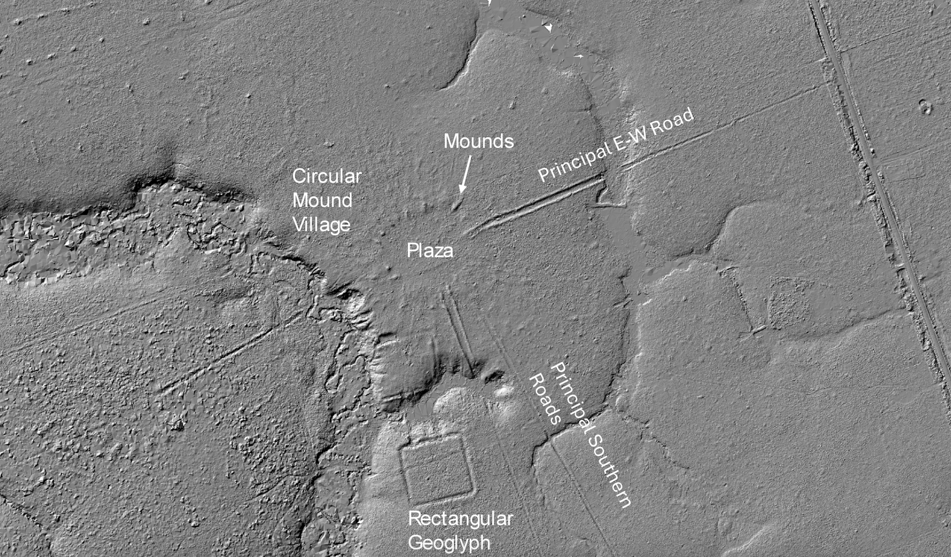
After about AD1000, these were followed by what we call circular mound villages, occupied until around AD 1650–1700. They featured rings of mounds around central plazas and straight roads radiating out like the rays of the Sun, often built to align with the four main compass points. These “Sun villages” were true settlements, and formed interconnected networks across the southern rim of Amazonia. You can see an example in the lidar image below.
بعد حوالي عام 1000 ميلادية، تبعتها ما نسميه القرى التلالية الدائرية، التي سُكِنَت حتى حوالي عام 1650–1700 ميلادية. كانت تتميز بحلقات من التلال حول ساحات مركزية وطرق مستقيمة تشع كأشعة الشمس، وغالباً ما بُنيت لتتماشى مع النقاط الأربع الرئيسية للبوصلة. كانت هذه “قرى الشمس” مستوطنات حقيقية، وشكلت شبكات مترابطة عبر الحافة الجنوبية لأمازونيا. يمكنكم رؤية مثال في صورة الليدار أدناه.
Taken together, these discoveries fundamentally reshape our understanding of Amazonia. We now see a mosaic of managed landscapes, engineered environments and, in some cases, city-scale societies. What unites them is not a shared blueprint but a shared impulse: the organisation of people, space and movement across large landscapes in ways that were deliberate, durable and distinctly their own.
مجتمعة، تعيد هذه الاكتشافات تشكيل فهمنا للأمازونيا بشكل جوهري. نرى الآن فسيفساء من المناظر الطبيعية المُدارة، والبيئات المصممة هندسيًا، وفي بعض الحالات، مجتمعات بحجم المدن. ما يوحدها ليس مخططاً مشتركاً، بل دافعاً مشتركاً: وهو تنظيم الناس والمكان والحركة عبر المناظر الطبيعية الواسعة بطرق كانت متعمدة ومستدامة ومميزة بها وحدها.
To stress, Amazonia was not uniformly dense or urban. It supported a diversity of types of settlements, from dispersed networks like Moxos to tighter grids like Upano, each of them adapted to local ecological conditions. They shared a low-density urbanism, in the sense of large, interconnected populations without the density of classic cities.
من المهم التأكيد على أن أمازونيا لم تكن كثيفة أو حضرية بشكل موحد. بل دعمت تنوعاً من أنواع المستوطنات، بدءاً من الشبكات المبعثرة مثل موكسوس وصولاً إلى الشبكات الأكثر كثافة مثل أوبانو، وقد تكيفت كل منها مع الظروف البيئية المحلية. لقد تشاركت نمطاً حضرياً منخفض الكثافة، بمعنى وجود تجمعات سكانية كبيرة ومترابطة دون كثافة المدن الكلاسيكية.
What we still don’t know
ما زلنا لا نعرف
How were these societies organised politically and socially? How did they interact with variations in the climate and environment, ranging from the heavy rainfalls and droughts caused by El Niño to rivers forging new routes that could move them away from a settlement within a few generations?
كيف كانت هذه المجتمعات منظمة سياسياً واجتماعياً؟ وكيف تفاعلت مع التباينات المناخية والبيئية، بدءاً من الأمطار الغزيرة والجفاف الناجم عن ظاهرة النينيو وصولاً إلى الأنهار التي شقت مسارات جديدة قد تنقلها بعيداً عن مستوطنة ما في غضون أجيال قليلة؟
What, if any, connections existed with mountain societies in the Andes? And perhaps most importantly, since both the Casarabe and Upano ceased to build monuments after 1492, what led to their transformation or decline before the arrival of Europeans?
ما هي الروابط، إن وجدت، مع مجتمعات الجبال في جبال الأنديز؟ والأهم من ذلك ربما، بما أن كلًا من الكاسارابي والأوبانو توقفا عن بناء الآثار بعد عام 1492، فما الذي أدى إلى تحولهما أو تدهورهما قبل وصول الأوروبيين؟
There is active debate between archaeologists over whether these societies transformed because of environmental stress, internal political change, or shifts in things like trade routes or migration.
هناك نقاش نشط بين علماء الآثار حول ما إذا كانت هذه المجتمعات قد تحولت بسبب الضغط البيئي، أم التغير السياسي الداخلي، أو التحولات في أشياء مثل طرق التجارة أو الهجرة.
In the Llanos de Moxos, one possibility is that a prolonged period of climate change affected the Casarabe water-management systems that were so critical to feeding this thriving society. In the Upano Valley, volcanic eruptions and earthquakes may have disrupted settlements and agriculture, although it’s unclear whether that could have led to the area being abandoned.
في لانيوس دي موكسوس (Llanos de Moxos) ، إحدى الاحتمالات هي أن فترة مطولة من تغير المناخ أثرت على أنظمة إدارة المياه لدى الكاسارابي، وهي الأنظمة التي كانت حيوية للغاية لإطعام هذا المجتمع المزدهر. وفي وادي الأوبانو، ربما تسببت الثورات البركانية والزلازل في تعطيل المستوطنات والزراعة، على الرغم من أنه من غير الواضح ما إذا كان ذلك قد أدى إلى هجر المنطقة.
It seems likely that as we uncover new things, it will reveal more and more integration between different societies. What we are seeing now in Amazonia is much like looking at a satellite image of a country at night: bright, isolated clusters of light – cities that appear disconnected. But as we continue to expand our coverage and fill in the gaps, I think this will change.
يبدو مرجحاً أنه كلما كشفنا عن أشياء جديدة، سيكشف ذلك المزيد والمزيد من التكامل بين المجتمعات المختلفة. ما نراه الآن في أمازونيا يشبه كثيراً النظر إلى صورة فضائية لبلد ليلاً: تجمعات ضوئية ساطعة ومعزولة – مدن تبدو غير متصلة. ولكن مع استمرارنا في توسيع نطاق تغطيتنا وسد الفجوات، أعتقد أن هذا سيتغير.
What now appear as isolated clusters may also resolve into extensive networks. For example a study across the southern rim of Amazonia has predicted that the kinds of settlement mounds that have been identified so far are likely to occur across about 400,000km², supporting an estimated regional population of roughly 500,000 to 1 million people in the era before the Europeans arrived.
ما يبدو الآن كتجمعات معزولة قد يتكشف أيضاً ليصبح شبكات واسعة النطاق. على سبيل المثال، توقعت دراسة أجريت عبر الحافة الجنوبية لأمازونيا أن أنواع التلال الاستيطانية التي تم تحديدها حتى الآن من المحتمل أن توجد عبر مساحة تبلغ حوالي 400,000 كيلومتر مربع، مما يدعم تقديرات بوجود عدد سكاني إقليمي يتراوح بين 500,000 و مليون شخص في الحقبة التي سبقت وصول الأوروبيين.
Entire regions may emerge as previously unrecognised centres of population and landscape management. This could be particularly so for the Llanos de Moxos. The whole area covers as much as 200,000km², depending on where you draw the boundaries, stretching into Brazil and even Peru. It is often divided into several apparently distinct cultural regions — the Casarabe (aka the monumental mound region) , and then two others called the platform ridge and zanjas (ditches) regions.
قد تظهر مناطق بأكملها كمركز سكن وإدارة للمناظر الطبيعية لم يكن معروفاً من قبل. وقد يكون هذا صحيحًا بشكل خاص بالنسبة لـ “لانيوس دي موكسوس.” تغطي المنطقة بأكملها ما يصل إلى 200,000 كيلومتر مربع، اعتماداً على مكان رسم الحدود، وتمتد لتشمل البرازيل وحتى بيرو. وغالباً ما تنقسم إلى عدة مناطق ثقافية تبدو متميزة- منطقة الكاسارابي (المعروفة بمنطقة التلال الأثرية الضخمة) ، ومن ثم منطقتين أخريين تسمى كل منهما “حافة المنصة” ومناطق “الخنادق.”
As lidar coverage expands and more archaeological work is conducted, we may begin to understand how these societies were economically specialised. We know, for example, that the fortified villages of the zanjas region had fish weirs spanning hundreds of miles that were capable of capturing vast quantities of migratory fish. The platform ridge region consisted of large drained fields, which could potentially produce surpluses of maize. It is conceivable that these belonged to a broader network that supported the more complex Casarabe centres.
مع توسع تغطية نظام ليدار (lidar) وإجراء المزيد من الأعمال الأثرية، قد نبدأ في فهم كيف كانت هذه المجتمعات متخصصة اقتصادياً. نحن نعلم، على سبيل المثال، أن القرى المحصنة في منطقة الخنادق كان بها مصائد سمكية تمتد لمئات الأميال وكانت قادرة على اصطياد كميات هائلة من الأسماك المهاجرة. أما منطقة حافة المنصة فكانت تتكون من حقول كبيرة ومجففة، والتي يمكن أن تنتج فائضاً محتملاً من الذرة. ومن المعقول افتراض أن هذه الأجزاء كانت تنتمي إلى شبكة أوسع دعمت مراكز الكاسارابي الأكثر تعقيداً.
Or perhaps – who knows – the relationships were more fluid and reciprocal. For now, the question remains open. But it is precisely this possibility of deep regional integration that lidar is beginning to bring into view. In time, we may even begin to identify Casarabe outposts scattered across the Llanos de Moxos.
أو ربما – من يدري – كانت العلاقات أكثر سيولة وتفاعلية. في الوقت الحالي، يظل السؤال مفتوحاً. ولكن تحديداً هذا الاحتمال للتكامل الإقليمي العميق هو ما بدأ نظام ليدار بالكشف عنه. مع مرور الوقت، قد نبدأ حتى في تحديد نقاط تواجُد الكاسارابي المتناثرة عبر “لانيوس دي موكسوس.”
What happens next
ماذا سيحدث بعد ذلك
There’s still a huge amount to be done with lidar. Vast areas, particularly in the Ecuadorian and Peruvian Amazon – remain unexplored. One recent study suggested that there could be more than 10,000 more urban structures of the kind I’ve been describing still hidden throughout Amazonia, all of them dating from pre-European times.
لا يزال هناك قدر كبير من العمل الواجب إنجازه باستخدام تقنية الليدار. مناطق شاسعة، ولا سيما في أمازون الإكوادور وبيرو، لا تزال غير مكتشفة. أشارت دراسة حديثة إلى أنه قد يكون هناك أكثر من 10,000 هيكل حضري إضافي من النوع الذي كنت أصفه، لا يزال مخبأً في جميع أنحاء الأمازونيا، وكلها تعود إلى عصور ما قبل الأوروبيين.
Looking ahead 20 years, it is likely that our map of Amazonia will look very different. One promising technology is satellite-based lidar systems, which could provide broader, though less detailed, datasets across large areas. Advances in machine learning are also beginning to help us identify archaeological features within massive datasets, speeding up a labour-intensive process.
بالنظر إلى العشرين عامًا القادمة، من المرجح أن تبدو خريطتنا لأمازونيا مختلفة تماماً. إحدى التقنيات الواعدة هي أنظمة ليدار المعتمدة على الأقمار الصناعية، والتي يمكنها توفير مجموعات بيانات أوسع نطاقاً، وإن كانت أقل تفصيلاً، عبر مساحات شاسعة. كما بدأت التطورات في التعلم الآلي بمساعدتنا على تحديد الميزات الأثرية ضمن مجموعات بيانات ضخمة، مما يسرّع عملية كانت تتطلب الكثير من الجهد اليدوي.
Against this, there are time pressures in some places. Llanos de Moxos, for instance, is unfortunately in rapid transition. The very ground that holds the traces of ancient networks is being transformed by mechanised agriculture and large-scale terraforming for rice cultivation and pastures.
على النقيض من ذلك، هناك ضغوط زمنية في بعض الأماكن. فـ “ليانوس دي موكسوس”، على سبيل المثال، يمر للأسف بتحول سريع. إن الأرض ذاتها التي تحمل آثار الشبكات القديمة تتعرض للتحول بفعل الزراعة الميكانيكية والتكوين الأرضي واسع النطاق لزراعة الأرز والمراعي.
We also need to keep reminding ourselves that lidar is only the first step. What really matters is how it’s brought together with other lines of evidence. Most sites discovered by lidar have yet to be excavated, so we’ll have to do much of that, looking for everything from bones and plants to ceramics and weapons.
يجب علينا أيضاً أن نذكر أنفسنا بأن الليدار هو مجرد الخطوة الأولى. ما يهم حقاً هو كيف يتم دمجه مع خطوط أدلة أخرى. لم تتم حفر معظم المواقع المكتشفة بواسطة الليدار بعد، لذلك سيتعين علينا القيام بالكثير من ذلك، بحثاً عن كل شيء بدءاً من العظام والنباتات وصولاً إلى السيراميك والأسلحة.
So far, most excavation has been in the Casarabe area of the Llanos de Moxos. The reason, for instance, that we know the culture lived primarily on maize was through the discovery of over 60 human skeletons, which underwent carbon isotope analysis. The same research paper also analysed excavated duck bones to show that the Casarabe were feeding them maize too, suggesting animal domestication in a continent that was not generally known for it.
حتى الآن، تركز معظم أعمال التنقيب في منطقة الكاسارابي ضمن سهول موكسوس (Llanos de Moxos) . والسبب الذي جعلنا نعرف، على سبيل المثال، أن هذه الثقافة عاشت بشكل أساسي على الذرة كان من خلال اكتشاف أكثر من 60 هيكلاً عظمياً بشرياً خضع لتحليل النظائر الكربونية. كما قام نفس البحث بتحليل عظام البط المنقوبة لإثبات أن الكاسارابي كانوا يطعمونها الذرة أيضاً، مما يشير إلى تدجين الحيوانات في قارة لم تكن معروفة عموماً بذلك.
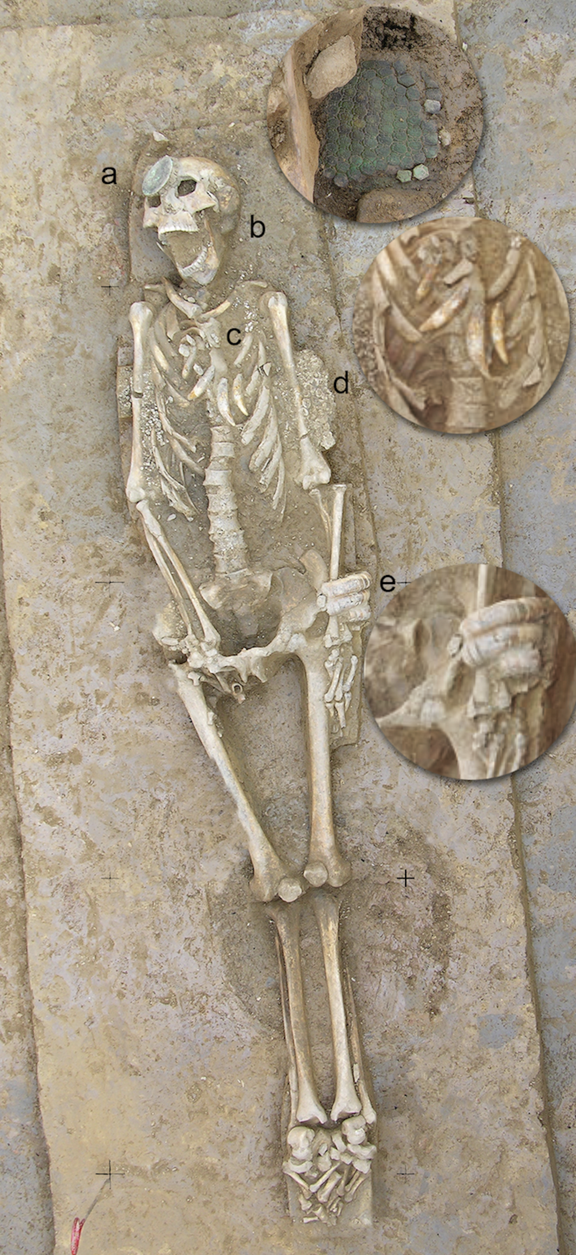
Another fascinating Casarabe find is a single buried skeleton who may have been a leader, because he had a collar of jaguar teeth around his neck. He was also wearing ear pieces made of armadillo shell, studded with mottled blue stones called sodalite – it’s not clear what these were for.
اكتشاف ساحر آخر في كاسارابي هو هيكل عظمي مدفون واحد، قد يكون قائدًا، لأنه كان يرتدي طوقاً من أسنان اليغوار حول عنقه. كما كان يرتدي قطع أذن مصنوعة من قشرة الأرماديلو، مرصعة بأحجار زرقاء متبقعة تسمى السدالايت – وليس من الواضح الغرض منها.
We’ll also need to obtain more precise dates for key events using techniques like radiocarbon dating, and more pinpoint accurate environmental data to help support theories about ancient changes to the climate – as opposed to the wider regional information we’ve tended to rely on until now. Lake sediments are great environmental archives, preserving evidence of things like vegetation change and landscape disturbance.
سنحتاج أيضًا إلى الحصول على تواريخ أكثر دقة للأحداث الرئيسية باستخدام تقنيات مثل التأريخ بالكربون المشع، وبيانات بيئية دقيقة ومحددة لمساعدة دعم النظريات المتعلقة بالتغيرات المناخية القديمة – بدلاً من المعلومات الإقليمية الأوسع التي اعتدنا الاعتماد عليها حتى الآن. تُعد رواسب البحيرات أرشيفات بيئية ممتازة، حيث تحافظ على أدلة أشياء مثل تغير الغطاء النباتي واضطراب المشهد الطبيعي.
Also important is comparing genetic data from excavated bones with people who live in these areas today – in dialogue and collaboration with local communities whose histories, memories and knowledge are essential to understanding these landscapes.
ومن المهم أيضاً مقارنة البيانات الوراثية المستخلصة من العظام المحفورة بالأشخاص الذين يعيشون في هذه المناطق اليوم، وذلك في حوار وتعاون مع المجتمعات المحلية التي تُعدّ تاريخها وذكرياتها ومعارفها ضرورية لفهم هذه المناظر الطبيعية.
It’s all a question of how lidar is brought together with all this other evidence. The most convincing reconstructions will come from the convergence of all of these. One further major challenge ahead, however, will be to bridge the gap between scientific reconstructions and how past peoples understood and inhabited their world. Archaeology is increasingly rich in data, but we have to relate it to lived experience.
إن الأمر كله مسألة تتعلق بكيفية دمج بيانات الليدار مع كل هذه الأدلة الأخرى. وستأتي أكثر عمليات إعادة البناء إقناعاً من تقارب جميع هذه العناصر. ومع ذلك، سيكون هناك تحدٍ رئيسي آخر يواجهنا وهو سد الفجوة بين عمليات إعادة البناء العلمية وكيف فهم الشعوب الماضية لعالمها وسكنته. فبالرغم من أن علم الآثار أصبح غنياً بالبيانات بشكل متزايد، إلا أنه يتوجب علينا ربط هذه البيانات بالتجارب المعيشة.
That is no easy feat, but it is essential if we are to move from mapping past worlds to understanding them. Crucially, Amazonia – with its rich, still-vibrant Indigenous societies and ethnographic record – offers an exceptional opportunity to do this, providing rare continuities through which to anchor and critically engage our interpretations of the past.
إن هذا ليس إنجازاً سهلاً، ولكنه ضروري إذا أردنا الانتقال من مجرد رسم خرائط للعوالم الماضية إلى فهمها حقاً. والأهم من ذلك، أن منطقة أمازونيا – بمجتمعاتها الأصلية الغنية واللا تزال نابضة بالحياة وسجلها الإثنوغرافي – تقدم فرصة استثنائية لتحقيق ذلك، حيث توفر استمراريات نادرة يمكن من خلالها تأصيل وتفاعل نقدي مع تفسيراتنا للماضي.
Lessons for today
دروس لليوم
My own sense is that we will move towards a view of Amazonia not as an exception, in line with the old view that the people lived within an untouched paradise, but as part of a broader pattern of human-environment interaction. The rainforest will be understood not only as a biological system, but as a historical one – shaped, in part, by the people who lived within it.
إن شعوري الشخصي هو أننا سنتجه نحو رؤية لأمازونيا لا باعتبارها استثناءً، على غرار الرؤية القديمة التي تفترض أن الناس عاشوا داخل جنة لم تمسسها يد، بل كجزء من نمط أوسع للتفاعل بين الإنسان والبيئة. وسيُفهم الغابات المطيرة ليس فقط كنظام بيولوجي، بل كنظام تاريخي أيضاً – تشكّل جزئياً بفعل الأشخاص الذين عاشوا فيها.
This does not mean the Amazonian people who simply lived “in harmony” with nature; the evidence points to something more interesting. Although Amazonian societies developed complex, and at times intensive, forms of land use, the evidence consistently shows that they often did so while maintaining continuous forest cover. Far from the large-scale deforestation that we might assume was necessary for such elaborate forms of human life, their practices created mosaics of managed forest, gardens, orchards, wetlands and settlement areas.
هذا لا يعني أن سكان الأمازون عاشوا ببساطة “في وئام” مع الطبيعة؛ فالأدلة تشير إلى شيء أكثر إثارة للاهتمام. فعلى الرغم من أن المجتمعات الأمازونية طورت أشكالاً معقدة، وفي بعض الأحيان مكثفة، لاستخدام الأراضي، فإن الأدلة تُظهر باستمرار أنها غالباً ما فعلت ذلك مع الحفاظ على غطاء غابي مستمر. وبعيداً عن إزالة الغابات واسعة النطاق التي قد نفترض أنها ضرورية لمثل هذه الأشكال المعقدة من الحياة البشرية، فقد خلقت ممارساتهم فسيفساء من الغابات المُدارة والحدائق والبساتين والأراضي الرطبة ومناطق الاستيطان.
We know partly from lake sediment data that people enriched the forests with species that provided food, building materials, medicines and other resources, from açaí and cacao to palms, cinchona and copaiba. The fact that some of these species endure today suggests that past land use left lasting ecological legacies.
نحن نعرف جزئياً، بناءً على بيانات رواسب البحيرات، أن الناس أثروا الغابات بأنواع نباتية وفرت الغذاء والمواد الإنشائية والأدوية وغيرها من الموارد، بدءاً من الأساي والكاكاو وصولاً إلى أشجار النخيل والسِنكونا والكوبايبا. وحقيقة أن بعض هذه الأنواع لا تزال باقية حتى اليوم تشير إلى أن استخدام الأراضي في الماضي ترك إرثاً بيئياً دائماً.
In the context of today’s climate crisis, the long-term balance that these people achieved offers a powerful lesson: it is possible to sustain complex societies without destroying the forest, if land use is guided by principles that integrate ecological knowledge, cultural values and a commitment to the continuity of the living landscape.
في سياق أزمة المناخ الحالية، يقدم التوازن طويل الأمد الذي حققه هؤلاء الناس درساً قوياً: فمن الممكن دعم مجتمعات معقدة دون تدمير الغابة، إذا تم توجيه استخدام الأراضي بمبادئ تدمج المعرفة البيئية والقيم الثقافية والالتزام باستمرارية المشهد الحي.
What lies beneath the Amazon is not just a hidden past. It is a reminder that even the most seemingly untouched landscapes can carry deep histories, waiting – sometimes just beneath our feet – to be revealed.
ما يكمن تحت الأمازون ليس مجرد ماضٍ خفي. إنه تذكير بأن حتى أكثر المناظر الطبيعية التي تبدو غير ممسوسة يمكن أن تحمل تاريخاً عميقاً، ينتظر – أحياناً تحت أقدامنا مباشرة – ليُكشف عنه.
This article features references to books that have been included for editorial reasons, and may contain links to bookshop.org. If you click on one of the links and go on to buy something from bookshop.org The Conversation UK may earn a commission.
يحتوي هذا المقال على إشارات إلى كتب تم تضمينها لأسباب تحريرية، وقد يحتوي على روابط لموقع bookshop.org. إذا نقرت على أحد الروابط وذهبت لشراء شيء من bookshop.org فقد يكتسب موقع The Conversation UK عمولة.
For you: more from our Insights series:
لك: المزيد من سلسلتنا “رؤى”:
Underground data fortresses: the nuclear bunkers, mines and mountains being transformed to protect our ‘new gold’ from attack
حصون البيانات تحت الأرض: الملاجئ النووية والمناجم والجبال التي يتم تحويلها لحماية “ذهبنا الجديد” من الهجوم
‘People think you come out … and live happily ever after. If only.’ The reality of life after wrongful conviction
“يعتقد الناس أنك ستخرج… وتعيش بسعادة إلى الأبد. يا ليت.” واقع الحياة بعد الإدانة الخاطئة
The grief myth: it doesn’t come in stages or follow a checklist – like love, it endures
أسطورة الحزن: لا تأتي على مراحل أو تتبع قائمة مراجعة – مثل الحب، إنها تدوم
Inside Porton Down: what I learned during three years at the UK’s most secretive chemical weapons laboratory
داخل بورتون داون: ما تعلمته خلال ثلاث سنوات في أكثر مختبر أسلحة كيميائية سرية في المملكة المتحدة
To hear about new Insights articles, join the hundreds of thousands of people who value The Conversation’s evidence-based news. Subscribe to our newsletter.
لمعرفة المزيد عن مقالات “رؤى” الجديدة، انضم إلى المئات الآلاف من الأشخاص الذين يقدرون الأخبار القائمة على الأدلة التي يقدمها موقع The Conversation. اشترك في نشرتنا الإخبارية.
José Iriarte receives funding from the European Research Council, the Arts and Humanities Research Council, the British Academy, National Geographic and the Wenner-Gren Foundation for Anthropological Research.
يتلقى خوسيه إريارته تمويلاً من المجلس الأوروبي للبحوث، والمجلس البحثي للفنون والعلوم الإنسانية، والأكاديمية البريطانية، والمكتبة الوطنية للجغرافيا، ومؤسسة وينر-غرين للأبحاث الأنثروبولوجية.
Read more
-

في نظام عالمي متصدع، أين يقع الجنوب العالمي؟
In a fractured world order, where does the global south fit in?
-

لقد حللنا 14 مليون منشور على ريديت للكشف عن تحول لافت في طريقة حديثنا عن الصحة العقلية
We analysed 14 million Reddit posts to reveal a striking shift in how we talk about mental health