
地图是塑造一个国家过去、现在和未来的强大政治工具——反地图让普通人能够夺回叙事权。
Maps are powerful political tools shaping a nation’s pa…
From who gets to vote to how people travel and where taxpayer dollars are funneled, politicians and urban planners wield maps to control public imagination.
从谁有投票权,到人们如何出行,再到纳税人的资金流向何方,政客和城市规划者都利用地图来控制公众的想象力。
Throughout time, maps have been useful tools for those in power to stake their claim over territories and markets. Politicians start nationwide redistricting battles to ensure partisan control, weakening the power of voters. The Trump administration’s geopolitical posturing over Greenland builds on a long history of imperialism aided by maps. And in ancient Rome, the Peutinger map depicted vast ideas of empire by placing Rome at the center of the world.
纵观历史,地图一直是掌权者用来宣示其对领土和市场主权的有用工具。政客们会发起全国性的重新划分选区战,以确保党派控制,削弱选民的力量。特朗普政府对格陵兰的地缘政治姿态,建立在一段长期受地图辅助的帝国主义历史之上。而在古罗马时期,佩廷格地图通过将罗马置于世界中心,描绘了宏大的帝国理念。
But maps can also tell hidden stories about politics and power that help people reclaim access to their own spaces and futures. These include counter maps – that is, maps that rework existing assumptions – to expand on the dominant narratives about a place to include viewpoints that were previously excluded.
但地图也可以讲述关于政治和权力的隐藏故事,帮助人们重新夺回对自己空间和未来的掌控。这些包括“反地图”——即重构现有假设的地图——它们旨在扩展关于某个地方的主流叙事,纳入那些先前被排除的观点。
As an urban and architectural designer, mapper and spatial politics researcher, I’ve seen how maps shape urban spaces and the stories told about them. I’ve also seen how maps have the power to question these stories, opening up other meanings a place can have that are shared by everyday residents and workers.
作为一名城市和建筑设计师、制图师和空间政治研究员,我亲眼目睹了地图如何塑造城市空间以及人们讲述的故事。我也看到地图具有质疑这些故事的力量,开启了普通居民和工人所共享的、一个地方可能拥有的其他意义。
More than just digital wayfinding aids, maps are strategic tools of world-building. Maps show how certain ideas and boundaries that people may think are fixed can be rendered flexible. Anyone can make a map, and because maps are instruments of spatial storytelling, the possibilities they reveal about places are actually endless.
地图不仅仅是数字导航辅助工具,它们更是构建世界的战略工具。地图展示了人们可能认为固定不变的某些观念和边界是如何被描绘得灵活的。任何人都可以制作地图,由于地图是空间叙事的工具,它们揭示出的关于地方的可能性实际上是无穷无尽的。
Who makes the maps?
谁制作地图?
Geographer Mark Monmonier famously described how to lie with maps. He pointed out that mapmakers who have power, like governments and companies, use selective editing to advance specific goals or disseminate a brand.
地理学家马克·蒙莫尼尔(Mark Monmonier)曾著名地描述了如何用地图撒谎。他指出,拥有权力的制图师,例如政府和公司,会使用选择性编辑来推进特定的目标或传播某个品牌。
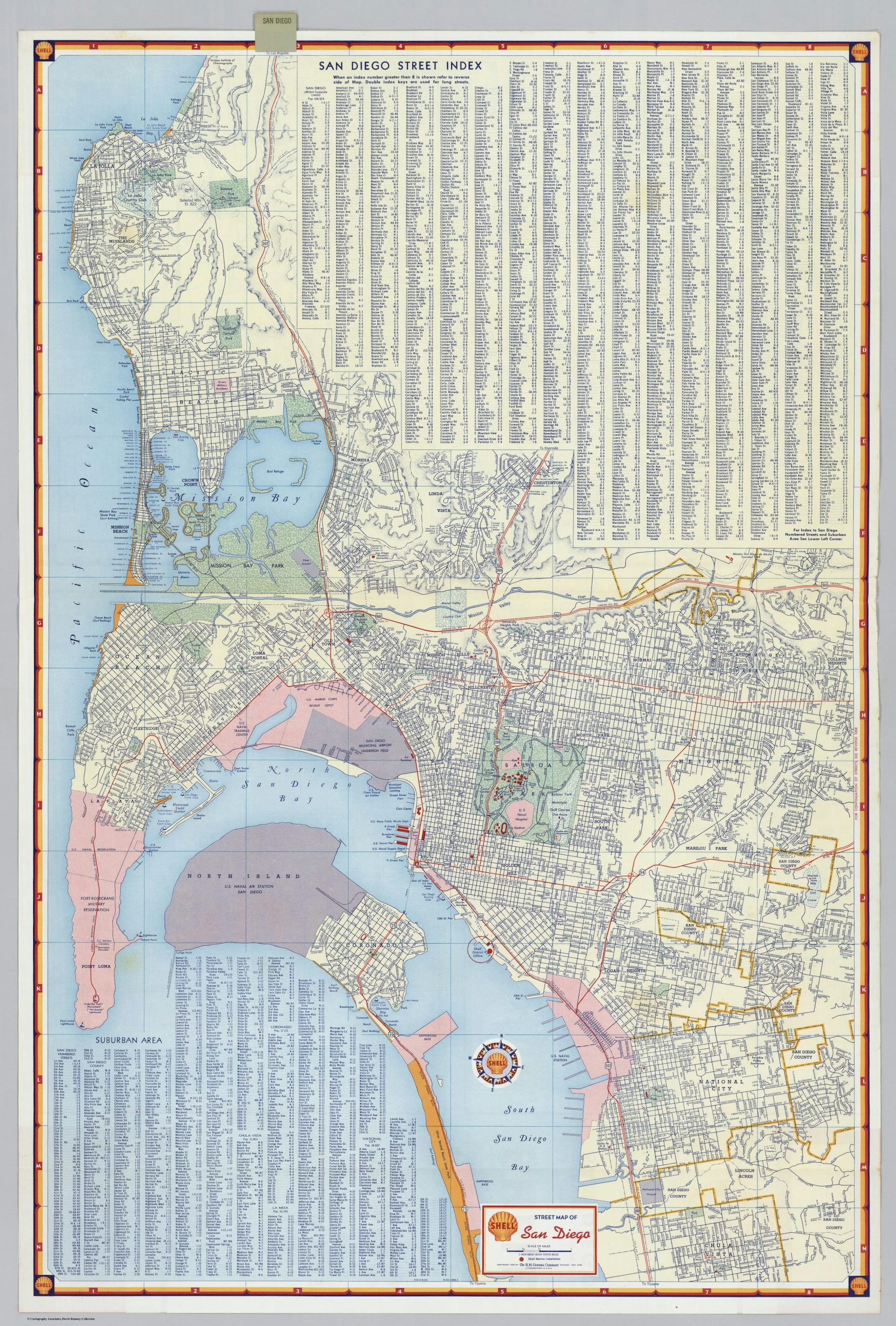
The Shell Oil road maps of the 1950s are a useful example of maps as marketing. With a large logo on the front and the Shell north star compass on the inside, these maps were provided free in gas stations across the country. They advertised the brand while facilitating auto travel by delineating roads and major features, including mileage charts on the backs so motorists could plan gas stops. The maps omitted competing transit systems like bus routes.
20世纪50年代的壳牌(Shell Oil)公路地图是地图作为营销的一个有益的例子。这些地图的正面印有大型标志,内部印有壳牌北极星指南,并在全国各地的加油站免费提供。它们通过描绘道路和主要特征来宣传品牌,同时又方便了汽车旅行,地图背面甚至还有里程表,让驾车者可以规划加油点。这些地图省略了公交路线等竞争性的交通系统。
Public agencies and public-private partnerships also advance agendas via maps. The Home Ownership Loan Corporation redlined maps of the 1930s show even more directly how the government and real estate industry used maps to exclude certain communities. These maps were made for almost every major American city, and the zones they marked as risky for lenders coincided with neighborhoods where African Americans lived, thus taking them out of the home ownership market.
公共机构和公私合作关系也通过地图推进议程。20世纪30年代住房贷款公司(Home Ownership Loan Corporation)的红线地图更直接地展示了政府和房地产行业如何利用地图排除某些社区。这些地图几乎为美国每个主要城市制作,而它们标记为贷款人风险区域的区域,恰好与非裔美国人居住的社区重合,从而将他们排除在购房市场之外。
One can look today to gerrymandering efforts in states like Texas and Florida to see how maps are used to control who has access to the levers of democracy. These redistricting cases were done outside of a typical census year in order to win more congressional seats in the 2026 elections.
今天,我们可以看看德克萨斯州和佛罗里达州等州的划分选区(gerrymandering)努力,了解地图是如何被用来控制谁能接触到民主的权力杠杆的。这些重新划分选区的案例是在典型的普查年份之外进行的,目的是为了赢得2026年选举中更多的国会席位。
Remapping the ‘behind the scenes’
重新映射“幕后”
If maps are used to systematically shut minority neighborhoods out of property markets, then remapping these systems can reveal how the strings of government and private industry are pulled to exclude these neighborhoods, and whom this exclusion benefits.
如果地图被用于系统性地将少数族裔社区排除在房地产市场之外,那么重新绘制这些系统可以揭示政府和私营产业是如何操纵排除这些社区的,以及谁从这种排除中获益。
In my book “Radical Atlas of Ferguson, USA,” I remap this American city to show what happens behind the scenes in regional and municipal planning, revealing why such stark conditions of inequality persist there.
在我的著作《美国费格森激进地图集》中,我重新绘制了这座美国城市,以展示区域和市政规划背后的运作机制,揭示了当地不平等状况为何如此顽固地持续存在。
The suburb of Ferguson, in North St. Louis County, Missouri, made it into the national spotlight in 2014 after a white police officer shot and killed Michael Brown Jr., an unarmed Black teenager. The community response to this injustice helped to spur the Black Lives Matter movement.
位于密苏里州北圣路易斯县的费格森郊区,在2014年发生一起白人警察射杀未携带武器的黑人青少年迈克尔·布朗(Michael Brown Jr.)的事件后,引起了全国的关注。 社区对这种不公的反应,有助于推动了“黑人生命至上”(Black Lives Matter)运动。
With the maps in this book, I layered in new stories to unpack the strained political and economic context underlying Ferguson. For example, historian Walter Johnson points out that there are several major Fortune 500 companies located just blocks from where Brown was killed. While those companies receive heavy tax subsidies and public development incentives for their physical growth, the rest of the municipality’s spending for necessities like public schools and sidewalks remains underfunded. By highlighting these facets of the landscape, maps can show who actually controls the imaginations of urban planners and politicians.
通过本书中的地图,我叠加了新的叙事,以剖析费格森背后紧张的政治和经济背景。例如,历史学家沃尔特·约翰逊指出,在布朗被杀害的地点附近仅有几个街区,就坐落着多家大型财富500强公司。尽管这些公司获得了大量的税收补贴和公共发展激励以支持其实体增长,但该市其余部分用于公共学校和人行道等必需品的开支仍然资金不足。通过突出这些景观的各个方面,地图可以展示出谁真正控制着城市规划师和政客的想象力。
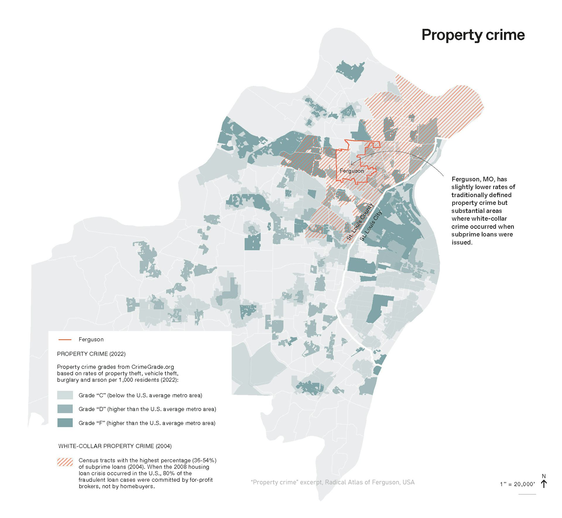
Remapping helps policymakers become more aware of biases within the data they use for mainstream neighborhood assessments and municipal map-making. Maps showing seemingly objective crime data, for example, often reinforce ideas of risk in minority neighborhoods. But when property crime in North St. Louis County, where a majority of Black residents live, is overlaid with the white-collar mortgage fraud crimes of 2008 – a dataset not readily available in typical municipal catalogs – it becomes evident how this area was targeted by subprime mortgage lenders. Broadening how people evaluate data and its sources can shift attention to the underlying forces shaping the statistics.
重新绘制地图有助于政策制定者意识到他们在进行主流社区评估和市政地图绘制时所使用的数据中的偏见。例如,显示看似客观的犯罪数据的地图,往往会强化人们对少数族裔社区风险的观念。但是,当居住着多数黑人居民的北圣路易斯县的财产犯罪数据,与2008年的白领抵押贷款欺诈犯罪数据——这是一个在典型市政目录中不易获得的数据集——叠加时,就显而易见该地区是如何被次级抵押贷款贷款人瞄准的。拓宽人们评估数据及其来源的方式,可以将注意力转移到塑造这些统计数据的潜在力量上。
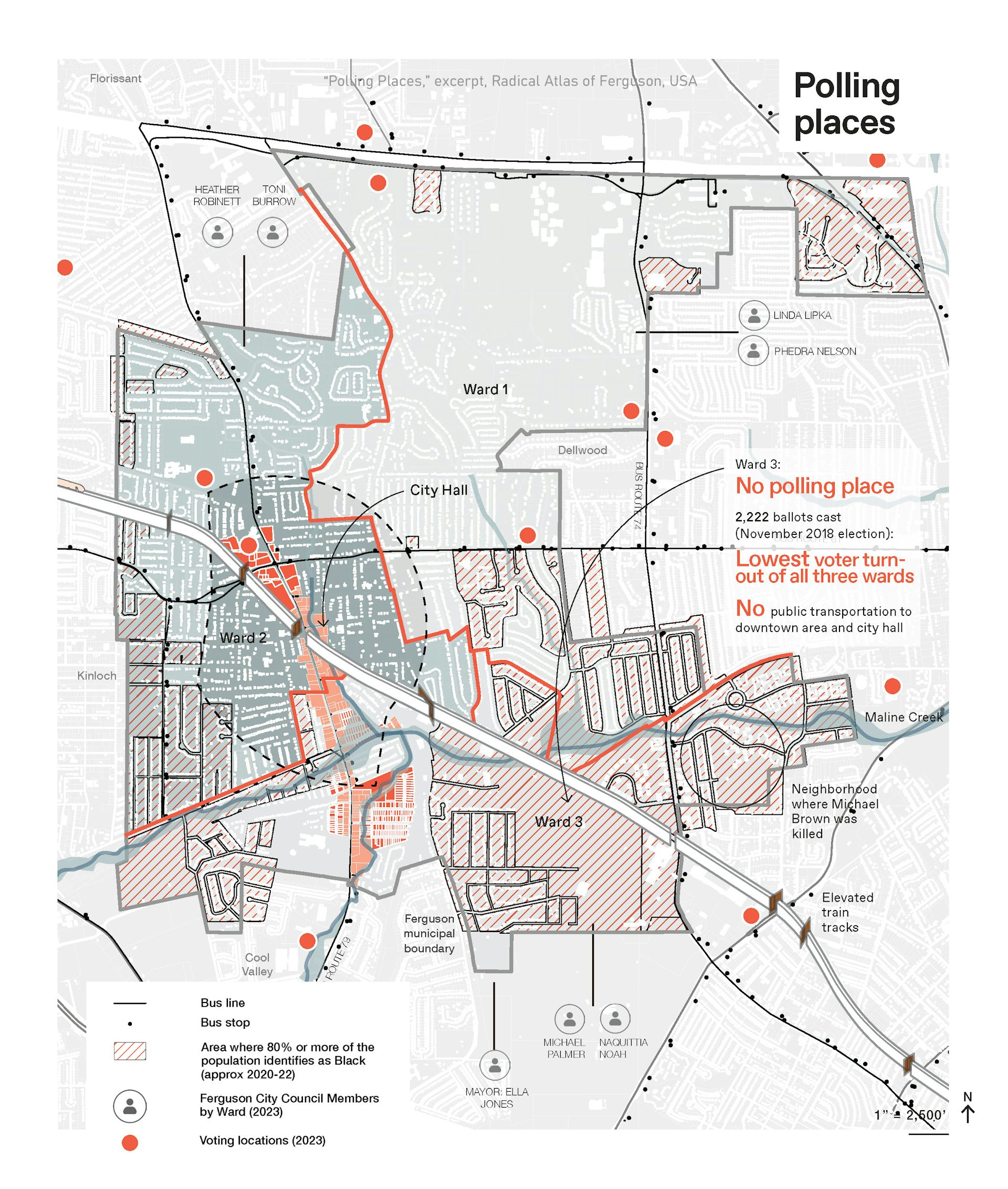
Remapping can also combine layers of seemingly unrelated information to discover new links between spatial details. For example, why is voter turnout so low in the ward where Brown was killed? A map of racial demographics combined with polling locations reveals there is not only no polling place in the majority African American ward, but also physical barriers – including an elevated rail line and stream corridor – that prevent residents from easily accessing City Hall and other polling places.
重绘图还可以结合看似不相关的图层信息,以发现空间细节之间的新联系。例如,为什么在布朗被杀的街区,投票率如此之低?将种族人口统计图与投票点图结合起来显示,该多数非裔美国人街区不仅没有投票点,而且还存在物理障碍——包括高架铁路线和河流廊道——阻碍了居民方便前往市政厅和其他投票点。
Maps for the people
为人民绘制的地图
As those in power continue to politicize maps, the practice of remapping can serve the broader public by making those systems of power more visible to everyone.
随着掌权者持续将地图政治化,重新绘制地图的做法可以通过让所有人都更清楚地看到这些权力系统,从而服务于更广泛的公众。
Counter maps have inspired activists to edit previously omitted information back into mainstream accounts. Mapmaker Andrew Middleton introduced me to one example: a petrofuturist view of the Shell Oil maps. These counter maps show the roads documented in the Shell Oil maps underwater based on projected sea level rise due to climate change – which is caused predominantly by the burning of fossil fuels produced by companies including Shell.
反地图启发了活动家们将先前被忽略的信息重新纳入主流叙事。地图制作者安德鲁·米德尔顿向我介绍了一个例子:从石油未来主义视角审视的壳牌石油地图。这些反地图根据气候变化导致的预计海平面上升,展示了壳牌石油地图上记录的、水下的道路——而气候变化主要由包括壳牌在内的公司燃烧化石燃料所造成。
Maps are scaled geographical projections, ensuring legibility and usefulness. They are understood by people of all ages. They communicate graphically across languages, and they’re portable. When maps and counter maps uncover and layer the otherwise unseen relationships that shape a place, they assert new forms of collective memory, offering more meaningful versions of public authority.
地图是比例尺的地理投影,确保了可读性和实用性。所有年龄段的人都能理解它们。它们能够跨越语言进行图形化交流,而且是便携的。当地图和反地图揭示并叠加了塑造一个地点的、原本不可见的关联时,它们就确立了新的集体记忆形式,提供了更具意义的公共权威版本。
Patty Heyda does not work for, consult, own shares in or receive funding from any company or organization that would benefit from this article, and has disclosed no relevant affiliations beyond their academic appointment.
Patty Heyda 不受任何公司或组织的聘用、咨询、持有股份或获得资金支持,这些公司或组织不会从本文中受益,并且除了其学术任职之外,未披露任何相关隶属关系。
Read more
-

阿耳忒弥斯二号宇航员在再入大气层时将承受3,000°C的高温。一位高超音速专家解释了他们将如何幸存
Artemis II crew will endure 3,000°C on re-entry. A hype…
