محيطات العالم هي الأكثر سخونة المسجلة لشهر يونيو – ومن المتوقع أن تزيد ظاهرة النينو من حدة هذا الاحترار.
The world’s oceans are the hottest on record for June – and El Niño is set to turn up the heat even more
More than 90% of the heat trapped by greenhouses goes into the ocean. But what happens in the oceans doesn’t stay there.
يذهب أكثر من 90% من الحرارة المحتبسة في البيوت الزجاجية إلى المحيط. ولكن ما يحدث في المحيطات لا يبقى محصوراً فيها.
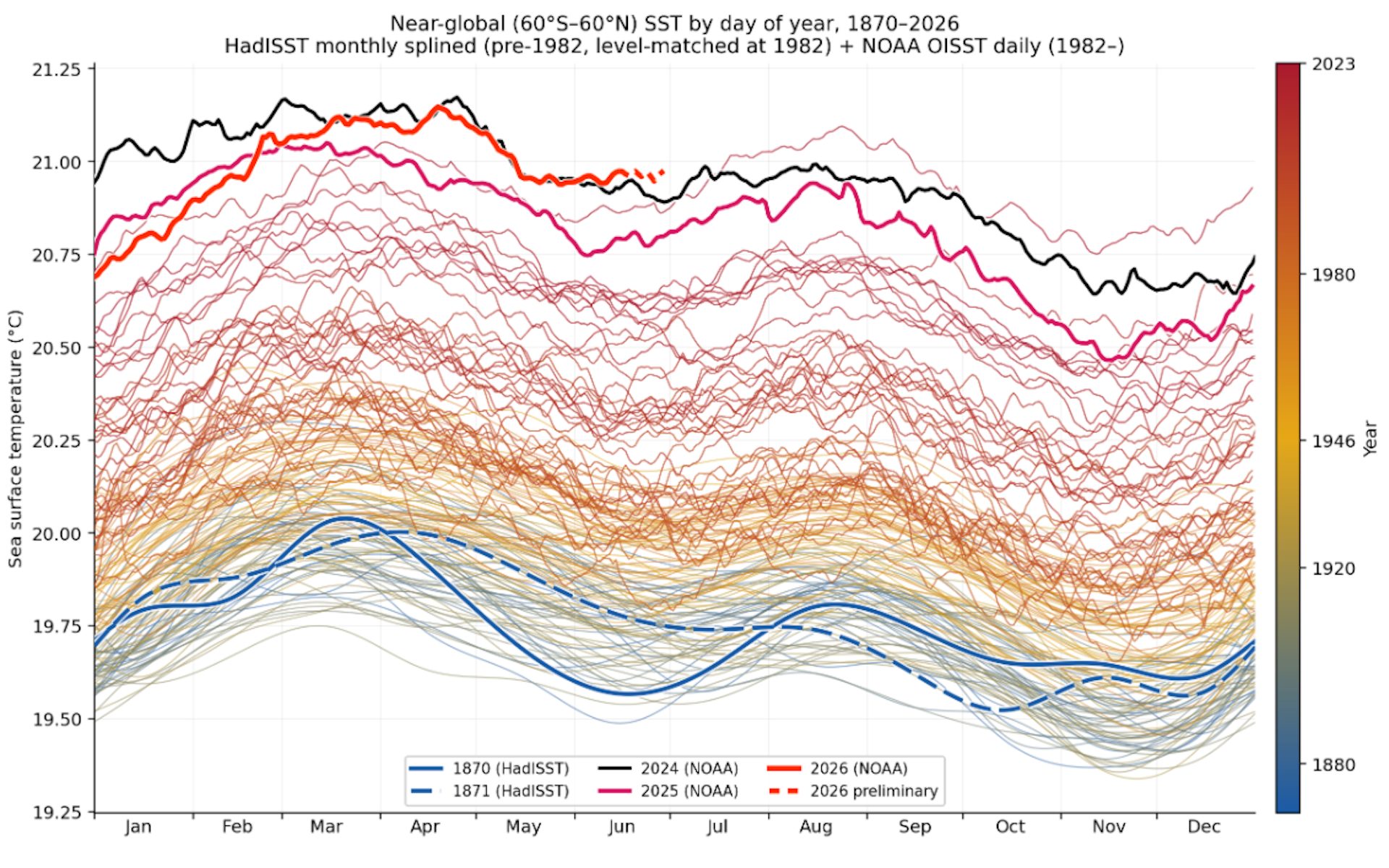
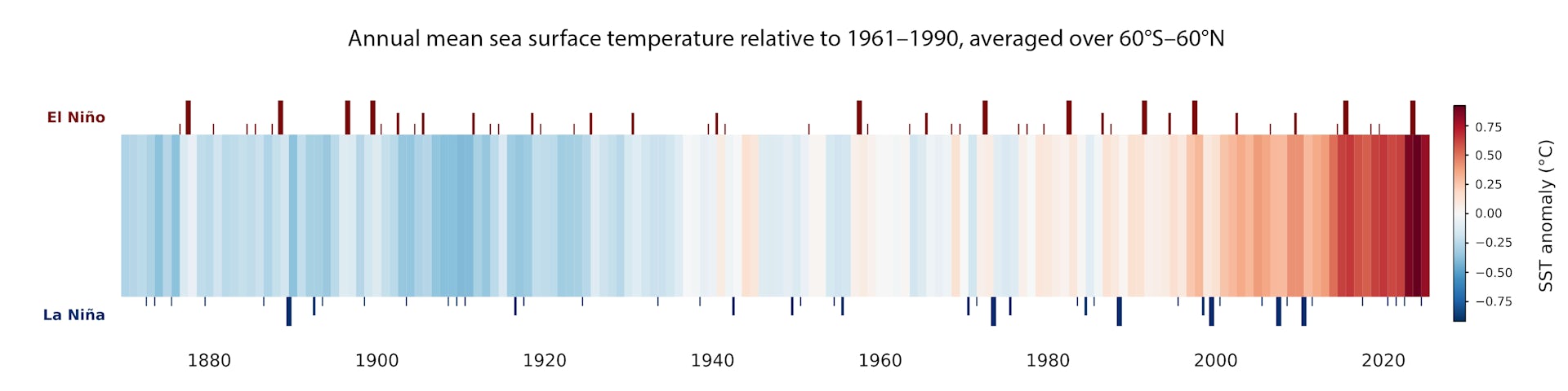
The world’s oceans are the hottest on record for June, pushing past records set during the 2023–24 El Niño years.
المحيطات العالمية هي الأحرارة المسجلة لشهر يونيو، متجاوزة بذلك الأرقام القياسية التي سُجلت خلال سنوات النينو 2023-2024.
Right now, the average sea surface temperature is just under 21°C across the world’s tropical and temperate oceans. Before widespread industrialisation in 1870, the temperature was about 19.6°C.
في الوقت الحالي، يبلغ متوسط درجة حرارة سطح البحر أقل بقليل من 21 درجة مئوية عبر محيطات العالم الاستوائية والمعتدلة. قبل التصنيع الواسع في عام 1870، كانت درجة الحرارة حوالي 19.6 درجة مئوية.
That may not sound like a big difference. But heating the world’s oceans this much requires a truly enormous amount of energy. Of all the extra heat trapped by greenhouse gases from burning coal, gas and oil, more than 90% has gone into the world’s oceans.
قد لا يبدو هذا فرقاً كبيراً. لكن تسخين محيطات العالم بهذا القدر يتطلب كمية هائلة حقاً من الطاقة. ومن إجمالي الحرارة الإضافية المحاصرة بواسطة غازات الدفيئة الناتجة عن حرق الفحم والغاز والنفط، انتقل أكثر من 90% منها إلى محيطات العالم.
As a result, the oceans are getting rapidly warmer. In 2025, the heat added was the equivalent of about 12 Hiroshima-scale nuclear bombs exploding every second of every day.
ونتيجة لذلك، أصبحت المحيطات تزداد دفئاً بسرعة. ففي عام 2025، كان مقدار الحرارة المضافة يعادل حوالي 12 قنبلة نووية بحجم هيروشيما تنفجر كل ثانية من كل يوم.
To find a climate analogue comparable to what’s happening now in the oceans, we would have to go back around 120,000 years to before the last ice age. Back then, slow shifts in Earth’s orbit led it to heat up gradually over thousands of years. Humans have accomplished a similar result in a little over a century.
لإيجاد نظير مناخي قابل للمقارنة بما يحدث الآن في المحيطات، سيتعين علينا العودة إلى ما يقرب من 120,000 سنة قبل آخر عصر جليدي. في ذلك الوقت، أدت التحولات البطيئة في مدار الأرض إلى ارتفاع درجة حرارتها تدريجياً على مدى آلاف السنين. وقد حقق البشر نتيجة مماثلة في فترة تزيد قليلاً عن قرن.
But the heat in the ocean doesn’t just stay there. Hotter oceans fuel stronger cyclones, a more humid atmosphere, more intense rainfall and more heat in air masses over the seas, which can in turn make heatwaves over land more likely and more intense.
لكن الحرارة في المحيط لا تبقى هناك فحسب. فالمحيطات الأكثر دفئاً تغذي الأعاصير الأقوى، والغلاف الجوي الأكثر رطوبة، وهطول الأمطار الأكثر كثافة والمزيد من الحرارة في الكتل الهوائية فوق البحار، مما يمكن أن يجعل موجات الحر على اليابسة أكثر احتمالاً وأكثر شدة بدورها.
The El Niño forming in the tropical Pacific right now is likely to be a big one. As it develops, we can expect to see warmer temperatures and extreme events such as marine heatwaves in the western Indian, tropical Atlantic and eastern Pacific Oceans.
من المرجح أن تكون ظاهرة النينيو التي تتشكل حالياً في المحيط الهادئ الاستوائي كبيرة الحجم. ومع تطورها، يمكننا توقع رؤية درجات حرارة أكثر دفئاً ووقوع أحداث متطرفة مثل موجات الحر البحرية في غرب الهند والمحيط الأطلسي الاستوائي والمحيط الهادئ الشرقي.
Where are the hotspots on land and in the ocean?
أين النقاط الساخنة على اليابسة وفي المحيط؟
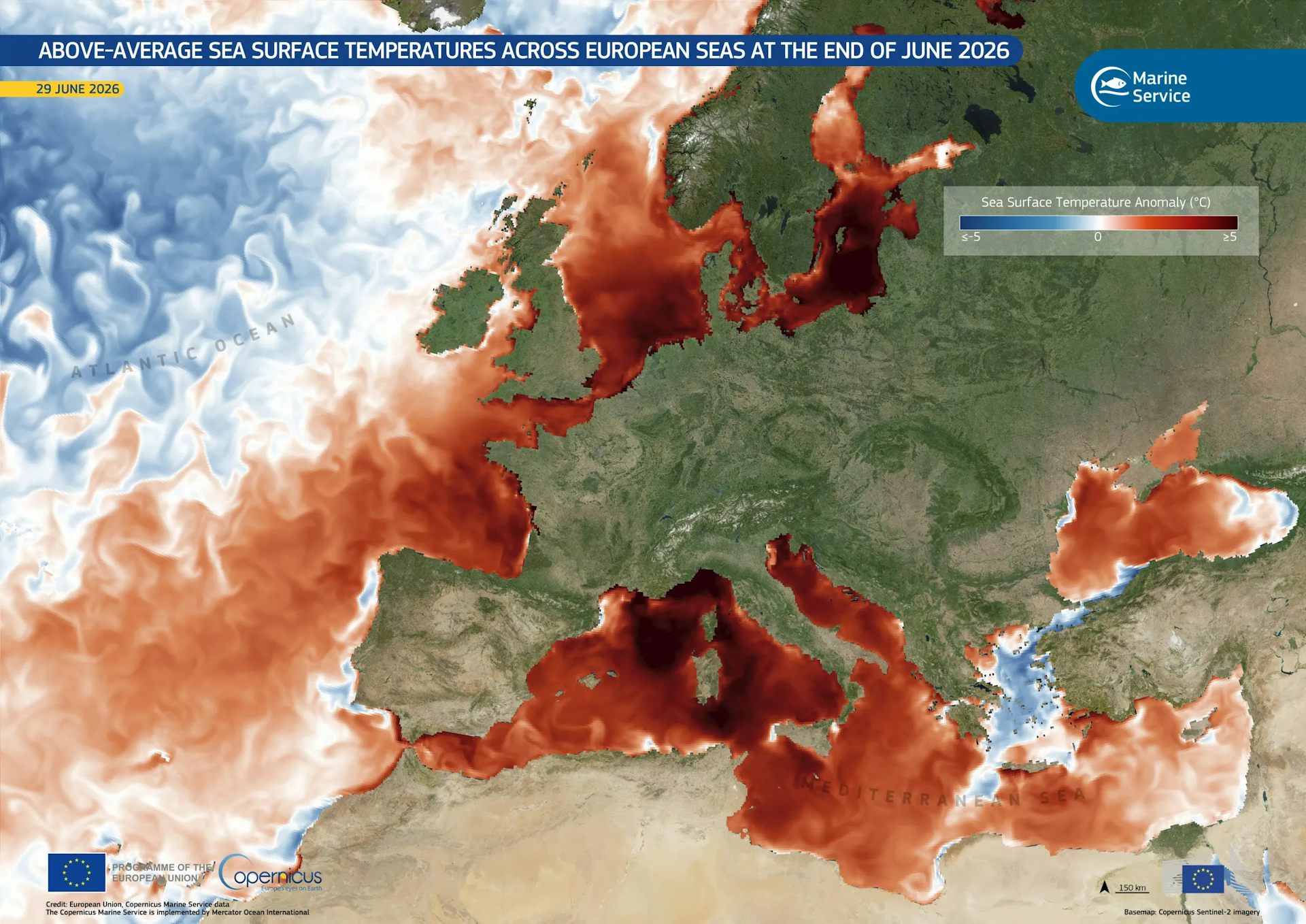
Europe is sweltering through a record-breaking heatwave. The oceans surrounding the region and in enclosed seas are also exceptionally hot.
تتعرض أوروبا لموجة حر قياسية ومحمومة. والمحيطات التي تحيط بالمنطقة وفي البحار المغلقة شديدة الحرارة أيضًا بشكل استثنائي.
Parts of the Mediterranean are up to 6°C hotter than the long-term average.
بعض أجزاء البحر الأبيض المتوسط أعلى بنحو 6 درجات مئوية من متوسط المدى الطويل.
Parts of the North Sea are up to 3°C warmer than average.
أجزاء من بحر الشمال أكثر دفئًا بما يصل إلى 3 درجات مئوية من المعدل الطبيعي.
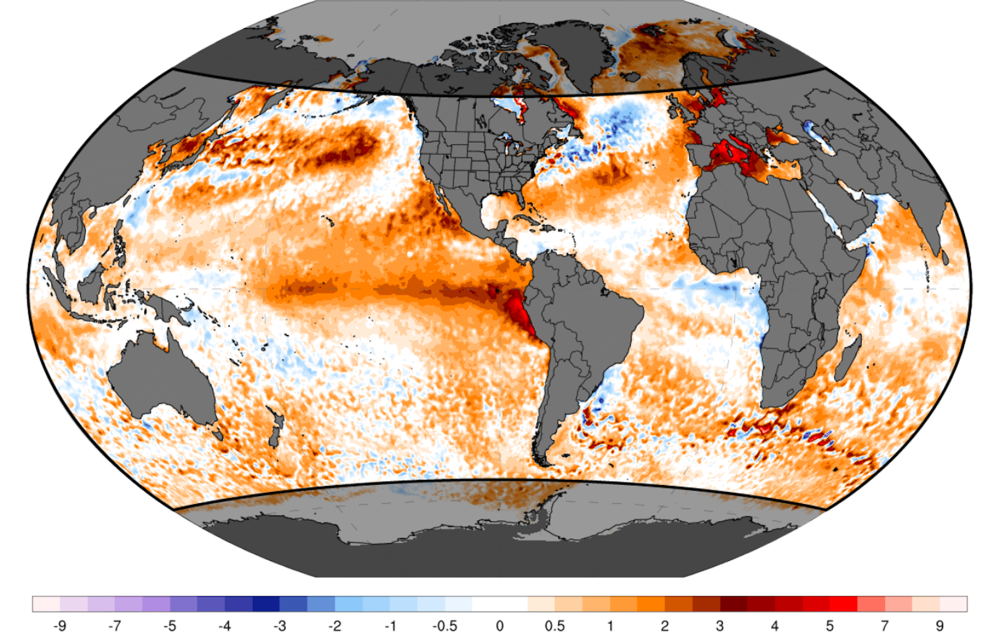
The forming El Niño has led to sea surface temperatures about 1.24°C warmer than average across a large area of the central eastern Pacific.
أدى ظاهرة النينو التي تتشكل إلى ارتفاع درجات حرارة سطح البحر بما يقرب من 1.24 درجة مئوية فوق المعدل الطبيعي عبر مساحة واسعة من المحيط الهادئ الأوسط الشرقي.
There’s much more heat below the surface as well. Subsurface conditions in the eastern Pacific are more than 6°C above average.
هناك المزيد من الحرارة تحت السطح أيضًا. الظروف تحت السطحية في المحيط الهادئ الشرقي أعلى بأكثر من 6 درجات مئوية من المتوسط.
A typical El Niño lasts about a year. The full effect on atmospheric heat becomes clearest towards the end of the cycle. That means while we can expect 2026 to be very hot – perhaps a new record – next year is very likely to be even hotter, as ocean heat is moved back to the surface. We saw this during El Niño events over 2023–24 and 2015–16.
عادة ما تستمر ظاهرة النينو لمدة عام تقريبًا. ويصبح التأثير الكامل على حرارة الغلاف الجوي أوضح مع اقتراب نهاية الدورة. وهذا يعني أنه بينما يمكننا توقع أن يكون عام 2026 حارًا جدًا – وربما يمثل رقمًا قياسيًا جديدًا – فمن المحتمل جدًا أن يكون العام التالي أكثر سخونة، حيث يتم نقل حرارة المحيط إلى السطح. لقد رأينا ذلك خلال أحداث النينو في الفترة ما بين 2023 و 2024 والفترة ما بين 2015 و 2016.
Steady ocean warming coupled with longer-lasting and more intense marine heatwaves pose huge threats to marine ecosystems such as coral reefs, sea grass meadows and coastal reefs. Research on the 2023–24 El Niño and the warm 2024 year showed widespread impacts.
يشكل الاحترار المستمر للمحيطات، مقترنًا بموجات الحر البحرية الأكثر استمرارًا وأشدها كثافة، تهديدات هائلة للنظم البيئية البحرية مثل الشعاب المرجانية ومروج الأعشاب البحرية والشعاب الساحلية. أظهر البحث حول ظاهرة النينو في الفترة 2023-2024 وعام 2024 الدافئ تأثيرات واسعة الانتشار.
From oceans to land
من المحيطات إلى اليابسة
What happens in the oceans doesn’t stay there.
ما يحدث في المحيطات لا يبقى هناك.
In June 2023, a record-breaking marine heatwave broke previous temperature records across the North Atlantic Ocean. Soon afterwards, large areas of Europe were hit by intense heatwaves, while extreme rains triggered deadly floods in Spain and severe bushfires broke out around the Mediterranean.
في يونيو 2023، سجلت موجة حر بحرية قياسية كسرت أرقام درجات الحرارة السابقة عبر شمال الأطلسي. وبعد ذلك بوقت قصير، ضربت مناطق واسعة من أوروبا بموجات حر شديدة، بينما تسببت الأمطار الغزيرة في فيضانات مميتة في إسبانيا واندلعت حرائق غابات شديدة حول البحر الأبيض المتوسط.
Rising ocean temperatures have many consequences.
ارتفاع درجات حرارة المحيط له عواقب عديدة.
A warmer ocean is less able to cool the land over summer. Warmer oceans also lead to more evaporation, boosting humidity and fuelling more intense and more sudden extreme rain and floods. These can have devastating consequences.
المحيط الأكثر دفئًا أقل قدرة على تبريد اليابسة خلال الصيف. كما تؤدي المحيطات الدافئة إلى زيادة التبخر، مما يعزز الرطوبة ويغذي أمطار وفيضانات قصوى أكثر كثافة وأكثر مفاجأة. يمكن أن تكون لهذه العواقب وخيمة.
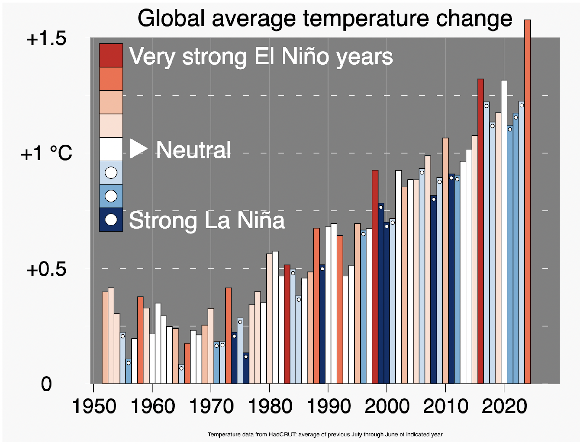
During El Niño events, there’s a clear geographical pattern. The regions we expect to be warmer or cooler during an El Niño roughly reflect where we are more or less likely to get marine heatwaves and more intense tropical cyclones.
خلال أحداث النينو، هناك نمط جغرافي واضح. تعكس المناطق التي نتوقع أن تكون أكثر دفئًا أو برودة خلال فترة النينو تقريبًا المكان الذي من المرجح أن نشهد فيه موجات حر بحرية وأعاصير استوائية أكثر كثافة.
Typical cyclone areas such as the western Indian Ocean could see stronger cyclones dumping heavier rainfall when they hit land. El Niño tends to bring extreme rain and floods to the western South America and dry conditions over parts of Australia and Southeast Asia.
قد تشهد مناطق الأعاصير النموذجية، مثل غرب المحيط الهندي، أعاصير أقوى تطلق أمطاراً غزيرة عند وصولها إلى اليابسة. يميل النينو إلى جلب الأمطار الغزيرة والفيضانات إلى غرب أمريكا الجنوبية وظروف الجفاف في أجزاء من أستراليا وجنوب شرق آسيا.
Can we prepare?
هل يمكننا الاستعداد؟
We are gaining a better understanding of how big climate drivers like El Niño shape weather and how to use ocean data from around the world to develop better seasonal forecasts authorities can use to prepare.
نحن نكتسب فهماً أفضل لكيفية تشكيل المحركات المناخية الكبرى مثل النينو للطقس وكيفية استخدام بيانات المحيطات من جميع أنحاء العالم لتطوير تنبؤات موسمية أفضل تستطيع السلطات استخدامها للاستعداد.
Over the past two years, we have improved our ability to forecast marine heatwaves three to four months ahead in Australia, the United States and other regions. Forecasts give marine authorities a chance to act early by reducing allowable fishery catches and beginning conservation efforts for vulnerable species.
على مدى العامين الماضيين، قمنا بتحسين قدرتنا على التنبؤ بموجات الحرارة البحرية قبل ثلاثة إلى أربعة أشهر في أستراليا والولايات المتحدة ومناطق أخرى. تمنح التوقعات سلطات المحيطات فرصة للعمل مبكراً عن طريق تقليل كميات الصيد المسموح بها وبدء جهود الحفاظ على الأنواع المعرضة للخطر.
This early success in ocean forecasting may be short-lived. The current US administration last year slashed funding for climate data gathering networks and has worked to dismantle the National Center for Atmospheric Research.
قد يكون هذا النجاح المبكر في التنبؤ بالمحيطات قصير الأجل. فقد خفضت الإدارة الأمريكية الحالية العام الماضي التمويل لشبكات جمع بيانات المناخ وعملت على تفكيك المركز الوطني لأبحاث الغلاف الجوي.
This year, the administration announced it would end funding for a key ocean monitoring network before backing down.
في هذا العام، أعلنت الإدارة أنها ستوقف تمويل شبكة رئيسية لمراقبة المحيطات قبل أن تتراجع.
Ongoing collection of ocean data is crucial for ocean and land forecasts. If they are weakened or discontinued, we could face the challenge of dealing with worsening climate impacts blind.
يعد الجمع المستمر لبيانات المحيط أمرًا بالغ الأهمية للتنبؤات المتعلقة بالمحيطات واليابسة. إذا ضعفت أو توقفت، فقد نواجه تحدي التعامل مع تفاقم التأثيرات المناخية بشكل أعمى.
Ending the measuring of climate change won’t stop it happening. The only way to keep climate change from steadily worsening is to reach net zero as soon as humanly possible. Until then, we must use forecasts to prepare for what we can’t avoid.
إن إنهاء قياس تغير المناخ لن يوقف حدوثه. الطريقة الوحيدة لمنع تفاقم تغير المناخ باستمرار هي الوصول إلى صافي انبعاثات صفري في أقرب وقت ممكن على المستوى البشري. حتى ذلك الحين، يجب علينا استخدام التوقعات للاستعداد لما لا يمكننا تجنبه.
Matthew England receives funding from the Australian Research Council.
يتلقى ماثيو إنجلاند تمويلاً من المجلس الأسترالي للبحوث.
Alex Sen Gupta receives funding from the Australian Research Council.
يتلقى أليكس سين غوبتا تمويلاً من المجلس الأسترالي للبحوث.
Alistair Hobday does not work for, consult, own shares in or receive funding from any company or organisation that would benefit from this article, and has disclosed no relevant affiliations beyond their academic appointment.
أليستير هوبدي لا يعمل لدى، أو يشارك في استشارات، أو يمتلك أسهمًا في، أو يتلقى تمويلًا من أي شركة أو منظمة يمكن أن تستفيد من هذه المقالة، ولم يفصح عن أي انتماءات ذات صلة تتجاوز تعيينه الأكاديمي.
Read more
-
أبولونيا: قصة مملكة أفريقية قاومت تجارة الرقيق الأطلسية
Appolonia: the story of an African kingdom that resisted the Atlantic slave trade
-

إدارة ترامب تدّعي “انتصاراً” على إيران – إليكم تقرير الأداء
Trump administration claiming a ‘win’ against Iran – here’s a report card