
地震可能对建立在盆地的遥远城市造成破坏——现在我们了解了原因
Earthquakes can be destructive for distant cities built…
Flat basins are favoured places to build cities. But seismic waves can get trapped in these basins, putting cities at risk from distant earthquakes.
平坦的盆地一直是建设城市的理想场所。但地震波可能会在这些盆地内滞留,从而使城市面临来自远处地震的风险。
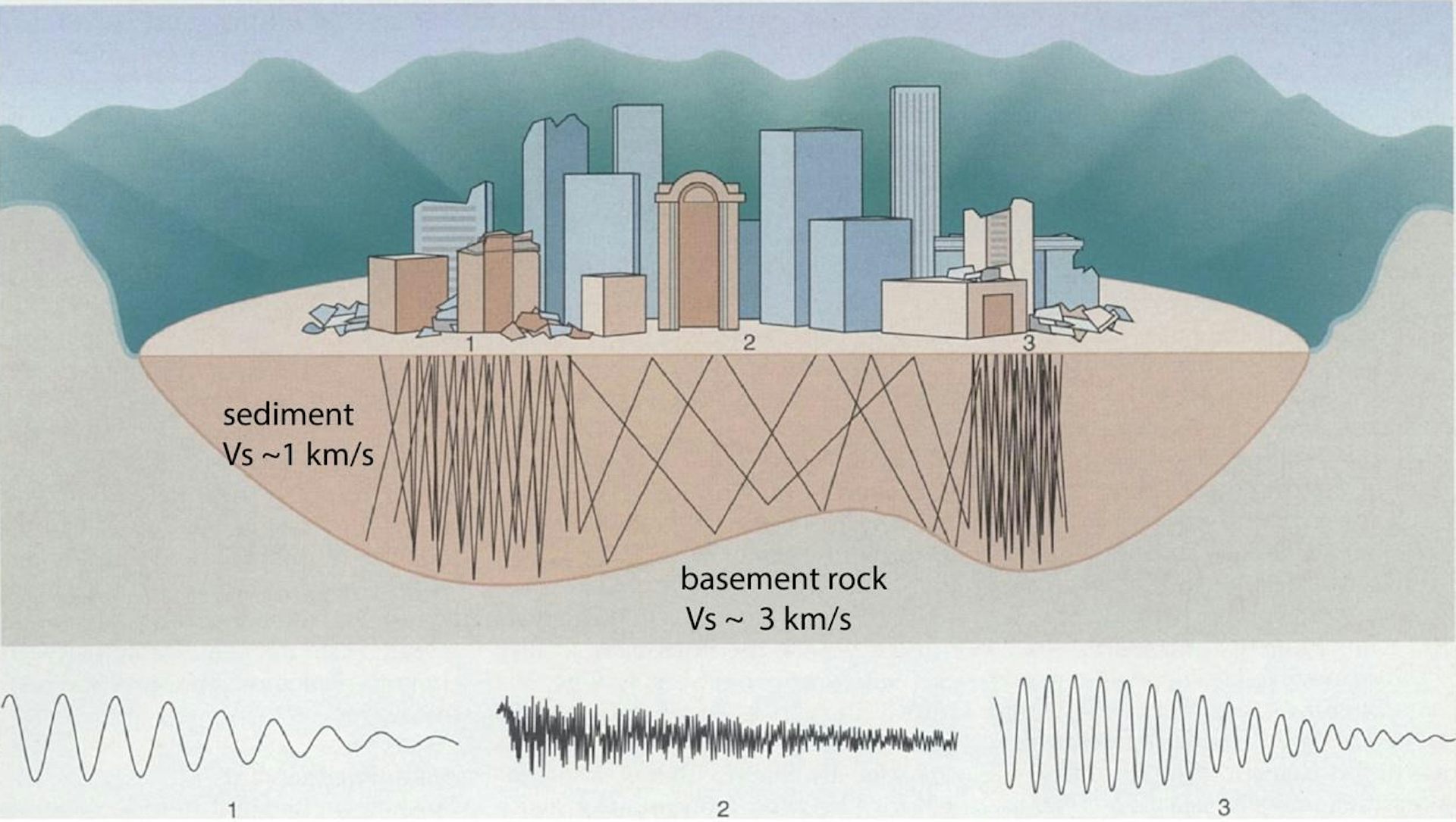
Sedimentary basins – depressions in Earth’s crust caused by tectonic activity – tend to be flat and are favoured places to build cities. But during earthquakes, they can become natural resonance chambers.
沉积盆地——由构造活动引起的地球地壳凹陷处——通常是平坦的,是建设城市的理想地点。但在地震期间,它们可能会成为天然的共振腔。
Just like sound waves echoing around an empty hall, this means seismic waves can get trapped in these basins and bounce from side to side to create “seismic echoes”.
就像声波在空旷的大厅中回荡一样,这意味着地震波可以在这些盆地中被困住,从一侧反弹到另一侧,从而产生“地震回音”。
Depending on the shape and depth of the basin, these echoes can become amplified and be highly destructive.
根据盆地的形状和深度,这些回音可能会被放大,变得具有高度破坏性。
New Zealand’s capital city Wellington is built on a sedimentary basin and is an example of this phenomenon.
新西兰的首都惠灵顿建在一个沉积盆地上,是这种现象的一个例子。
In the 2016 magnitude 7.8 Kaikōura earthquake, Wellington’s central business district experienced shaking that exceeded design predictions. Even though the quake was located 80 kilometres from the city, it caused severe damage to infrastructure, with many multi-storey buildings damaged or destroyed.
在2016年里氏7.8级凯科乌拉地震中,惠灵顿市中心经历了超出设计预测的摇晃。尽管这次地震位于城市80公里处,但它仍对基础设施造成了严重破坏,许多多层建筑受损或被摧毁。
Archival records also show that during the 1942 magnitude 7.3 Wairarapa quake, which was located about 80 kilometres north of Wellington, some 10,000 chimneys were destroyed in the city.
档案记录还显示,在1942年里氏7.3级怀拉拉帕地震中,该地震位于惠灵顿以北约80公里处,城市内有大约1万个烟囱被摧毁。
Our new research provides an updated model for the central Wellington basin.
我们的新研究为惠灵顿中心盆地提供了一个更新的模型。
We found it is almost twice as deep (about 500 metres) than previously thought and that its shape is significantly different from the previous model. These differences go some way toward explaining why the shaking was stronger than expected.
我们发现它比以前认为的更深(约500米),并且其形状与之前的模型显著不同。这些差异在一定程度上解释了为什么摇晃比预期更强。
The deadliest example from history
历史上最致命的例子
Historically, the most devastating example of seismic echoes, or trapped waves, was the 1985 Mexico City earthquake, which killed 8,000 people and destroyed high-rise buildings.
从历史上看,最破坏性的地震回波或“陷阱波”的例子是1985年的墨西哥城大地震,这场地震造成了8000人死亡并摧毁了高层建筑。
The quake’s epicentre was 350 kilometres west of the city, but when waves of moderate amplitude arrived in the city, they became trapped in the low-wave-speed sediments of the basin on which it is built and became amplified.
地震的震中位于城市以西350公里处,但当振幅适中的波到达城市时,它们被困在城市所建盆地低速沉积物中并被放大。
As the waves bounced from side to side, they created a standing wave, similar to water waves in a bath.
当波在两侧反弹时,它们形成了一种驻波,类似于浴缸中的水波。
As a result, the city experienced specific narrow zones of extreme destruction, underscoring the risk from even very distant earthquakes for cities built on sedimentary basins.
因此,该城市经历了特定狭窄区域的极端破坏,突显了建立在沉积盆地上的城市即使面临非常遥远的地震也存在风险。
Seismic echo chambers
地震回声室
Seismic waves become trapped and amplified for two main reasons.
地震波会因为两个主要原因而被困并放大。
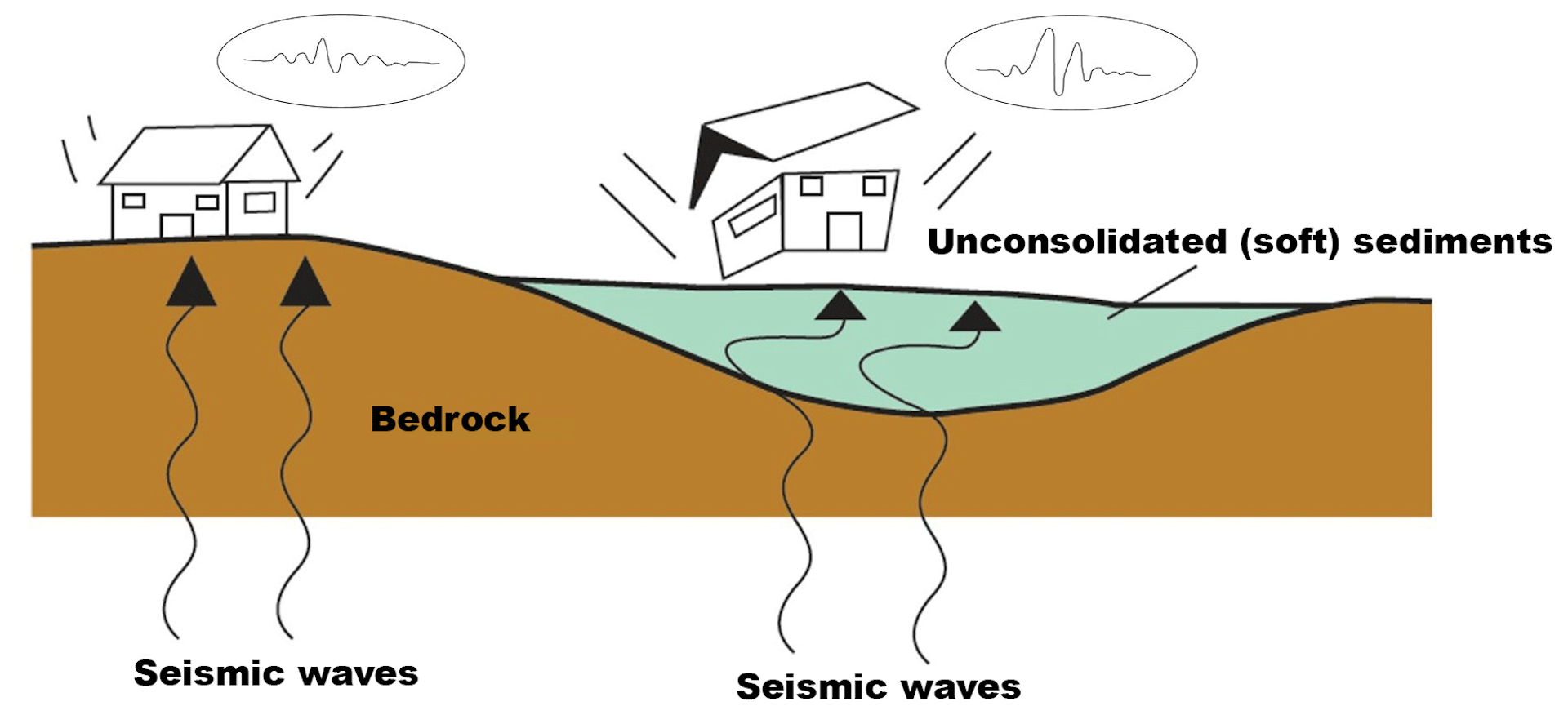
First, as the waves move from a fast wave-speed medium (solid basement rocks) to the low wave-speed of sedimentary rocks, the amplitude of the waves will increase to compensate for the drop in wave speed.
首先,当波从快速传播介质(坚硬的基底岩石)移动到沉积岩的低速介质时,为了补偿波速下降,波的振幅会增加。
This is similar to a tsunami wave that travels across the deep ocean with a small amplitude but high speed, and then, as it comes closer to shore in shallow water, slows down but dramatically increases in amplitude.
这类似于海啸波:它在深海中以小振幅但高速传播,然后,当它靠近浅滩时,速度减慢,但振幅却急剧增大。
This interchange between wave amplitude and speed is to do with the energy of the waves, which must remain constant.
波振幅和波速之间的这种相互作用与波的能量有关,而能量必须保持恒定。
The second reason for the amplification of seismic waves in a basin is resonance – when the wavelengths of the incoming seismic waves are similar to either the vertical and horizontal dimensions of the basin.
在盆地内,地震波放大的第二个原因是共振——即入射地震波的波长与盆地的垂直和水平尺寸相似时发生。
If the basin has steep sides, an edge effect is also generated where strong amplification can occur close to the edge of the basin due to a buildup of different wave types.
如果盆地具有陡峭的侧壁,还会产生一种边缘效应,由于不同类型的波堆积作用,可能在靠近盆地边缘的地方发生强烈的放大。
Perhaps the most surprising of our findings is the shape of the basin under Wellington. Its effective western edge is not the Wellington Fault, as previously assumed.
我们发现中最令人惊讶的是惠灵顿下方盆地的形状。其有效的西部边缘并非如先前假设的惠灵顿断层。
Instead, the edge cuts across the basin at a high angle to the Wellington fault and follows the line of two previously identified, low-activity faults – the Terrace and Lambton faults.
相反,该边缘以高角度切穿了盆地,并沿着两条先前已识别的低活动性断层——特拉塞断层和兰姆顿断层的走向延伸。
These differences between the new and old basin models have significant impacts on the predicted shaking Wellington might expect. In particular, there will be an effect linked to the newly described edge, and the predicted amplification will be higher for a deeper basin.
新旧盆地模型之间的这些差异对惠灵顿可能预期的震动具有重大影响。特别是,与新描述的边缘相关的效应存在,并且预测的放大作用在更深的盆地中会更高。
We used a 3D model of the basin in a computer simulation for the shaking at frequencies of 0.7 Hertz (the dominant shaking frequency recorded during past quakes) . We found that the amplifications of horizontal ground motion could be 2.5-3 times the background level adjacent to the western edge of the basin.
我们使用了一个三维模型在计算机模拟中研究了该盆地的振动情况,频率为0.7赫兹(这是过去地震记录的主要振动频率)。我们发现,盆地西部边缘附近的水平地面运动放大倍数可能是背景水平的2.5至3倍。
When we compared this predicted pattern of amplified shaking to where the actual damaged buildings were located during the Kaikōura earthquake, we observed some correlation with the western edge of the basin.
当我们把这种预测的放大震动模式与开科拉地震期间实际受损建筑的位置进行比较时,我们在盆地的西部边缘观察到了一些相关性。
However, we need to be cautious when making this comparison as this pattern could be linked to other factors, such as the distribution of reclaimed land and clustering of inadequately designed buildings.
然而,在进行这种比较时我们需要谨慎,因为这种模式可能与其他因素有关,例如人工填海分布和设计不当建筑群的聚集。
Our study nevertheless highlights two key points.
尽管如此,我们的研究强调了两个关键点。
First, simple geophysical methods can now be used in urban areas to map out the depth and shape of basins that cities are built on. From these models, we can then generate computer simulations to predict the location of amplified shaking.
首先,现在可以在城市地区使用简单的地球物理方法来绘制出城市所建盆地的深度和形状。利用这些模型,我们可以生成计算机模拟来预测放大震动的位置。
This will lead to more granular zoning for what parts of cities may be more vulnerable.
这将有助于对哪些城市部分可能更脆弱进行更精细的划分。
The second key point is higher awareness of the risk to cities built on sedimentary basins from not only local, but also distant earthquakes.
第二个关键点是提高了人们对建立在沉积盆地上的城市面临风险的认识,这种风险不仅来自局部地震,也来自远距离地震。
Timothy Stern has received funding from the NZ Earthquake Commission (EQC) for the initial gravity survey; QuakeCore for some of the seismic work; and from an internal Victoria University grant for student stipend support.
Timothy Stern 获得了新西兰地震委员会(EQC)关于初始重力勘探的资金;获得 QuakeCore 关于部分地震工作的资助;并获得了维多利亚大学内部拨款支持学生津贴。

