
يمكن أن تكون الزلازل مدمرة للمدن البعيدة المبنية فوق الأحواض – والآن نعرف السبب
Earthquakes can be destructive for distant cities built on top of basins – now we know why
Flat basins are favoured places to build cities. But seismic waves can get trapped in these basins, putting cities at risk from distant earthquakes.
تُعد الأحواض المسطحة أماكن مفضلة لبناء المدن. لكن الموجات الزلزالية يمكن أن تنحصر في هذه الأحواض، مما يعرّض المدن للخطر من الزلازل البعيدة.
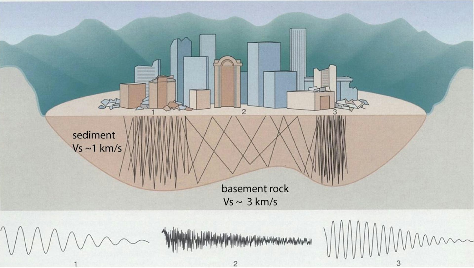
Sedimentary basins – depressions in Earth’s crust caused by tectonic activity – tend to be flat and are favoured places to build cities. But during earthquakes, they can become natural resonance chambers.
الأحواض الرسوبية – وهي منخفضات في قشرة الأرض تسببها الأنشطة التكتونية – تميل إلى أن تكون مسطحة وتُعد أماكن مفضلة لبناء المدن. ولكن أثناء الزلازل، يمكن أن تتحول هذه الأحواض إلى حجرات رنين طبيعية.
Just like sound waves echoing around an empty hall, this means seismic waves can get trapped in these basins and bounce from side to side to create “seismic echoes”.
تماماً مثل أصداء الموجات الصوتية في قاعة فارغة، يعني هذا أن الموجات الزلزالية يمكن أن تُحاصر في هذه الأحواض وتتردد من جانب لآخر لتُنشئ “أصداء زلزالية.”
Depending on the shape and depth of the basin, these echoes can become amplified and be highly destructive.
اعتماداً على شكل وعمق الحوض، يمكن أن تتضخم هذه الأصداء وتكون مدمرة للغاية.
New Zealand’s capital city Wellington is built on a sedimentary basin and is an example of this phenomenon.
تُبنى العاصمة نيوزيلندا، ويلينغتون، على حوض رسوبي وهي مثال على هذه الظاهرة.
In the 2016 magnitude 7.8 Kaikōura earthquake, Wellington’s central business district experienced shaking that exceeded design predictions. Even though the quake was located 80 kilometres from the city, it caused severe damage to infrastructure, with many multi-storey buildings damaged or destroyed.
في زلزال كايكوورا الذي بلغت قوته 7.8 درجة عام 2016، شهد وسط مدينة ويلينغتون اهتزازات تجاوزت التوقعات التصميمية. وعلى الرغم من أن الزلزال كان يقع على بعد 80 كيلومتراً من المدينة، إلا أنه تسبب في أضرار بالغة للبنية التحتية، حيث تعرض العديد من المباني متعددة الطوابق للتلف أو الدمار.
Archival records also show that during the 1942 magnitude 7.3 Wairarapa quake, which was located about 80 kilometres north of Wellington, some 10,000 chimneys were destroyed in the city.
كما تُظهر السجلات الأرشيفية أنه خلال زلزال وايرارابا الذي بلغت قوته 7.3 درجة عام 1942، والذي كان يقع على بعد حوالي 80 كيلومتراً شمال ويلينغتون، دُمر ما يقرب من 10,000 مدخنة في المدينة.
Our new research provides an updated model for the central Wellington basin.
يقدم بحثنا الجديد نموذجاً مُحدّثاً لحوض ويلينغتون المركزي.
We found it is almost twice as deep (about 500 metres) than previously thought and that its shape is significantly different from the previous model. These differences go some way toward explaining why the shaking was stronger than expected.
وجدنا أنه أعمق بمرتين تقريباً (حوالي 500 متر) مما كان يُعتقد سابقاً، وأن شكله مختلف بشكل كبير عن النموذج السابق. تساهم هذه الاختلافات في تفسير سبب كون الاهتزاز أقوى من المتوقع إلى حد ما.
The deadliest example from history
أخطر مثال في التاريخ
Historically, the most devastating example of seismic echoes, or trapped waves, was the 1985 Mexico City earthquake, which killed 8,000 people and destroyed high-rise buildings.
تاريخياً، كان المثال الأكثر تدميراً للصدى الزلزالي، أو الموجات المحاصرة، هو زلزال مدينة مكسيكو عام 1985، الذي أودى بحياة 8000 شخص ودمر المباني الشاهقة.
The quake’s epicentre was 350 kilometres west of the city, but when waves of moderate amplitude arrived in the city, they became trapped in the low-wave-speed sediments of the basin on which it is built and became amplified.
كان مركز الزلزال على بعد 350 كيلومتراً غرب المدينة، ولكن عندما وصلت موجات ذات سعة معتدلة إلى المدينة، علقت في الرواسب منخفضة سرعة الموجة في الحوض الذي بنيت عليه وتضخمت.
As the waves bounced from side to side, they created a standing wave, similar to water waves in a bath.
مع ارتداد الموجات من جانب إلى آخر، أوجدت موجة واقفة، شبيهة بموجات الماء في حوض الاستحمام.
As a result, the city experienced specific narrow zones of extreme destruction, underscoring the risk from even very distant earthquakes for cities built on sedimentary basins.
ونتيجة لذلك، شهدت المدينة مناطق ضيقة ومحددة من الدمار الشديد، مما يؤكد الخطر الناجم حتى عن الزلازل البعيدة جداً للمدن المبنية على الأحواض الرسوبية.
Seismic echo chambers
غرف الصدى الزلزالية
Seismic waves become trapped and amplified for two main reasons.
تُحاصر الموجات الزلزالية وتتضخم لسببين رئيسيين.
First, as the waves move from a fast wave-speed medium (solid basement rocks) to the low wave-speed of sedimentary rocks, the amplitude of the waves will increase to compensate for the drop in wave speed.
أولاً، عندما تنتقل الموجات من وسط ذي سرعة موجية عالية (صخور الأساس الصلبة) إلى صخور رسوبية ذات سرعة موجية منخفضة، سيزداد سعة الموجات للتعويض عن انخفاض سرعة الموجة.
This is similar to a tsunami wave that travels across the deep ocean with a small amplitude but high speed, and then, as it comes closer to shore in shallow water, slows down but dramatically increases in amplitude.
يشبه هذا موجة تسونامي التي تسافر عبر المحيط العميق بسعة صغيرة ولكن بسرعة عالية، ثم عندما تقترب من الشاطئ في المياه الضحلة، تتباطأ ولكنها تزداد بشكل كبير في السعة.
This interchange between wave amplitude and speed is to do with the energy of the waves, which must remain constant.
يرجع هذا التبادل بين سعة الموجة وسرعتها إلى طاقة الموجات، التي يجب أن تبقى ثابتة.
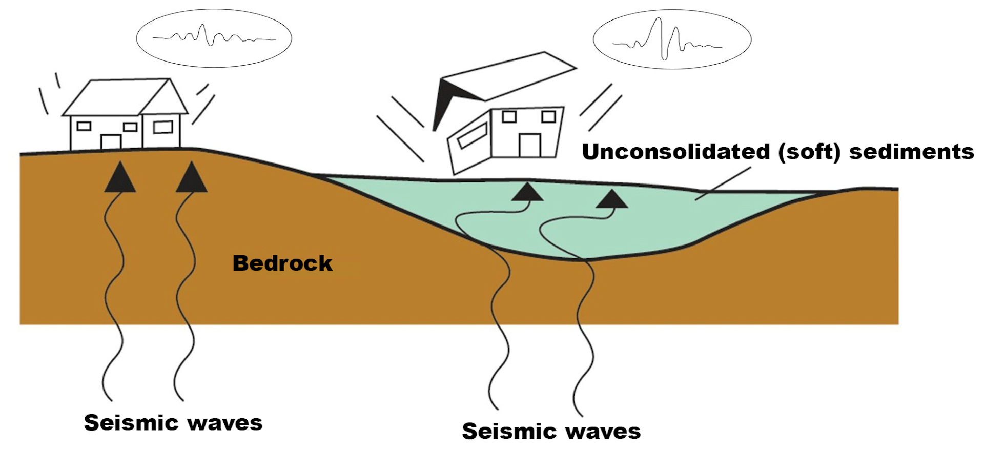
The second reason for the amplification of seismic waves in a basin is resonance – when the wavelengths of the incoming seismic waves are similar to either the vertical and horizontal dimensions of the basin.
السبب الثاني لتضخيم الموجات الزلزالية في حوض هو الرنين – عندما تكون أطوال موجات الموجات الزلزالية الواردة مماثلة إما للأبعاد العمودية والأفقية للحوض.
If the basin has steep sides, an edge effect is also generated where strong amplification can occur close to the edge of the basin due to a buildup of different wave types.
إذا كان الحوض ذو جوانب شديدة الانحدار، فسيتم أيضاً توليد تأثير حافّة حيث يمكن أن يحدث تضخيم قوي بالقرب من حافة الحوض بسبب تراكم أنواع مختلفة من الموجات.
Perhaps the most surprising of our findings is the shape of the basin under Wellington. Its effective western edge is not the Wellington Fault, as previously assumed.
ربما يكون أكثر ما أثار دهشتنا في نتائجنا هو شكل الحوض تحت مدينة ويلينغتون. إن حافته الغربية الفعلية ليست صدع ويلينغتون، كما كان مفترضاً سابقاً.
Instead, the edge cuts across the basin at a high angle to the Wellington fault and follows the line of two previously identified, low-activity faults – the Terrace and Lambton faults.
بدلاً من ذلك، يقطع الحافة الحوض بزاوية عالية بالنسبة لصدع ويلينغتون ويتبع خط اثنين من الصدوع ذات النشاط المنخفض التي تم تحديدها مسبقاً – وهما صدع تيراس وصدع لامبتون.
These differences between the new and old basin models have significant impacts on the predicted shaking Wellington might expect. In particular, there will be an effect linked to the newly described edge, and the predicted amplification will be higher for a deeper basin.
للتفاوتات بين نماذج الحوض الجديدة والقديمة تأثيرات كبيرة على الاهتزاز المتوقع الذي قد تتوقعه ويلينغتون. وعلى وجه الخصوص، سيكون هناك تأثير مرتبط بالحافة الموصوفة حديثًا، وسيكون التضخيم المتوقع أعلى بالنسبة لحوض أعمق.
We used a 3D model of the basin in a computer simulation for the shaking at frequencies of 0.7 Hertz (the dominant shaking frequency recorded during past quakes) . We found that the amplifications of horizontal ground motion could be 2.5-3 times the background level adjacent to the western edge of the basin.
استخدمنا نموذجاً ثلاثي الأبعاد للحوض في محاكاة حاسوبية للاهتزاز عند ترددات 0.7 هرتز (التردد المهيمن للرجفة المسجلة أثناء الزلازل الماضية) . ووجدنا أن تضخم الحركة الأرضية الأفقية يمكن أن يكون 2.5 إلى 3 أضعاف المستوى الأساسي المجاور للحافة الغربية للحوض.
When we compared this predicted pattern of amplified shaking to where the actual damaged buildings were located during the Kaikōura earthquake, we observed some correlation with the western edge of the basin.
عندما قارنا هذا النمط المتوقع للاهتزاز المضخم بمكان وجود المباني التالفة الفعلية أثناء زلزال كايكوأورا، لاحظنا بعض الارتباط بالحافة الغربية للحوض.
However, we need to be cautious when making this comparison as this pattern could be linked to other factors, such as the distribution of reclaimed land and clustering of inadequately designed buildings.
ومع ذلك، نحتاج إلى توخي الحذر عند إجراء هذه المقارنة لأن هذا النمط قد يرتبط بعوامل أخرى، مثل توزيع الأراضي المستصلحة وتكتل المباني المصممة بشكل غير كافٍ.
Our study nevertheless highlights two key points.
ومع ذلك، تسلط دراستنا الضوء على نقطتين رئيسيتين.
First, simple geophysical methods can now be used in urban areas to map out the depth and shape of basins that cities are built on. From these models, we can then generate computer simulations to predict the location of amplified shaking.
أولاً، يمكن الآن استخدام طرق جيوفيزيائية بسيطة في المناطق الحضرية لرسم خرائط لعمق وشكل الأحواض التي تُبنى عليها المدن. ومن هذه النماذج، يمكننا بعد ذلك إنشاء محاكاة حاسوبية للتنبؤ بموقع الاهتزاز المضخم.
This will lead to more granular zoning for what parts of cities may be more vulnerable.
سيؤدي هذا إلى تقسيم أكثر دقة لما قد تكون أجزاء من المدن عرضة للخطر.
The second key point is higher awareness of the risk to cities built on sedimentary basins from not only local, but also distant earthquakes.
النقطة الرئيسية الثانية هي زيادة الوعي بالمخاطر التي تواجه المدن المبنية على الأحواض الرسوبية ليس فقط من الزلازل المحلية، ولكن أيضاً من الزلازل البعيدة.
Timothy Stern has received funding from the NZ Earthquake Commission (EQC) for the initial gravity survey; QuakeCore for some of the seismic work; and from an internal Victoria University grant for student stipend support.
تلقى تيموثي ستيرن تمويلاً من لجنة نيوزيلندا للزلازل (EQC) للمسح الجاذبي الأولي؛ وشركة كويك كور (QuakeCore) لبعض الأعمال الزلزالية؛ ومن منحة داخلية من جامعة فيكتوريا لدعم مكافأة الطلاب.
Read more
-

أفضل ستة تكييفات لشكسبير ليست باللغة الإنجليزية
The six best Shakespeare adaptations that aren’t in English
